The term "overrunning" appears in various sorts of weather discussions on a regular basis, and it is guaranteed to create a reaction on my part if I hear the word. I have two main problems with the word: 1) at times it is not obvious that everyone agrees on what it means, and 2) even if one assumes what I believe to be the commonly-accepted meaning of the term, it fails to convey anything meaningful about the meteorology.
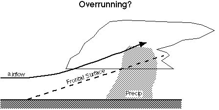
Exactly what do we mean by overrunning? Well, it might mean that air aloft is overrunning air at lower levels. If this is one's interpretation of the term, it makes no sense. Air at upper levels overruns air at lower levels nearly all the time, whenever there is vertical shear. No, that can't be the interpretation of the term. Perhaps it means the classic "snow plow" effect of flow over a front, as suggested by Fig. 1
Figure 1. Schematic showing one interpretation of the term "overrunning" that presumably "explains" precipitation on the cold side of a frontal boundary.
This picture conveys the impression that the flow is roughly perpendicular to the boundary. Many times, however, the flow becomes nearly parallel to the boundary above the surface, say at 850 or 700 mb (oh, all right, hPa if you "SI units" nit-pickers prefer!!). This doesn't seem to match the picture implied in Fig. 1 does it? Of course, strictly speaking, one must consider the airflow relative to the moving boundary ... but this can be difficult to pin down. I think the "snowplow" image is not necessarily the right one for interpretation of the term, either.
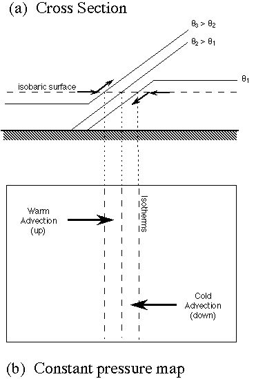
Sometimes, of course, the flow does retain a significant component normal to the boundary with height. That seems to suggest that sometimes, the word might be acceptable, right? Well, I want to point out that when the flow retains a component normal to the boundary, this can be described another way: thermal advection. Let's take a look at what thermal advection means on a constant pressure surface. Consider Fig. 2a, showing a cross section through a front and Fig. 2b, an isobaric map of the same front. If we assume that the flow is adiabatic, can the parcels in the zone of thermal advection stay on the same pressure surface? No, not if the flow is adiabatic; they have to stay on the isentrope where they start. Hence, regions of warm advection imply upward motion, and regions of cold advection imply downward motion. Thus, rather than the "snowplow" effect, this can fruitfully be viewed as vertical motion associated with thermal advection, or isentropic up/down-gliding.
Figure 2. Schematic showing how thermal advection on an isobaric surface is equivalent to isentropic up/down-glide. Note that on a p-surface, an isentrope is equivalent to an isotherm.
It seems to me that the idea that what users of "overrunning" are trying to convey in most cases is precipitation on the cold side of a thermal boundary. For some reason, the occurrence of such precipitation seems to necessitate another, special term. Let me grant for the moment that we might wish to have such a special term, and that "overrunning" is a candidate for such a term. Let me ignore for the moment that we have no such special term for precipitation occurring on the warm side of a thermal boundary. Presumably, precipitation along a thermal boundary could be called frontal precipitation. Consider now what this special term offers to us.
Cases of precipitation on the cold side of thermal boundaries arise mostly in one of two situations (sometimes both at once):
a. Thermal Advection
As noted above, there are occasions wherein the physical picture of the situation reveals that the upward motion is associated with warm thermal advection. Sharp readers might observe that warm thermal advection is one of the contributing terms in the quasigeostrophic "omega" equation. A physical explanation for this has already been given here and elsewhere, and presumes some reasonable adherence to the adiabatic flow approximation.
b. Differential Vorticity Advection
In most of the situations that do not fit the thermal advection interpretation, it is found that the precipitation is in a region wherein cyclonic vorticity advection increases with height. Again, a sharp reader will observe that this is the second major contributor (out of two!) to the QG omega equation. A physical explanation for how differential vorticity advection is associated with vertical motion is found elsewhere. Nevertheless, this interpretation of "precipitation on the cold side of a thermal boundary" ("overrunning") ought to be a favorite with many forecasters who like to "explain" nearly everything with the "poor man's omega equation": positive vorticity advection ("PVA") = upward motion. [I've dealt with this excessive oversimplification elsewhere, and am only taking a brief portion of this narrative to assert its bankruptcy in meteorological applications.] Nevertheless, it seems that the PVA-lovers often lose their infatuation with PVA as a universal explanation in favor of "overrunning"!
At this point, if "overrunning" is assumed to be synonymous with "precipitation on the cold side of a thermal boundary" then the uselessness of such a term in science-based weather forecasting ought to be obvious! There are at least two quite distinct physical processes (there may well be others!), both of which are capable of producing precipitation on the cold side of a thermal boundary, so when you use "overrunning" to "explain" what is happening, have you really explained the process physically? Hardly!! All you have done is give a specific precipitation event a name, but you have failed to distinguish which of (at least) two physical processes is producing the event. If you then have to go on and describe which type of overrunning you are referring to, then it seems to me that identifying "overrunning" as a special term has been entirely without value.
In summary, then, I propose that meteorologists abandon this term as one without an agreed-upon meaning, and with no value in a science-based interpretation of precipitation events.