and
Czech Hydrometeorological Institute, Prague, Czech Republic
This essay has not been, nor is it likely to be, submitted anywhere for publication. Rather, it's been put out to elicit reactions to this admittedly nit-picky point. Comments sent via Internet e-mail to me at: cdoswell # earthlink.net (use the email hyperlink or cut and paste the address, replacing ' # ' with '@') will be welcomed, even if they're critical. I've included updates based on some recent feedback, for your interest and enjoyment.
It's been common terminology to refer to the precipitation within a mesoscale convective system (MCS) as comprising "convective" and "stratiform" components. The use of this terminology is quite widespread (see e.g., Loehrer and Johnson 1995; Rutledge et al. 1988; Smull and Houze 1985; and many others), with a schematic echo structure illustrating these two precipitation components shown in Fig. 1 of Loehrer and Johnson (1995). Although it is apparent that the mechanisms producing the radar echoes in these two areas within an MCS are almost certainly not the same, it is not obvious that the term "stratiform" is appropriately descriptive. The Glossary of Meteorology (Huschke 1959, p.545) describes "stratiform" as pertaining to clouds of extensive horizontal development, in contradistinction to "cumuliform." Insofar as this refers to clouds, one certainly could argue that the precipitation falling from the trailing anvil of an MCS is of extensive horizontal development. When discussing stratus clouds, the Glossary (op. cit., p. 547) notes that stratus clouds generally produce little or no precipitation and what little might fall consists of minute particles (e.g., drizzle).
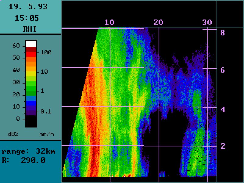
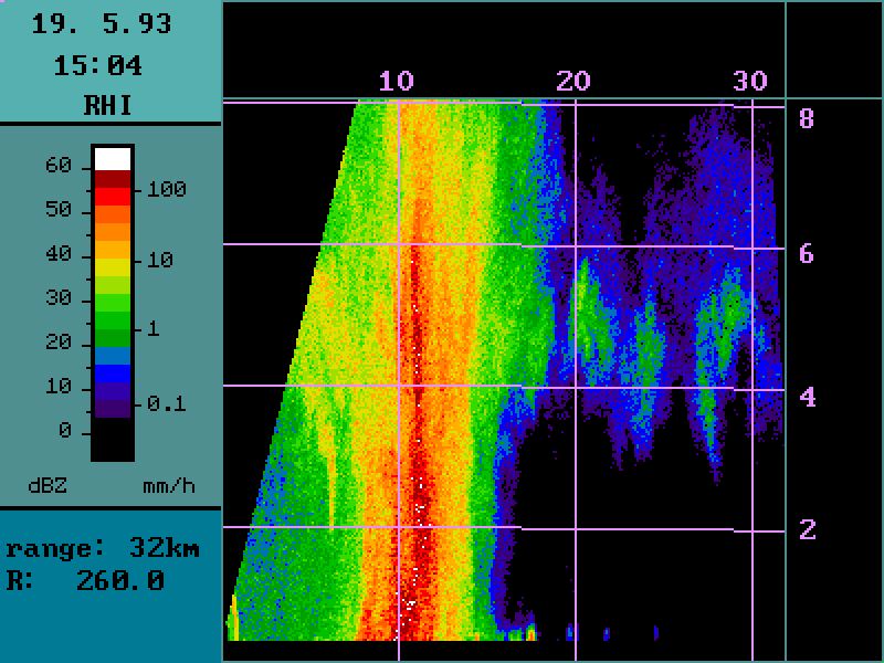
The extensive area of precipitation produced from an MCS' trailing anvil does not typically fall as drizzle. Rather, the rainfall can assume a moderate intensity (~10 mm hr-1) with the intensity flucutating markedly, giving it a showery character. Further, there are measurements of the vertical motion within MCS anvils (Smull and Houze 1987) indicating vertical motions within the anvil of several meters per second. These characteristics are not very compatible with what one calls to mind when thinking of "stratiform" precipitation. To emphasize this point, consider Figs. 1 and 2. These images from the 3 cm radar at Prague in the Czech Republic reveal quite clearly the difference between the so-called "stratiform" precipitation region of a small MCS and truly stratiform precipitation.
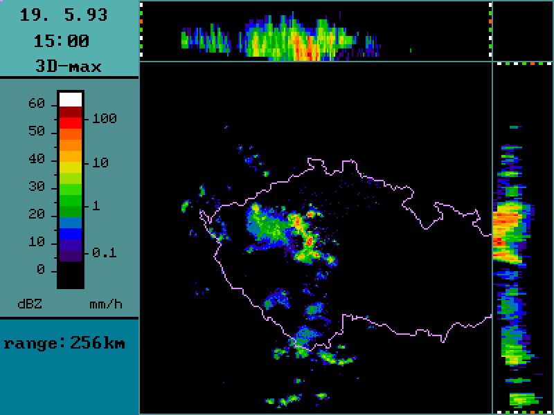
The MCS on 19 May 1993 is shown at about 1500 UTC to the west-northwest of the radar. The RHIs shown in Fig. 1a and Fig. 1b reveal a distinctly cellular character to the anvil, in spite of the fairly uniform field of maximum reflectivity at low levels beneath the trailing anvil (Fig. 1c). This view of the anvil certainly suggests a nonhomogeneous anvil.
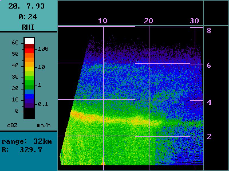
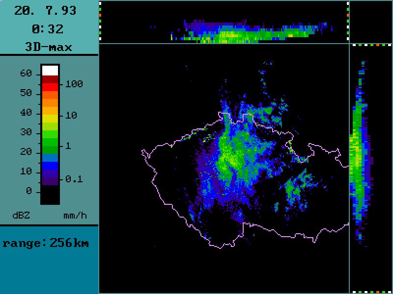
On the other hand, the truly stratiform activity on 20 July 1993 reveals a dramatically different nature on radar. The cross section (Fig. 2a) reveals mainly the bright band with relatively little horizontal variation in intensity, while the plan view shows some slight fluctuations with mainly very weak reflectivity (generally < 40 dBz, indicative of small precipitation particles). In fact, the plan view of the truly stratiform precipitation in Fig. 2b seems to show as much or even more horizontal variation than the so-called "stratiform" region of the MCS; the real difference in the character is shown most dramatically in the cross sections.
It appears to us that the term "stratiform" is misapplied in this context. Although this might be considered to be a minor semantics point, nevertheless terminology can convey implications that are not intended. To view the area of precipitation associated with the anvil as "stratiform" might lead one to believe that the horizontal variations within the anvil are of little or no importance, whereas it appears that substantial structure exists in the anvil. We believe the "stratiform precipitation" nomenclature ought to be changed to something more descriptive; perhaps to something like "trailing anvil precipitation."
Acknowledgments. The lead author's trip to Prague where these radar images were first seen was supported by the Joint Czechoslovak-United States Science and Technology Program, Project No. 94067.
Huschke, R.E., 1959: Glossary of Meteorology. Amer. Meteor. Soc., 638 pp.
Loehrer, S.M., and R.H. Johnson, 1995: Surface pressure and precipitation life cycle characteristics of PRE-STORM mesoscale convective systems. Mon. Wea. Rev., 123, 600-621.
Rutledge, S.A., R.A. Houze, Jr., M.I. Biggerstaff, and T. Matejka, 1988: The Oklahoma-Kansas mesoscale convective system of 10-11 June 1985: Precipitation structure and single-Doppler radar analysis. Mon. Wea. Rev., 116, 1409-1430.
Smull, B.F., and R.A. Houze, Jr., 1985: A midlatitude squall line with a trailing region of stratiform rain: Radar and satellite observations. Mon. Wea. Rev., 113, 117-133.
______, and ______, 1987: Dual-Doppler radar analysis of a midlatitude squall line with a trailing region of stratiform rain. J. Atmos. Sci., 44, 2128-2148.
Update: 27 October 2008
*The standard disclaimer applies here. That is, my responses to these comments are purely my own opinions and do not necessarily reflect those of the National Severe Storms Laboratory, or CIMMS. If I've inadvertently left out anyone in the chain of command, they're not claiming any responsibility for this, either!
The following comments have been offered by Brad Smull, at my request, as representing an alternative viewpoint in the question of "stratiform" terminology. They have been edited only trivially.
Although I believe the available refereed literature on this subject essentially speaks for itself, as a friend and colleague with some experience in the area I am compelled to respond to your note criticizing the use of the terminology "stratiform precipitation" in Smull and Houze (1985, Mon. Wea. Rev., 113, 117-133) and elsewhere.
First, I would like to offer some background (abridged though it is). The interested reader is referred to Houze (1993, Cloud Dynamics, Academic Press, 570 pp, esp. his Chapter 6) for a more complete discussion. The original application of the adjective 'stratiform' to precipitation is generally attributed to Houghton (1950, J. Meteor., 7, 363-369; also 1968, J. Appl. Meteor., 7, 851-859). In applying this term, Houghton's emphasis was on the distinguishing microphysics of the precipitation process, which are closely tied to the character and magnitude of in-cloud vertical motions. As such, the salient property defining stratiform precipitation (following Houze 1993) is that the vertical air velocity w satisfies the condition |w| < Vice, where Vice is the terminal fall velocity of ice crystals and snow (~1-3 m/s). Under these conditions, stratiform precipitation particles are perpetually falling as they grow (initially via vapor deposition, but ultimately through aggregation and light riming as they near the melting level). This is in marked contrast to the convective precipitation mechanism, in which upward vertical air motions exceed the terminal fall speed of growing particles, thus lofting them so that rapid growth may occur via accretion of liquid water. It follows that another distinction between these two contrasting modes is that the time scale for convective precipitation (generally < 1 h) is considerably shorter than that for stratiform rain (~1-3 h). More recently, quantitative radar reflectivity data showing cellular vs. highly stratified echo structure embodying a crisply defined "bright band" near the melting level have been identified as signatures of these two modes. As such, the active microphysics and associated radar-derived 4-D structure are much more important than precipitation intensity per se. In spite of your repeated citations, I take the fact that the AMS Glossary (Huschke 1959) is currently undergoing revision as evidence that it is outdated or otherwise lacking in many regards.
As detailed by Houze (1993), this distinction is indeed complicated by the frequent coexistence of these two contrasting modes, most notably within mesoscale convective systems. The stratiform "anvil" cloud and associated region of stratiform precipitation that develops adjacent to (most often trailing) mature deep convection within MCSs owes its very existence to the upward transport of water vapor originating in the boundary layer to heights at/above the prevailing midlevel stratiform cloudbase. This water vapor, along with cloud ice and small snow particles detrained from convective updrafts, are critical inputs to the dynamically active stratiform region. In the common circumstance of organized multicellular convection, in which individual convective cells preferentially form/dissipate on the leading/trailing borders of the convective region, entire column-like regions associated with dissipating convection are effectively transferred from the convective to stratiform region, with the elapsed time required for this transfer allowing for a transition from one dominant mode of growth to the other. In his study of tropical MCSs, Brown (1979, J. Atmos. Sci., 36, 313-338) applied the classic Latin genre to coin the term "nimbostratus cumulonimbogenitus" which, albeit lengthy, may ultimately be a more complete (and thus accurate) descriptor of stratiform cloud features in MCS settings.
My principal quarrel with your informal essay is that the radar data examples shown in your Figs. 1a-b do not reflect the mature-to-decaying phase of MCS development in which the terminology "stratiform" has been applied by either me or my many colleagues working in this area. As shown by Leary and Houze (1979, J. Atmos. Sci., 36, 437-457, esp. their Fig. 1) and others, there is obviously an evolutionary process inherent in the observed transition from convective --> stratiform structure. The aforementioned examples are restricted to narrow (i.e. young) convective band. It would be interesting to see how this structure evolved over the subsequent hour or so, or alternatively RHIs extending to more distant ranges toward the northwest of the radar site (cf. Fig. 1c) where the PPI display and derived cross-sectional projections show more horizontally homogeneous, widespread echo suggestive this later stage of development seen over Severocesky in the far northwest Czech Republic ... for those without an updated atlas, refer to here. I believe you would be hard-pressed to find an analyst--either human or as expressed via a rule set/algorithm--that would classify any part of your Figs. 1a-b as "stratiform."
I risk stating the obvious by saying that virtually any classification scheme proposing dichotomous atmospheric structures must be viewed as representing two extremes in a veritable continuum. For example, Leary and Rappaport (1987, Mon. Wea. Rev., 115, 1503-1527) present evidence of weak yet organized banded precipitation structures (likely associated with mid-to-upper level convection) accompanying a mesovortex within the otherwise "stratiform" trailing region of a west- Texas squall line/MCC. A more widely recognized example of this phenomenon within cool-season baroclinic cyclones is the presence of "generating cells" within the upper reaches of nimbostratus and the associated "seeder-feeder" mechanism (cf. Chapter 6.2 of Houze 1993). As a veteran of many hours of P-3 research flights within stratiform precipitation regions of MCSs over Oklahoma and elsewhere, I can say anecdotally that observations of heavily rimed graupel-type particles and convective-type vertical motions (apart from mechanically generated turbulence within strongly-sheared layers and near evaporating edges of stratiform regions) are extremely rare even in the face of significant electrification and reflectivities locally exceeding 40 dBZ within the bright band. Houze (1993) allows that the degree to which the criteria |w| < Vice is everywhere locally satisfied across stratiform regions (as opposed to in terms of their areally-averaged vertical mass flux and mean mesoscale updraft strength) is in need of testing via additional observations. It is my hope that the advent of instrumented jet aircraft in our research fleet will ultimately allow collection of more hard data of the in situ microphysical variety to address these important questions.
--
Bradley Smull
NOAA/NSSL Research Meteorologist*
and Research Associate Professor
*Brad is no longer affiliated with NSSL.
I have just browsed through your web page's "Stratiform precip note", and you mentioned that "Comments sent via Internet e-mail will be welcome, even if they are simply flames". I couldn't resist the offer ;-) though I'll try to be a bit more constructive.
Disclaimer: My experience is "Montreal-centric" so that may affect my views somewhat.
I have looked at the data in your Fig 1 and 2 and have several comments about them. The first are about the MCS. I may be wrong, but when I think MCS I think about the classical Pre-STORM case that has been studied and modelled so often (sorry, I don't know the date) with a nice line of convection followed by a large band of "stratiform" precipitation. Your storm with 10-20 km of precipitation behind the convective cell is fairly different. Based on your image and my fair experience with the interpretation of cross-sections of radar data, your "stratiform" precipitation has the appearance of graupels melting; graupels are not the kind of beasts you find in stratiform rain because their formation requires significant vertical velocities so in that sense it is not really stratiform precipitation.
But that is precisely my point. In my experience with MCSs, the cases with nice gentle vertical motions over broad areas are outnumbered by cases more closely resembling the example in our note. At the risk of starting a whole new issue, it seems to me that the so-called stratiform (or trailing) precip fills a spectrum, perhaps with extremes being relatively rare. I do not think it appropriate to derive a term based on the extrema at the margins of a spectrum.
If you take the central-US kind of MCS (see also TOGA-COARE data in Atlas et al., 27th radar conf. p. 20), the area of precipitation behind the storm has a radar characteristic much closer to that of stratiform precipitation. Modelling studies suggest that that "stratiform" precipitation may be considerably "seeded" by frozen hydrometeors ejected by the main updraft, giving some credence to your approach. However, in its growth (some of the resulting snowflakes are huge, dentritic structures that have low density) and its melting in a narrow region, it has a lot of the characteristics of stratiform precipitation.
On your stratiform cases: I have about 800 hours of vertical profiles of reflectivity in stratiform in my possession and I can tell you that the really stratiform structures like the one in your Fig. 2 are the exception rather than the rule. Considerable structure can be observed in the form of precipitation trails and small scale fluctuations in and around the melting layer.
But the same argument can be made (I just did) for the "stratiform" region of trailing precip. I have seen a lot of analyses that involve small embedded regions of vertical velocities exceeding one meter per second, which I would assert (I did!) is not very consistent with most notions of "stratiform" precip, even if truly "stratiform" precip contains structure. Having looked out of a lot of airplane windows when passing over stratocumulus decks, I have no problem believing in your observed structure ... are you really wanting to imply homogeneity when your own data suggest that embedded structure is the rule, not the exception?
In general, when I saw events that combined "stratiform" and "convective" precipitation (as determined from radar cross-sections alone), whether they were from MCS or not, the profiles generally were like this: A narrow (though sometimes not that narrow) zone of intense reflectivity that extends much higher than the melting level; A transition zone where weak reflectivities were present, and where there was a hint that melting of fast moving frozen hydrometeors (hence no bright band) were melting in a fairly narrow region (sometimes significant w was observed by profiler ~ 2+ m/s, most often not); A region that looks like stratiform rain, with obviously snow above the 0C level and rain below, with a very narrow melting region that is well defined by its radar signature --> negligible vertical velocities.
In conclusion, while I agree that on some occasions precipitation just behind a convective cell is "perturbed" and may owe its origin to the convective cell, the large bands of precipitation behind MCS will fit most definitions of "stratiform rain".
I think we can agree to disagree here. My reading of "stratiform" has too many implications of horizontal homogeneity. If your observations suggest otherwise, that does not change the connotations many folks accept without question. If stratiform precip is not horizontally homogeneous most of the time, then perhaps it's time for a (I hate to say it!) paradigm change? At least we need to think carefully about what we want "stratiform" to mean!
Given the turbulent nature of the atmosphere, IMHO, it is unrealistic to limit the definition of "stratiform" precipitation to a field that has only 1-D characteristics. That may sound like an oxymoron to you.
Well, it might well be unrealistic, but that is the implication of the definition I quoted out of the Glossary.
My definition of stratiform is probably based more on microphysics than on dynamics. It includes events where the updrafts are smaller than a critical threshold beyond which considerable amount of liquid water are brought up. As long as the amount of water brought up is limited, the microphysics of all "stratiform" events are indistinguishible: if precipitation starts in the frozen form, you will have ice crystals at first, snow after (sometimes partly rimed), and then it melts in a narrow region to rain. Considerable 3-D structure may be observed, but the microphysics is basically the same. When the updrafts are important, considerable amount of water is brought up and changes the nature of hydrometeors. Above the 0C level, you will observe supercooled raindrops, graupels, and maybe even hail, as opposed to 100% snow for the "stratiform" cases.
If one follow this definition, then indeed your event does not contain "stratiform" precipitation because the frozen hydrometeors appear to be mostly graupel. However, in other MCSs, you do have mostly if not 100% snow above the 0C level, so it is "stratiform".
Well, I cannot speak authoritatively about the character of the precipitation above the 0C level in MCSs, but I do know that within the "stratiform" part of most of the MCSs I've experienced, the rain has a showery character with rainfall rates that often would qualify as moderate. This does not seem consistent with an input above 0C of nothing but snow. Perhaps your experiences are different from mine ... you DID say your experience is mostly "Montreal-centric" and mine is mostly "US Great Plains-centric."
This "microphysics" definition is harder to extend to "all water" events (from drizzle to warm rain showers) but the same threshold to vertical velocity could be applied.
My definition of stratiform stems from my radar data analysis. It is likely that when people talk of stratiform rain, they may have something very 1-D in mind.
That is precisely my point! If most people have some erroneous notions in mind when we use a particular term, then we either need to change the definition or use a different term.
I think that a definition of stratiform vs convective vs something else should be based on physical processes rather than on pure "1-D structure vs 2-D or 3-D structure". Because almost everything has 3-D structure. After all, even stratiform rain has boundaries.... ;-)
I have seen in Montral very stratiform rain (at least using my definition, with very nice and well defined bright bands) with reflectivities in excess of 40 dBZ in rain, and even exceeding 45 dBZ on occasions.
In those situations, is the observed rainfall rate very steady or is it showery, with lots of temporal variation in rate? My experience is that the low-level radar structural is more uniform than that aloft and that even though the low-level echoes look pretty uniform, the actual rainfall is more showery than steady. Given the variations in vertical velocity observed in "stratiform" regions, with changes of several m per sec over distances of a few km (including sign changes!), my view of the trailing precip region is that is has a substantial convective component, even though it is nowhere near as intense and variable as it is in the "convective" region of the MCS.
On the definition of stratiform: Changing it, OK. To what?
It is not so easy to change it as you seem to suggest. You and I could very well come to some sort of agreement about how to change it, but we have to convince a substantial portion of the community. As for how I would like to change it ... I'd have to think about that, but whatever I conclude, I agree with you that it should be reality/physics-based, and not carry any residual assumptions that do not match what we know about reality/physics. It we can change the definition of the term to match what we see going on in the trailing precip regions of MCSs, then I might withdraw my concerns. Of course, this also means (implicitly) that we need to define "convective" as well. I am happy to take these sorts of things on, but I don't believe for a nanosecond that changing attitudes about these terms is going to be a matter of publishing a paper.
We have an unresolved point (maybe) here: I include a lot in my stratiform definition (yes indeed, I have one too!) but not what you show behind these MCS. Do you?
In one sense (i.e., that of a person calling all trailing precip "stratiform"), I guess I am. On the other hand, I obviously don't like the term "stratiform" used in the context of describing all trailing precipitation ... I used this case precisely to exemplify that point! Note that I have already pointed out (in our exchange) the existence of a spectrum of trailing precip structures, perhaps including extreme cases that might well fit the term "stratiform" in the sense of horizontal homogeneity.
Another thought to add: On the misconceptions of people about what I call stratiform rain. Flow-wise and microphysics-wise, stratiform rain is fairly 1-D. However, when it comes to precipitation patterns which are extremely sensitive to minute changes in the flow (e.g. convergence areas), things may be different. I mean by that that the field of precipitation intensity will be much more structured than most other fields (temperature, moisture, winds, etc).
Here comes the hard-to-swallow piece: hence a lot of the parameters in the atmosphere will be "stratiform"; precipitation is the one that will be the less so. It is just infortunate that our view is radar - and hence precipitation - centric.
Concerning your additional thought: I clearly support the idea that higher-order variations (i.e., convergence and/or vertical motion) exist (and are physically relevant) in most trailing "stratiform" precip regions. The quasi-homogeneity of some of the base observations is irrelevant in this dynamical context. If we call something "stratiform" this seems to suggest that we understand the processes producing the precipitation and so need look no further. I am troubled by the structure that I (and you) see in these regions. You choose to not be bothered by the term because your definition of "stratiform" encompasses such variations ... the one that I quoted (and which is commonly accepted, I think) relegates the dynamics of "stratiform" precip to the pile of solved problems. Since my leanings are more dynamical than microphysical, I think I can see at least some of the source for our different views of the issue.
I believe that a lot of the exchange between Frederic and me is relevant to Brad's "quarrel" with my essay. It's clear to me that the primary distinction being drawn by my "detractors" (Please ... no negatives are being implied! I'm pleased that someone has taken the time to respond to my original challenge, and I'm grateful to them, not unhappy!) is based on a microphysical view of the processes, whereas I believe that my concern in the whole argument is tied to their implications of horizontal homogeneity and simple dynamical processes (akin to the development of unambiguously stratiform precipitation in cases of large-scale weak ascent). I continue to believe that by using the term "stratiform" we are sweeping a lot of horizontal inhomogeneity under the rug, perhaps unintentionally, and with it tends to go any dynamics that may be operating to produce those inhomogeneities.
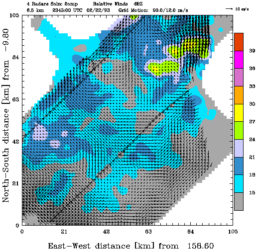
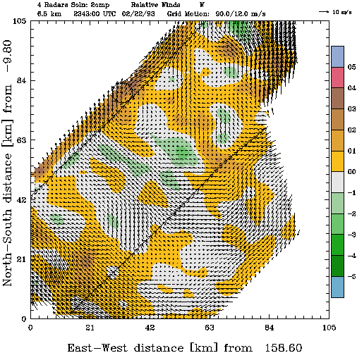
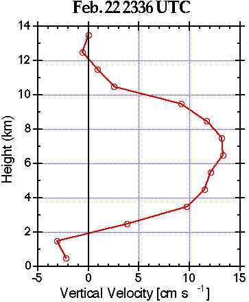
With the help of my colleague, Dr. David Jorgensen of NSSL/Boulder, Co, I've included some figures that illustrate the reasons for the stance I've adopted. These are data taken from the NOAA P-3 aircraft, using the tail Doppler radar to create synthetic dual-Doppler wind fields. The data are from the TOAGA-CORE experiment and I suggest you contact Dave for the details; Fig. 1 shows the Doppler data analysis grid and the aircraft flight tracks superimposed on the reflectivity field from the fuselage (non-Doppler) radar. Figure 2 shows the Doppler-derived wind field within the analysis grid and the 6.5 km reflectivity field. Figure 3 shows the line-relative winds (the movement of the convective line has been subtracted and the kinematically-derived vertical motions at 6.5 km. Figure 4 shows the profile of vertical motions, derived by averaging the vertical velocities at each level over the analysis domain. I wish to point out that although the domain averaged vertical motions are markedly less than one meter per second, there is considerable structure within the trailing "stratiform" precipitation region, with upward and downward motions exceeding one meter per second in places. Does this picture of the "stratiform" region look homogeneous to you? Is this the pattern that comes to mind with the word "stratiform" is used?
As a veteran of many storm chases, returning home after storms have evolved into MCS structures and driving for hours through "anvil" precipitation areas, my experience is that such precip is not uniform, although certainly the intensity variations are not so violent as those associated with the clearly "convective" zone of the MCS. I have no data by which I can support this claim (has anyone ever driven through "anvil" precipitation with a disdrometer?), but a lack of hard data doesn't mean those observations are without substance.
Regretfully, the data Jan and I showed are basically all I can get my hands on for the foreseeable future, so Brad's interest in other data for the case must remain unfulfilled at this time. Perhaps I can find another case someday for which I have more data.
Concerning whether or not someone could look at the case Jan and I presented and conclude it was "stratiform" - perhaps I was indulging in a little devil's advocacy. The cases in the literature have tended to slant toward the homogeneous; the schematics shown in most of that literature certainly do. Am I not permitted to suggest that the existence of a spectrum of homogeneity includes cases at the opposite end of the spectrum that are clearly inhomogenous? I think the case Dave has allowed me to present is more likely to be called "stratiform" by many folks, but I think his data suggest a somewhat more complex picture than is called to mind by the word "stratiform." I'm perhaps overstating my distilled experience with MCSs, but it seems to me that painting them all as basically homogeneous is also an overstatement. As long as "stratiform" equates to "homogeneity" in the minds of many meteorologists, then use of the term begs that interpretation. I'm perfectly willing to believe that the homogeneity issue is time-dependent and case-dependent, as well as space-dependent. If many systems go through a phase where they are quite homogeneous, are we to conclude that homogeneity is their dominant characteristic?
Regarding the obsolescence of the AMS Glossary - I heartily agree that it is outdated but it's still the existing standard and has been so throughout the period during which the papers cited by Brad were written and published. Until it's replaced, it has remained as the standard reference (like it or not) to which meteorologists go. So what do we really want "stratiform" to mean? Do we really want to replace the old Glossary definition of "stratiform" with a microphysical one? Or do we want to consider another way to describe the precipitation region that trails "convective" zones? [How about "anvil" precipitation?] Are the folks rewriting the Glossary definition of "stratiform" in the "homogeneous, microphysical school" or are they in the "inhomogeneous, dynamical school"?
As before, comments are welcome!
Another update: 27 October 2008
The Glossary was updated in 2000 - see Glickman (2000). It's also available online from the AMS here. The current online edition says for "stratiform precipitation area":
A region of precipitation from a nimbostratus cloud, which may or may not be an outgrowth of a cumulonimbus cloud, in which the air motions are strong enough for vapor to be condensed or deposited on particles but weak enough that the particles cannot grow effectively by collection of cloud water droplets. Generally the vertical motions are weak enough that the growing particles fall relative to the ground. In especially well-developed stratiform precipitation, precipitating ice particles falling and growing by vapor deposition aggregate to form large snowflakes; then the snowflakes melt and produce a bright band on radar.
This definition seems to lean toward the "microphysics" viewpoint - the part of these arguments I'm least inclined to accept. My main point is that if it's from nimbostratus not derived from cumulonimbus (Cb) activity, then it's different from that evolving in association with Cbs.