by
Disclaimer: This material is provided as a convenience to World-Wide Web users interested in supercell thunderstorms and tornadoes. It is not endorsed by anyone other than me. This tutorial has benefitted from comments by my colleague, Dr. Robert Davies-Jones, but that does not imply that he endorses or underwrites these contents. That is, if there are any errors or problems, they are mine alone. Some minor changes/corrections have resulted from e-mails sent to me by Mike Branick, Matt Bunkers, and Prof. Bob Terrell (at Cornell University). Thanks!
Note: If your browser doesn't support the "Symbol" font face, some of the main body text on these pages will be messed up.
Vorticity is a topic that can be plagued with confusion and misunderstanding, although it has considerable power in helping to understand the processes that go on in a real vortex, such as a tornado. Vorticity is a property of the flow of air (or any other fluid, for that matter). Air at rest has some temperature and dewpoint, but it has no vorticity. Mere motion does not guarantee that the air has vorticity, however. Moving fluids acquire properties that allow someone to describe that flow in great detail. In order to develop a deep understanding of these properties, you have to delve into the discipline known as fluid dynamics . This subject can involve quite sophisticated mathematics, but for the purposes of this primer, I'm going to try to keep the mathematics to a minimum. I'm going to include equations for the benefit of those who can use them, but I hope to be able to achieve some success at explaining the basic concepts even to those who know no mathematics at all. You can be the judge of my success. Mathematical diversions can be skipped over by the mathematically-challenged.
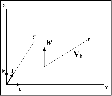
Vorticity is one of four quantities that are called the kinematic properties of fluid flow. The wind flow is described as a vector quantity; 2-dimensional vectors require two numbers to describe them fully; 3-dimensional vectors need three numbers, etc. Let us define the wind field as a function of position in a coordinate system; for simplicity, let the coordinate system be the standard 3-dimensional Cartesian system (x ,y ,z ), where (x ,y ) are the two horizontal coordinates and z is the vertical coordinate. Thus, since the wind vector V can vary according to its position in space, it is also denoted as V(x ,y ,z ). Vectors will be indicated in boldface characters. Let i, j, and k denote unit vectors of position in the 3-dimensional coordinate system (see Fig. 1),
Fig. 1. Illustration of the basic definitions of the wind in a 3-dimensional Cartesian coordinate system.
corresponding to the x , y , and z directions, respectively. The wind vector V, therefore, has three components: u , v , and w . We also can describe V as Vh+w k, where Vh is the horizontal wind vector and w k is the vertical wind vector.
For the horizontal (2-dimensional) wind, then, it takes two quantities to describe that vector. The mathematically correct way is to use the components I've already described and illustrated. However, horizontal wind also can be described in another way, that might be more familiar: wind speed and wind direction . When meteorologists describe the wind in this way, they refer to the direction from which the wind is blowing. A wind from north to south is called a northerly wind, for example. In Fig. 2,
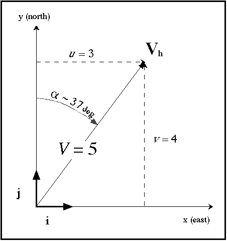
Fig. 2. An example showing two ways to define the wind: by (u,v) components and by speed and direction.
the components are u = 3, v = 4. This means that the speed of the wind is V = 5. The direction is shown as a ~ 37 deg ... but this is not the way a meteorologist would refer to it. Instead, the meteorological wind direction is described as b = 180 deg + a = 217 deg ... the wind is from the south-southwest. If 180 deg + a is greater than 360 deg (say a = 280 deg) then the meteorological wind direction b = a - 180 deg = 100 deg. As shown in Fig. 2, the wind speed and direction are related directly to the u - and v -components.[1]
Vorticity is a 3-dimensional vector, similar to the wind field itself. It's associated with the spatial variation of the wind field - the wind changes from point to point in space, but not all such changes produce vorticity. Since the 3-d vorticity is a vector, it has components, just as the wind does: If w is the 3-d vorticity vector then denote its three Cartesian coordinate components as (x,h,z). Each of the three components represents the vorticity associated with flow in a 2-d plane normal to the component. The x-component of the vorticity (x) is perpendicular to the y-z plane, the y-component of the vorticity (h) is perpendicular to the x-z plane, and the z-component of the vorticity (z) is perpendicular to the x-y plane. Positive values of the vorticity components follow the right-hand rule (see below). Details of this are found in Mathematical Diversion -1. Meteorologists, in general, are most accustomed to talking and thinking about the vertical component of vorticity (z).
Vorticity in its 2-dimensional forms results from two different types of wind variation: curvature of the flow, and differences in wind speed in a direction perpendicular to the flow. When looking at a 2-d vortex, it's easy imagine how the curvature of the flow produces vorticity, as in Fig. 3.
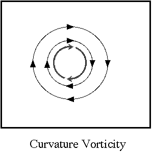
Fig. 3. An illustration of circular flow, showing the vorticity associated with this flow. The thin lines show the flow direction and the bold line indicates the sense of rotation associated with the vorticity. It is assumed that there is no shear vorticity in this flow, except at the exact center of the circular flow, where there is infinite shear (the flow must go to zero at r=0, implying an infinite vorticity).
For circular flow, at least, pure curvature vorticity is physically unrealistic (obviously). Real atmospheric vortices (in 2-d flow) have a combination of shear and curvature vorticity (see below).
However, as suggested by Fig. 4 ,
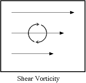
Fig. 4. An illustration of straight flow (no curvature), but with speed shear, showing the vorticity associated with this flow. As in Fig. 3, the thin lines show the flow direction and the bold line indicates the sense of rotation associated with the vorticity.
variations in wind speed can also produce vorticity. The figure indicates the sort of rotation that is implied by this form of wind shear, but the fluid need not actually be rotating this way. Fluids do not behave as solids do - imagine rolling a pencil in between the palms of your hand. Since a pencil is a solid object, it can only rotate between your hands. However, fluids have another "option" ... to see this, imagine pushing on a book that has been glued to the top of a table. What happens is shown in Fig. 5.
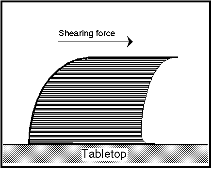
Fig. 5. Schematic showing the shearing action associated with a book, glued to a table top, subjected to a shearing force.
The pages of the book can slide past each other and the book is "sheared" without rotation. In a very similar way, the layers of a fluid can slide past each other when subjected to shearing forces. This produces vorticity in the flow, but without closed rotation!
Now, picture a 2-d Cartesian coordinate system that is set up such that one axis is aligned with the flow at some point in the fluid, and the other axis is perpendicular to the first. In meteorology, this is referred to as "natural" coordinates. The two different contributions to vorticity are easily seen in natural coordinates. The shearing contribution is shown in Fig. 6a, whereby vorticity arises from changes in wind speed V in the direction perpendicular to the flow (at the central point). The curvature contribution shown in Fig. 6b is derived from changes in wind direction a along the flow (at the central point).
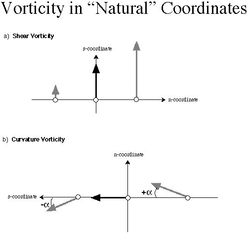
Fig. 6. Schematic in natural coordinates, defined at the point indicated by the small circle at the base of the dark vector; the s-direction is always pointed in the direction of the flow and then-direction is pointed to the right and perpendicular to the s-direction. In (a), the flow is straight, but speed increases to the right; in (b) the flow is curved but the speed is not changing in the direction of the flow.
It is most common for the 2-d flow to have both shear and curvature at the same time, so it can happen that the contribution to 2-d vorticity from shear is of the opposite sign as the contribution from curvature, just as it is possible that they have the same sign. In fact, as a special case, the flow can form a closed circle even though the total vorticity is zero! This happens when the shear term is of the opposite sign to, and is exactly the same magnitude as the curvature term. Even stranger, if the shear magnitude is large enough, the total vorticity could have the opposite sign to the curvature vorticity! Imagine a Rankine Combined Vortex (see Fig. 8, below). It is discussed in Mathematical Diversion - 2 that outside of the so-called Radius of Maximum Wind (ro) in the Rankine Combined Vortex, the tangential velocity decreases in proportion to 1/r, where r=the radius. The total vorticity outside of ro is zero because when tangential velocity decreases at that rate, the shear vorticity is of opposite sign to the curvature vorticity, and it exactly cancels the curvature vorticity. If the tangential velocity decreases with radius even faster than 1/r, then the vorticity outside of ro becomes negative! Thus, it's possible for a vortex to be rotating cyclonically throughout, with a cyclonic vorticity core and a ring of anticyclonic vorticity surrounding it. In fact, this is actually observed in the atmosphere in association with tornadoes and in the outflow region (aloft) of hurricanes.
For 2-d flow (say, at the surface), the vorticity vector points either up or down, perpendicular to the surface. The voriticity sign convention follows what is called the "right-hand rule": hold the right hand on the paper with the thumb in the "hitchhike" position; if the fingers on the right hand curve in the direction associated with the vorticity (as in Figs. 3 and 4), then when the thumb is pointing up, the vorticity is positive. If the fingers curving in the sense of rotation force the thumb to point downward, the vorticity is negative.
It's relatively easy to extend this concept to three dimensions - the 3-dimensional vorticity vector includes contributions from three mutually perpendicular surfaces: a horizontal surface (x , y ), and two vertical surfaces (x , z ) and (y , z ). The total 3-dimensional vorticity vector is the vector sum of these three. It also follows the same right-hand rule: if the right-hand's thumb points in the direction of the vorticity vector, the fingers curl about that thumb in a way that shows the sense of rotation produced by that 3-dimensional vorticity.
Consider the following example of the vertical component of vorticity (z), shown in Fig. 7.
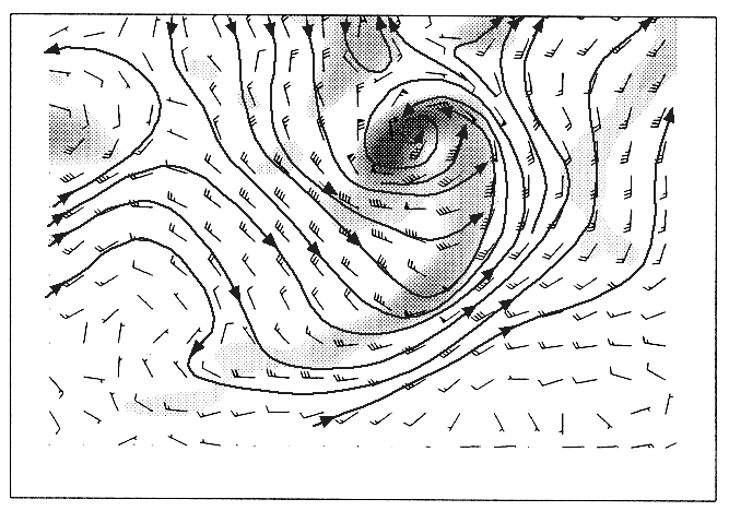
Fig. 7. A horizontal flow field, with the winds indicated by meteorological "wind barbs" instead of vectors. A positive vertical component of vorticity (z) is indicated by the stippling, getting larger as the stippling gets denser; the lines with arrows are subjectively-drawn streamlines (see discussion below).
Wind barbs are shown instead of wind vectors ... the notation is conventional. For this system, it can be seen that the peak vorticity is to the southwest of the center of circulation, where the curvature is high and the shear contribution to the vorticity is of the same sign as the curvature. Flow streamlines have been sketched in by hand ... streamlines are defined to be lines that are everywhere parallel to the wind (strictly speaking, they are everywhere tangential to the wind flow). Where the streamlines have high curvature, the vorticity is high owing to the curvature contribution. For instance, note the zone wrapped around the vortex where the streamlines make an abrupt turn; this coincides with a long zone of high vorticity (along a trailing cold front-like structure). On the other hand, to the northeast of the center of circulation (near the edge of the figure), there is a region of high vorticity due to the shear contribution. For these particular data, the shear term by itself does not create very much high vorticity, unless it coincides with contributions from the curvature term, whereas there are several vorticity maxima associated with strong flow curvature. This is not always the case, but depends on the flow situation under consideration.
A common problem in understanding the role of vorticity in flow curvature is that the vorticity field is what is called a Galilean invariant property of the flow. Simply put, Galilean invariance means that it you can change to any coordinate system moving with a constant velocity and it does not change the vorticity. However, the partitioning of the contributions to vorticity from shear and curvature is not a Galilean invariant property (see Viudez and Haney 1996). The amount of curvature we see in the flow can depend on the motion of the coordinate system.
To see this, consider the following simple example. Suppose we have a Rankine Combined Vortex, as shown in Fig. 8.
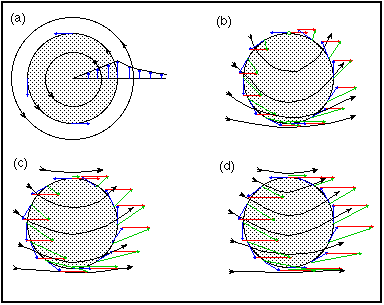
Fig. 8. Schematic showing the effect of adding increasingly strong constant background flows to a Rankine vortex. The vortex core is shown by the stippling, the blue arrows indicate the vortex flow, the red arrows denote the background flow, the green arrows show the sum of the vortex and the background winds, and the streamlines show the combined flow.
In this vortex, the flow is perfectly symmetric and circular, with contributions from both shear and curvature. However, in Fig. 8b, a background flow (that is constant everywhere) is added to the vortex, with that background flow being pure westerly with a speed equal to the speed at the radius of maximum winds in the pure vortex flow. Streamlines have been added to indicate the flow of the sum of these two. In Fig. 8c, the background westerly flow speed is twice that of that of the maximum vortex flow, whereas in Fig. 8d, the background westerly flow is three times that of the maximum vortex flow. If considered in a coordinate system traveling with the background flow in Figs. 8b-d, all the flows would be identical to that of Fig. 8a. However, it can be seen that by adding this background flow, the curvature of the resultant flow in a fixed coordinate system (i.e., not moving with the background flow) decreases as this background flow increases. In all cases, the vorticity remains the same, because the background flow has no vorticity!
In situations with mesocyclones as seen on a Doppler radar,[2] it is common for the flow in a ground-relative sense to be very asymmetric (perhaps with stronger inbound flow than outbond flow or vice-versa), because the vortex is moving. For a moving vortex, the flow on the side of the vortex that is going in the direction of storm motion, its ground-relative flow is the sum of the vortex flow and its motion. On the opposite side of the vortex, the flow is the difference between the vortex flow and the motion, so it is relatively slower. In a coordinate system moving with the vortex, the vortex flow typically is much more symmetric.
I already have defined streamlines to be lines everywhere tangent to (i.e., parallel to) the wind flow. Remember that most meteorologists are accustomed to dealing with the vertical component of the vector vorticity. However, the vertical component of the vector vorticity typically is the smallest of the three components.[3] That is, the variation of wind with height usually is much larger than the variation of wind along a more or less level surface (like on a surface of constant pressure). The horizontal part of the vorticity has two components, just like the horizontal wind has two components. Like the wind vector, the 3-dimensional vorticity vector is dominated by its horizontal part whenever the flow field can be said to be in near-hydrostatic balance (as discussed in the Mathematical Diversion - 1). Therefore, it should be relatively easy to imagine a field of vorticity vectors that might look very similar to a field of wind vectors, but which in fact are horizontal vorticity vectors wh (which have both x- and y-components) derived from the wind. As shown in Mathematical Diversion - 3, the horizontal vorticity vectors are dominated by the vertical wind shear of the horizontal wind. In fact, under the hydrostatic assumption, the horizontal vorticity vector is very nearly perpendicular to the vertical wind shear vector. However, there is no guarantee what the relationship is between the direction of the horizontal wind vector on some surface and that of the associated horizontal vorticity vector, which depends on the vertical shear vector of the horizontal wind.
When the horizontal vorticity vector and the horizontal wind vector are parallel, the horizontal vorticity is said to be streamwise , and when they are perpendicular, the horizontal vorticity is said to be crosswise . When the horizontal wind and vorticity vectors are parallel but point in opposite directions (antiparallel), the horizontal vorticity is said to be antistreamwise .
As noted in Doswell (1991), the notions of helicity can be developed from this point rather easily. That is not the point of these notes. Rather, I now want to move on to the idea of vortex lines. If streamlines are everywhere tangent to the velocity vectors, it seems straightforward to draw upon this analogy and picture lines that are everywhere tangent to the vorticity vectors. From a strictly two-dimensional viewpoint, this is moderately interesting, but the real value comes from the realization that there also is a vertical component to the vorticity vector.
In the same way that streamlines point in the direction of the wind flow, the vortex lines point in the direction of the vorticity vectors. The same old "right-hand rule" applies: if the right-hand thumb points in the direction of the vortex line, the sense of rotation is given by the fingers of the right hand.
When it comes to tornadoes and mesocyclones in storms, we're considering the rotation about a vertical axis. That is, the vertical component of the vorticity is what's important even though, on large scales associated with a thunderstorm's environment, the horizontal component is larger. Mesocyclones and tornadoes are not synoptic-scale! Recall that I've indicated the vertical component is often much smaller than the horizontal component in situations where hydrostatic balance applies.[4] If we make the approximation that the storm inflow and updraft simply acts on the environmental horizontal vorticity, an interesting picture begins to emerge.
If the originally horizontal vortex lines can be tilted into the vertical by some mechanism, then the vortex lines develop a vertical component, and so the vertical component of vorticity can be changed simply by tilting of the existing purely horizontal vorticity. It's widely accepted that this tilting of horizonal vorticity is the primary mechanism for creating mid-level mesocyclones in supercells (e.g., see Brooks et al. 1994)
Suppose the flow is such that the low-level wind shear is producing only crosswise vorticity. For example, a pure change of wind speed with height (wind direction remains constant) produces only crosswise vorticity. This is analogous to the case shown in Fig. 5 with the sheared book. Vortex lines are all horizontal in the environment.[5] Such a case is depicted in Fig. 9.
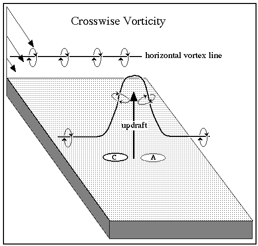
Fig. 9. Schematic showing the development of counter-rotating vortices on either side of an updraft from tilting the vortex lines associated with pure crosswise vorticity. Notice the sense of rotation indicated by the circles around the vortex lines, following the right-hand rule. This schematic is in the Northern hemisphere, where positive vertical vorticity is cyclonic , indicated by the "C" and negative vertical vorticity is anticyclonic , indicated by the "A".
On either side of the updraft, the vortex lines are tilted upward by the updraft, such that on one side of the updraft, a cyclonically rotating vertical component of vorticity is created. On the opposite side of the updraft, of course, an anticyclonically rotating vertical component of vorticity is found.
What happens when the vorticity is purely streamwise? This is illustrated in Fig. 10;
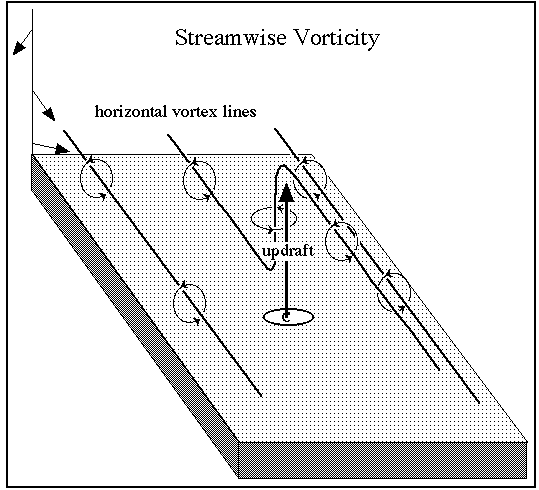
Fig. 10. As in Fig. 9, except that it is a schematic showing the development of a cyclonically rotating updraft from tilting the vortex lines associated with pure streamwise vorticity.
rather than producing a cyclonic-anticyclonic couplet of vortices flanking the updraft, what one finds is a helically rotating updraft. Note the difference between Fig. 10 and Fig. 9: the vortex line is shown going up in Fig. 10 but not coming down - this is an important difference between streamwise and crosswise tilting situations. A vortex line brought up in the updraft in the streamwise case eventually turns downward somewhere downstream, but this isn't shown in Fig. 10. It turns out that if we define some area on a horizontal plane, the vorticity about the vertical in that plane is related to the number of vortex lines inside that area. Thus, the more densely packed the vortex lines passing through some plane, the greater the vorticity. This is illustrated in Fig. 11, where the vortex lines are rather densely packed in one region as they pass through the plane.
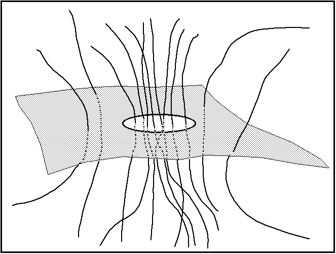
Fig. 11. Schematic showing vortex lines passing through a quasi-horizontal surface.
It's a law of fluid dynamics that vortex lines must form closed loops (Fig. 12). They can appear to terminate on a solid surface (as suggested by a tornado, for instance), but since the flow at a solid surface must equal zero (for a real fluid with finite viscosity), these vortex lines actually must diverge close to that solid surface and eventually loop back around on themselves - at least in principle. In a real, turbulent fluid, the picture is far more complicated than can be imagined.
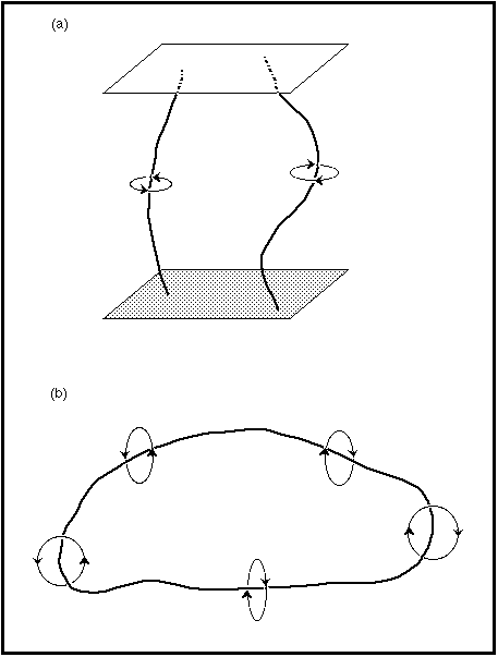
Fig. 12. Schematic showing (a) vortex lines "terminating" on solid surfaces, or (b) forming a closed loop.
This can have some interesting consequences in trying to picture the vortex line structures near the surface - as noted above, the flow can still have horizontal vorticity very near the surface (see Warsi 1993; p. 22). Thus, a vortex line approaching the surface in a viscous fluid must become increasingly horizontal. There are no other options, at least in the simple world of kinematics. This law has some pretty obvious implications for atmospheric vortices, such as mesocyclones and tornadoes. What we see as a funnel aloft (or a Tornado Vortex Signature [TVS] on a Doppler radar) does not have vortex lines that begin and end somewhere in the air - since that's not allowed, what must be happening is shown in Fig. 13.
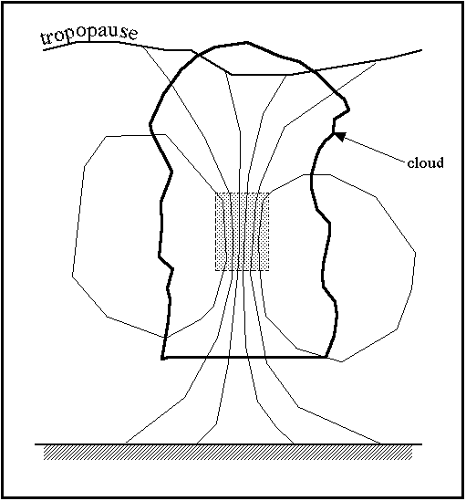
Fig. 13. Schematic showing the vortex lines associated with a TVS aloft.
The vortex lines that cluster somewhere aloft must diverge above and below the intense vortex, always forming closed loops but perhaps seeming to end near the surface. The figure also shows the vortex lines ending at the tropopause, but their actual behavior might be even more complex there than near the surface.
What we call "touchdown" of a tornado is actually an intensification of the vortex at the ground, which can be viewed as a clustering of the vortex lines. Nothing material is actually coming down as the tornado "touches down" - this process might more properly called a "spin-up" or "surface intensification." The intense part of a vortex aloft can build both upward and downward, as shown in Fig. 14.
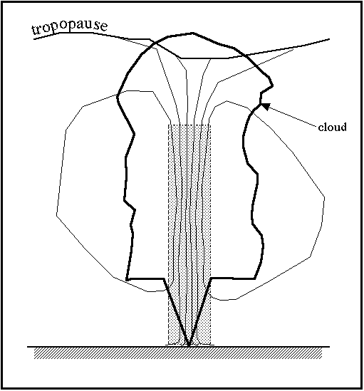
Fig. 14. As in Fig. 13, except that the vortex has intensified both upward and downward and now is a tornado.
Apparently, tornadic vortices can intensify first at the surface (Fig. 15) and then build upward.
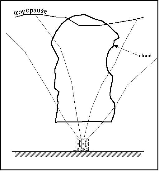
Fig. 15. Schematic showing vortex lines in a situation where the vortex intensifies first at low levels.
After some time period, Fig. 15 could evolve into something resembling Fig. 14; that is, it also can evolve into a tornado through a deep layer. Thus, the intensified vortex that we call a tornado might be seen to develop upward from the surface, downward from aloft, or both upward and downward.
Note: Comments and questions can be sent to me at cdoswell@earthlink.net.
Bluestein, H.B., 1992: Synoptic-Dynamic Meteorology in Midlatitudes . Vol. I: Principles of Kinematics and Dynamics . Oxford University Press, 431 pp.
Brooks, H.E., C.A. Doswell III, and J. Cooper, 1994: On the environments of tornadic and non-tornadic mesocyclones. Wea. Forecasting, 9, 606-618.
Doswell, C.A. III, 1984: A kinematic analysis of frontogenesis associated with a nondivergent vortex. J. Atmos. Sci ., 41, 1242-1248.
______, 1991: A review for forecasters on the application of hodographs to forecasting severe thunderstorms. Nat. Wea. Dig ., 16, No. 1, 2-16.
Viudez, A., and R.L. Haney, 1996: On the shear and curvature vorticity equations. J. Atmos. Sci., 53, 3384-3394.
Warsi, Z.U.A., 1993: Fluid Dynamics. Theoretical and Computational Approaches. CRC press, 683 pp.