This discussion is "conventional" in the way it describes the topic ... I am now of the opinion that this approach needs to be discarded, in favor of an approach that uses proper analogs with upright convection theory, and which uses proper terminology and diagnostic approaches. I think that the primary value of this "conventional" discussion now is in illustrating the conceptual tools used to explore instability, in general, rather than as a guide for application of the specific ideas embodied in "conventional" CSI. I recommend consideration of the revised concepts developed by Schultz et al. (2000), available here.
Most everyone knows about ordinary buoyant instability, sometimes incorrectly referred to as convective instability.[1] Basically, if a parcel is displaced vertically, when the atmosphere is unstable in this sense, the acceleration on the parcel is in the same direction as the displacement. From simple parcel theory, the relevant equation is the inviscid vertical equation of motion:
With appropriate manipulations, this can be transformed to:
where B is the buoyancy. Again, with some manipulations, this can be rewritten as:
where Gd is the dry adiabatic lapse rate and g is the actual lapse rate. This differential equation has the solution:
so that when the lapse rate exceeds the dry adiabatic, parcels are considered unstable. Note: this simple parcel theory has some serious issues, as discussed in Doswell and Markowski (2004), available here.
The existence of this instability means that in the real atmosphere, lapse rates exceeding the dry adiabatic are pretty rare, except very near the surface. Whenever superadiabatic lapse rates exist, it's pretty likely that convective overturning will occur and remove the instability, such that the lapse rate will be driven back toward the dry adiabatic.
In the presence of moisture in the form of water vapor, however, another option is present, the so-called conditional instability. It's called conditional because the instability depends on whether or not a parcel is saturated. A lapse rate g is considered conditionally unstable when it is between the dry (Gd) and the moist adiabatic (Gm< Gd) lapse rates.
In the real atmosphere, parcels become saturated during some sort of forced ascent, during which the parcels are normally negatively buoyant, so that energy must be supplied to continue their ascent. At some point (the saturation point) during their ascent, the parcels become saturated ... this is also known as the lifting condensation level (LCL). It is likely that the parcel is still negatively buoyant at the LCL, so the continued ascent typically still depends on the presence of forced lifting, but now the ascent is no longer along a dry adiabat. Rather, saturated ascent is along a moist adiabat. At some point above the LCL, the parcel ascent curve crosses the environmental curve; the crossing point is known as the level of free convection (LFC), above which positive buoyancy commences. This should all be familiar territory to convection afficianados and can be illustrated readily on a thermodynamic diagram. As it is typically applied, parcel theory involves finite displacements. However, the mathematical theory I've just given is associated with a differential equation and the notion of stability is defined in this theoretical context simply by the sign of (G-g) ... where G is either Gd or Gm - depending on whether or not the parcel is saturated. The implied displacements are infinitesmal. The sign of (G-g) is negative for saturated parcels in a conditionally unstable lapse rate situation, the square root produces a pure imaginary number and the time change of z becomes exponential growth ... bingo! ... it's unstable according to the simple theory.
Conditional instability means that for a saturated parcel, we replace Gd with Gm in our equation for z(t). Thus, whereas parcels ascending unsaturated are stable, parcels ascending saturated (hence, cooling at the moist adiabatic lapse rate, Gm ) are unstable, because Gm < g < Gd.
Consider what true convective instability means (see footnote #1, above). In a case where qe decreases with height, it can be shown that a parcel at the bottom of a finite layer (e.g., bounded by two pressure surfaces, p1 and p2<p1) will reach saturation sooner during layer lifting than will a parcel at the top of that layer. Continued layer lifting beyond that point where the lowest layer reaches saturation means that the top will be cooling at Gd, whereas the bottom is cooling at Gm. This differential cooling rate could increase the layer's lapse rate rather quickly. Continued lifting, however, would eventually bring the entire layer to saturation, so this destabilization associated with environmental conditions of convective instability does not continue indefinitely during forced ascent.
Is this what happens in cases of convection? This process is not likely to be an important one in real convection, where parcels from low levels are simply forced upward to their LCLs and eventually to their LFCs. The existence of true convective instability in situations involving real convection is typically associated with significant buoyant instability for lifted parcels, and the hypothetical process of lapse rate increases due to layer lifting in such cases is really not very physically relevant. In some relatively infrequent cases involving ascent of a layer (perhaps in an extratropical cyclone), this differential saturation rate of parcels in convectively unstable layers might be instrumental in an overall steepening of the lapse rate, but this simply makes ordinary, upright convection more likely.
If we consider a saturated displacement of a parcel, then if it ascends reversibly (i.e., the condensing moisture doesn't fall out but it retained in the parcel), it can descend along the same moist adiabat (i.e., the moist adiabat associated with the parcel's value of qe). [2] For a parcel rising in a conditionally unstable atmosphere, it finds itself positively buoyant for upward displacements and negatively buoyant for downward displacements, so it is easy to see that it is unstable. Clearly, when qe increases with height (the normal situation), the accelerations are opposed to the displacement, as illustrated in Fig. 1
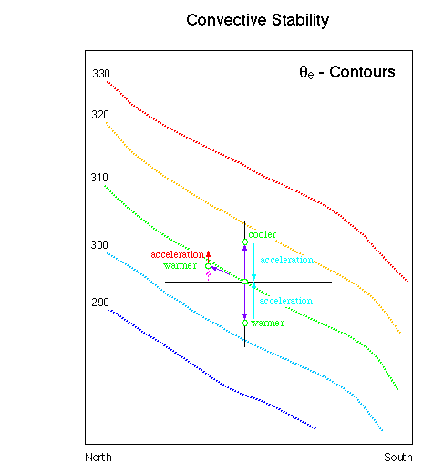
Figure 1. Illustration of convective instability. Parcel displacements are shown with the purple arrows, the acceleration for vertical displacements is shown in turquoise, the acceleration for a slantwise displacement is shown in red, and the vertical component of the slantwise displacement is shown as hatched lavender. The qe contours are colored such that warmer colors correspond to warmer qe values, but they also are labeled in deg K. In green, the parcel's state relative to its environment is noted: For an upward vertical displacement, for example, it is cooler than its environment, so the acceleration is downward.
Speaking physically, the force associated with convective stability is that due to gravity, so this might be called a conditional gravitational stability problem.
Now let us turn to inertial stability, a topic not necessarily as familiar to operational forecasters. Consider first the two inviscid horizontal equations of motion:
where f is the Coriolis parameter, (u,v) are the components of the horizontal wind, and (ug, vg) are the components of the geostrophic wind. Combining these into a single horizontal vector wind (V) equation gives
which means that the acceleration (dV/dt) is directed to the right of the ageostrophic wind. If the wind is supergeostrophic, the ageostrophic wind has a component in the same direction as the geostrophic wind, so the associated acceleration is directed toward the right (towards high pressure), whereas if the wind is subgeostrophic, the ageostrophic wind has a component against the geostrophic wind, so the associated acceleration is directed toward the left (towards low pressure). The effect of the acceleration is to return the flow to a state of geostrophic balance; supergeostrophic winds are reduced by being accelerated towards high pressue, subgeostrophic winds are increased by being accelerated towards low pressure.
In mid-latitudes, the wind through most of the troposphere is predominantly westerly (i.e., the u-component). There may be accelerations in either the u or the v component, but for simplicity, we can consider the flow to be defined by a basic state of pure westerly flow with perturbations in either u or v. We can define a quantity, then, known as the geostrophic momentum, mg:
where y is simply the local meridional coordinate. There is no corresponding y-component of the geostrophic momentum in the base state. In this base state, then, mg decreases northward (y increases) and upward (ug generally increases with height). Note that f increases northward.
Given this as a description of the basic state, consider Fig. 2. This illustrates the stability of horizontal displacements in a base state where geostrophic momentum increases upward and southward.
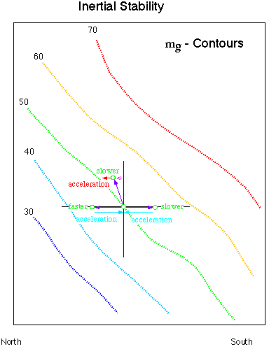
Figure 2. Illustration of inertial instability. Parcel displacements are shown with the purple arrows, the acceleration for horizontal displacements is shown in turquoise, the acceleration for a slantwise displacement is shown in red, and the horizontal component of the slantwise displacement is shown as hatched lavender. The mg contours are colored such that warmer colors correspond to larger mg values, but they also are labeled in m s-1. As in Fig. 1, the parcel's state relative to its environment is in green. For a northward displacement, it is faster than its environment, which means an acceleration southward.
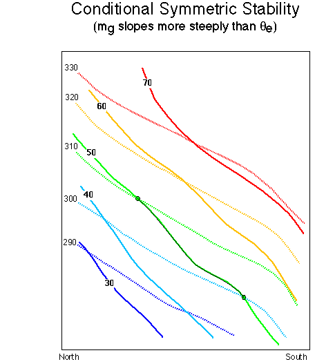
Figure 3. Illustration of the condition of conditional symmetric stability, with the qe surfaces as hatched lines and the mg surfaces as solid lines.
Again taking a physical viewpoint, the restoring force in this case is the Coriolis force, and this situation is a conditional dynamic instability.
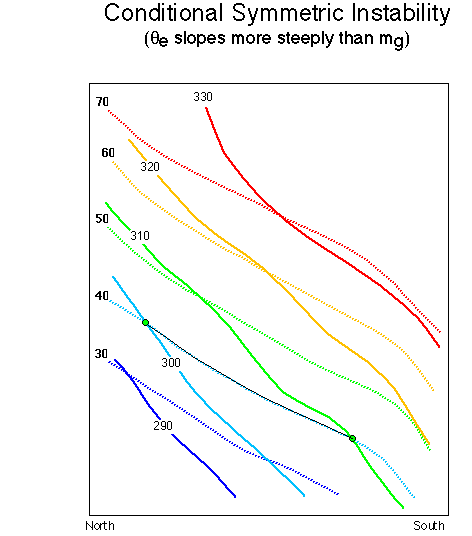
Figure 4. Illustration of the condition of conditional symmetric instability, with the qe surfaces as solid lines and the mg surfaces as hatched lines.
Finally, let us consider these situations combined. That is, we have an atmosphere that is stable to both vertical and horizontal displacements at the same time. This is illustrated in Figs. 3 and 4. Note, in passing, that the presence of horizontal thermal gradients makes this an instability associated with baroclinity. In a barotropic atmosphere, the isentropic surfaces (if any) are horizontal. Neither buoyancy nor inertial instability require horizontal thermal gradients, so symmetric instability is a type of baroclinic instability.
Basically, the question of CSI depends on how qe varies along a surface of constant mg. For saturated parcels (recall, the "condition" associated with CSI is that the parcel be saturated) moving along an mg surface, in the case of stability, they will find themselves in a region where their acceleration is opposed by buoyancy. As seen on the figure, parcels rising along the mg = 50 m s-1 surface find themselves negatively buoyant (in terms of qe ) and parcels sinking along that surface find themselves positively buoyant. This amounts to a restoring force and constitutes conditional symmetric stability . In this situation, qe increases with height along an mg surface.
On the other hand, as seen in Fig. 4, the condition of instability is associated with qe decreasing with height along mg surfaces. The situation now is reversed, so that parcels rising along mg = 40 m s-1 now find they have a higher qe than their environment, with the inverse true for descending parcels.
Unfortunately, CSI is (at least for the moment) a "fashionable" topic. Thus, it has a tendency to appear in forecast discussions in inappropriate ways. When the stratification is convectively unstable (the qe contours have a negative slope), the situation might well also exhibit moist CSI. However, in such cases, it is quite clear from theory and observation that upright convection would dominate any slantwise convection ... the growth rate of upright convection is considerably larger than that of CSI, so any CSI is overwhelmed. Strictly speaking, it is inappropriate to speak of CSI when the atmospheric is either convectively or inertially unstable. Only in cases where it is both convectively and inertially stable is it appropriate to speak of the possibility of CSI.
Further, not all cases of "slantwise convection" involve CSI. When parcels that are stable to purely vertical displacements are carried along slantwise paths, they may reach a point where they become positively buoyant. From that point, the convection is identical to ordinary, upright convection. Typically, this upright convection is "elevated" in the sense that the parcels participating in the convection do not originate in the boundary layer directly beneath the convection. Rather, they originate elsewhere and have followed a slantwise path to reach the point where they are positively buoyant. CSI is only one of many mechanisms that can carry parcels along a slantwise path; extratropical cyclones often do this poleward of warm fronts and frontogenetically-induced motions also produce slantwise ascent. The presence of weak symmetric stability is not sufficient to validate the occurrence of CSI, since convective instability is often associated with weak symmetric stability.
Thus, it is not true that CSI and "slantwise convection" are identical concepts! I believe the terminology here needs some careful thought and revision, to make it clear what is going on physically and to distinguish among the physical processes operating in any given situation.