Recently, I had an opportunity to review all my old video footage and obtain screen captures from those tapes. I thought it would be fun to include these in a review of old storm chases from the past. I also am including some slide scans, as a supplement. These are highlights from the time when I was not keeping a storm chase log, but using video. As time and opportunity permit, I'll add things from even earlier events (before 1987 ... my pre-video days). Although all the tapes from this period have been reviewed, I'm only presenting selected events, which were either tornadic or at least interesting from some viewpoint.
NOTICE .. Any duplication, electronic or otherwise, of the images at this Website without my expressed permission is a copyright violation, and I will treat it as such. Do us both a favor and ask me for permission before using any of the images herein ... you can e-mail me at cdoswell@earthlink.net.
NOTICE .. All images I show on my Web pages have been scanned from original slides or are screen captures, with some digital enhancement (touch-ups of dirt on the slides when scanned, and some enhancement of the original scanned images to make them look more like the original slides). I do not alter my images digitally to put in things that were not originally in the image or remove things that were originally in the image, and I do not make digital composites. I am personally opposed to such image manipulations unless they are admitted to clearly and obviously. For video screen captures, however, it has been my experience that they invariably need some help ... therefore, I have enhanced the screen captures to improve contrast and to try to re-create some of the original color balance and intensity (as best I can).
Rights to use my video can be negotiated with Martin Lisius Prairie Pictures / Storm Stock.
This chase was a good example of how sometimes you get lucky, and ... how chaser convergence works. Al and I spent a good part of the day struggling to get a handle on the day, and wandered about into and out of NWS offices (this was back when there were many more of them out there, although many of them were understaffed). We had been in the Abilene office, near the Abilene airport, without formulating much of an idea of where we were headed. When we left that office, we basically started chasing whatever was around. As we wandered about, we encountered what appeared to be a vigorously-growing towering cumulus cloud. Underneath that cloud, we observed the wind to be from the southeast .. then the east .. then northeast .. north .. northwest .. west .. southwest! This rotation of the wind took about 2 minutes or less. A closed circulation of sub-tornadic winds (about 10-15 mph) had passed over us. When we looked up, we were amazed to see evidence of that cyclonic swirl directly over our heads! From then on, we stayed with that cloud.
The rotating cloud was drawn into a larger, more substantial thunderstorm to the north-northeast of where we originally encountered it. As this cloud merged with the larger storm, it began to develop a rotating wall cloud, with the circulation increasing in intensity. We looked around and discovered that numerous chasers had converged from who knows where ... we were now in the midst of a mob of chasers (Tim Marshall, Roy Britt, Dave Hoadley, and others).
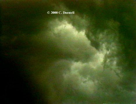
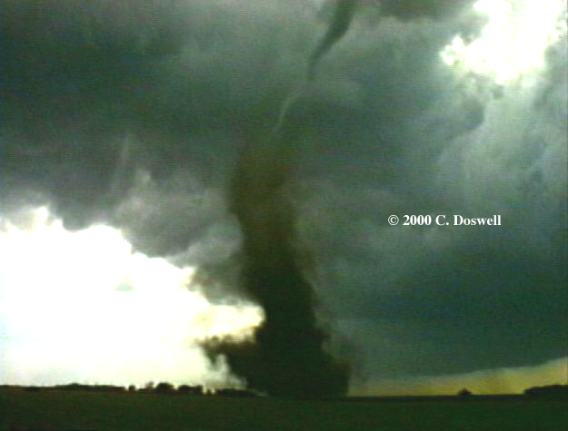
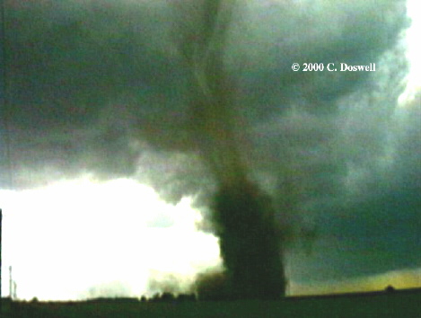
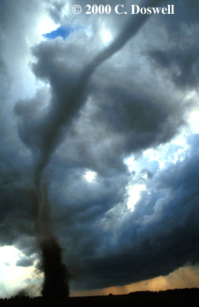
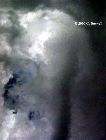
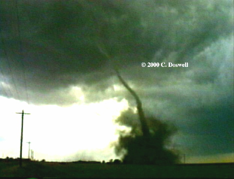
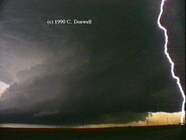
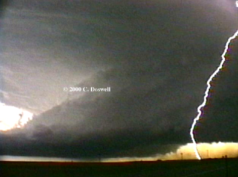
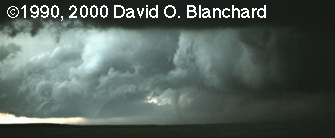
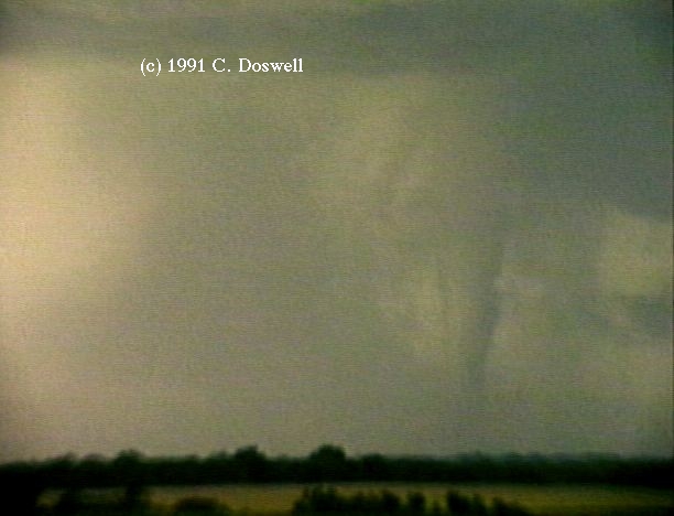
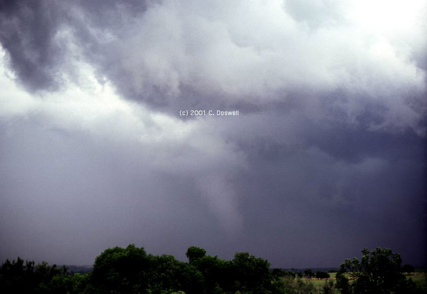
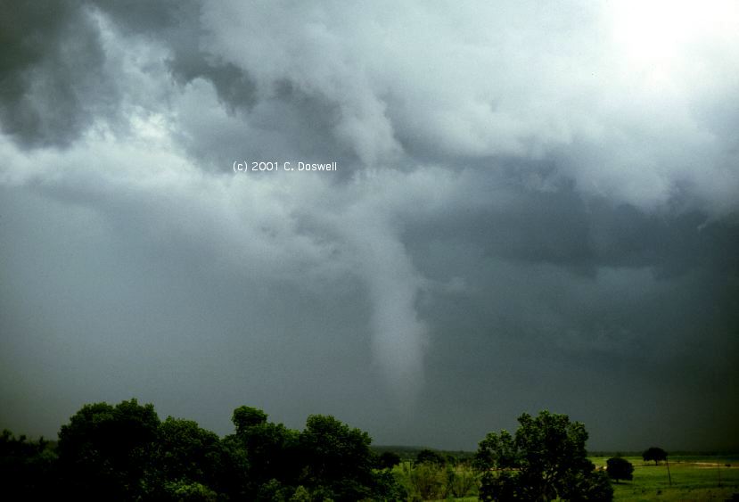
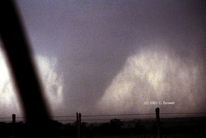
Suddenly ... debris! The tornado as yet had only a short, stubby condensation funnel, in spite of the rapid rotation at cloud base. The debris cloud tightened into what clearly showed a tilted tube, which then seemed to become more vertical. As it moved south (it was west of us, and so was moving right to left), the debris cloud became concentrated, with swirling motion very evident in it. Finally, a condensation funnel from cloud base appeared, developing downward to meet the debris "cloud" - at last, the snaky condensation funnel contacted the debris swirl. The tornado then seemed to be moving slowly from left to right. We were so close, I didn't have a wide angle lens that was wide enough to capture it all, although my 24 mm slide camera got about half of the total funnel ... I panned up to right overhead, where the funnel met cloud base. Panning down, I could see the spiral twisting of the semi-transparent funnel cloud - the funnel made a sharp turn as it approached the ground. Panning up to cloud base again, the swirl as the funnel merged with the cloud above it was spectacular. But regrettably, the tornado was dissipating - the video shows clear downward motion within the debris cloud, even as the remnant funnel inside it was still spinning.
With the dissipation of the tornado, which had put on a dramatic, Wizard of Oz - type show for us, the chasers suddenly dispersed. I was reminded of cockroaches in a room, scurrying for cover after you turn on the light. I hasten to add that I don't view my chase friends as "cockroaches" ... it was just an analogy for the dispersion! We hoped to see more tornadoes, with another supercell storm developing near Abilene, but it failed to produce a tornado.
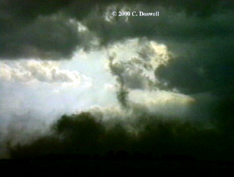
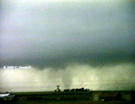
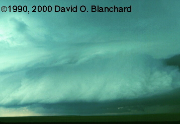
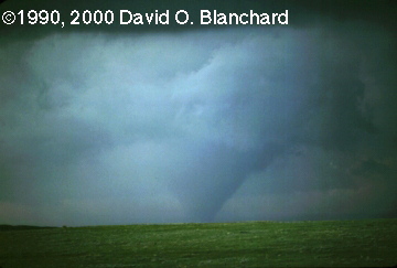
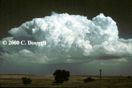
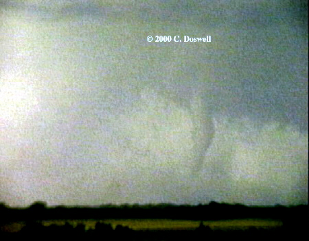
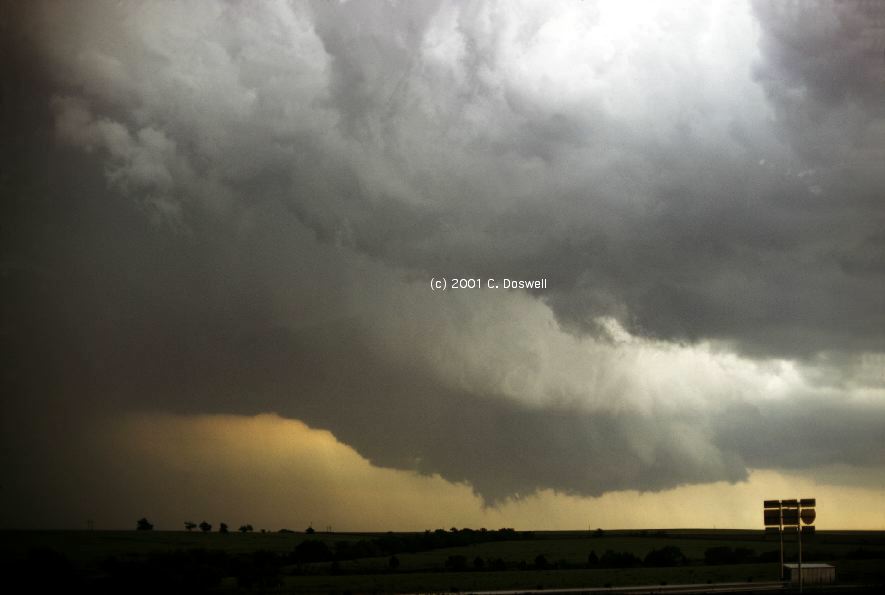
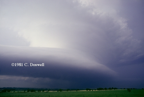
Another day wherein the early part of the chase was spent in mostly futile meanderings. We were plagued with a number of storms that developed between us and the "storm of the day" in our area, so we struggled with finding where to go. Finally, we got some radar information (I think Al found a phone and called his forecast office) or something, and we ventured south through Robert Lee, TX to find ... a beast. Now we would recognize this as an HP supercell. As soon as we got on the storm, it was already producing a tornado. We could see inflow bands and a beaver's tail toward the mesocyclone core. The first tornado seemed to dissipate, and another tornado formed, although it may just have been a continuation of the earlier vortex. The condensation funnel got very close to the ground, although the trees made it difficult to know just how close to the surface it was. The funnel continued as I unzoomed the image, showing the relationship of the funnel to the mesocyclone and beaver's tail (the latter was just out of the image to the right). This funnel continued to rotate and change, getting more vertical , and then gradually lifting. Further chasing resulted in no more tornadoes.
Gene Moore got onto this storm before we did and he saw more of what the storm produced ... see some examples of his images from this day here ...
For the third time in four days, we intercepted tornadoes ... this time was a situation with outflow and cool, moist air rushing upslope in the Texas Panhandle. The first storm we chased was intercepted north of Amarillo, and by the time we got to it, it had occluded and mesocyclone was undercut.
We heard there was another storm coming up to the west of Amarillo, so we roared off to the southwest, and first saw the storm west of Bushland, TX. Cloud bases were very low, and it was hard to tell just what might be going on, but it certainly looked promising.
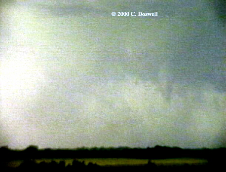
We let the storm get closer and ... tornado! The brief funnel was replaced by a tight debris whirl with no visible funnel cloud from the same place. This tornado dissipated quickly, to our frustration ... it caught us unawares.
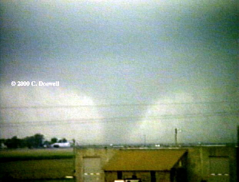
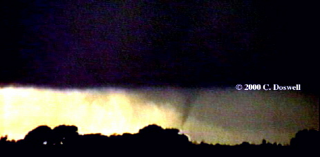
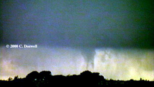
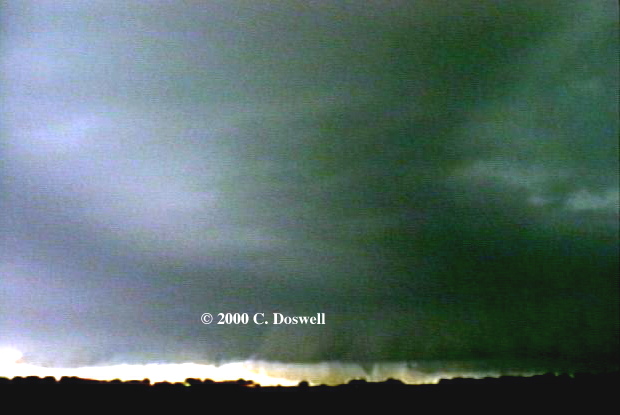
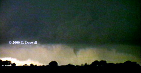
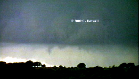
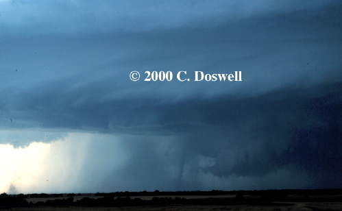
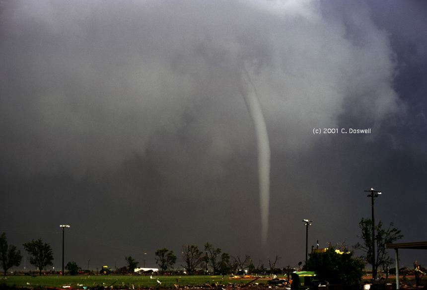
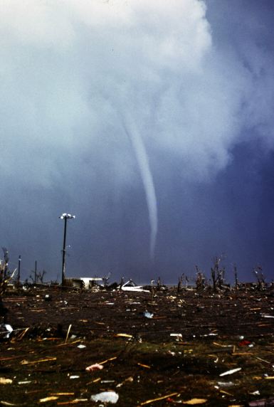
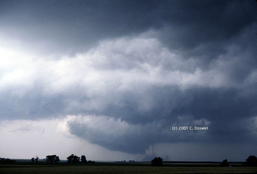
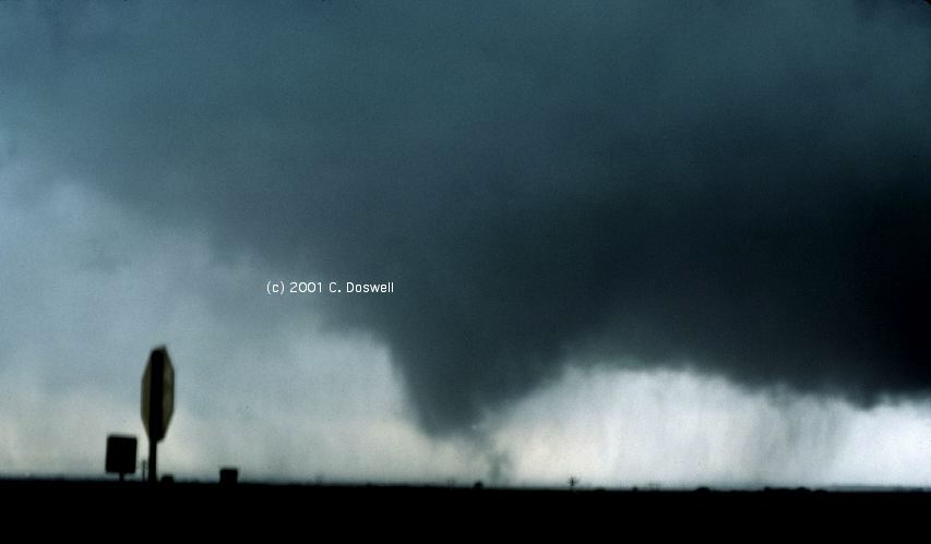
The storm, however, continued to move eastward and we stayed with it into the western outskirts of Amarillo. We got up on a bridge across I-40 at Coulter St. (as I recall), and ... suddenly the rain parted to reveal a large tornado ... this tornado was embedded in rain, and the condensation funnel was decidedly unsteady, forming and dissipating several times even as the violent rotation continued. The funnel took on various shapes and sizes here4, here5, here6, here7, here8, and here9 in the process, before finally disappearing in the rain, perhaps dissipating at some time when we couldn't see it.
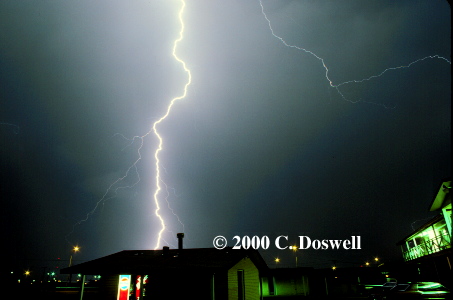
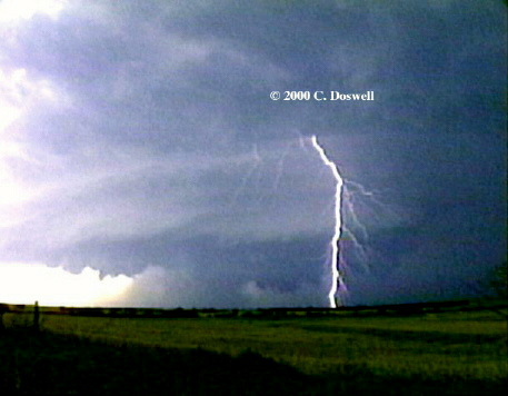
We then chased east, hoping to see more. Roaring up the slopes was a tremendous inflow, strong enough to produce a "drizzle storm" in the city of Amarillo. Driving past the airport, we saw planes taking off even though a tornado warning was out and a tornado had been observed only a few miles away! After much more chasing, we gave up as it got dark. In traveling south to LBB from there, I was fortunate to get a decent lightning shot in LBB from our motel.
There are six tornadoes in the relevant report: At 1620 CST, the first (rated F-0) tornado (1.5 mile path, 60 yards wide) was reported as a "gustnado" 3 miles southwest of Bushland ... this apparently was our first tornado. At 1635 CST, the second tornado (rated F-2) was reported by "storm spotters and research meteorologists" [that's us] 2 miles south of I-40 and 3 miles east of Bushland (a 10.0 mile path, 300 yards wide) ... this apparently was our big tornado. The third tornado (rated F-0) began at 1655 CST and had a 3.0 mile path, 50 yards wide, 12 miles northwest of Amarillo [reported by a Potter County Sheriff's deputy] ... at the same time that another, fourth tornado (F-0) was reported 6 miles southwest of Amarillo, having a 1.0 mile path, 40 yards wide, spotted by an "NWS employee". The fifth (rated F-0) began at 1702 CST (0.1 mile path, 40 yards wide), in western Amarillo. The sixth tornado (rated F-1) began at 1723 CST, also in western Amarillo (having a 0.2 mile long path, 110 yards wide). I have my doubts about a tornado 6 miles northwest of Amarillo while all this was going on south of I-40. I think that there were multiple reports of the same, occasionally large, tornado (the one we were watching), the funnel cloud of which was very unsteady and often rain-wrapped, during its extended lifetime.
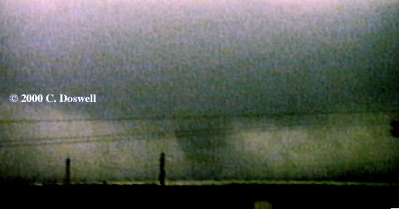
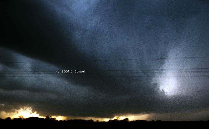
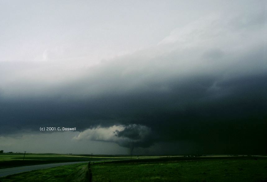
This one is painful ... chasing decisions were tough that day. We spent most of the day in GLD, trying to decide between two areas ... one near Russel-Great Bend, KS and the other near CYS in southeastern WY. After much indecision, we finally started moving ... on 1-70 toward DEN (for reasons that escape me!). As we got to LIC, the radio crackled with a warning from CYS, so we roared northward through the Pawnee National Grasslands in northeastern CO, meeting I-80 at Kimball, NE. Then ... westward ho! ... toward the storm we could now see to our west.
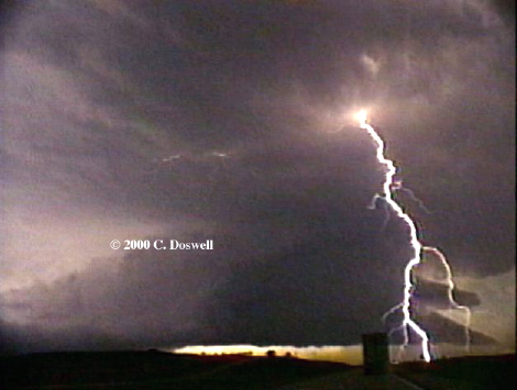
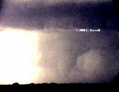
What a storm it was! It clearly was rolling up along the outflow boundary laid down by an earlier, now-dissipated storm. Going westward down I-80 ... suddenly, a tornado! We saw it so unprepared that my video was out of focus (sorry) ... it dissipated quickly. Although the tornado is tough to distinguish from the striated rainshafts in these screen captures, it shows up clearly in the rapid rotation on the video. The storm was a prolific producer of CG flashes from the anvil ... I have screen captures here4, and here5, and here6.
This case represented the ultimate futility in not making a chase decision. I would rather make a bad decision (and I certainly have since then) than make no decision at all, sitting in between my target areas (there often are two or more reachable target areas on a chase day), until it is too late. Hence, this day has been very influential in my storm chasing, since.
"...the largest single outbreak of tornadoes recorded in Wyoming history occurred on the afternoon and evening of the 24th in Laramie County. A regenerative severe thunderstorm complex was the culprit. A number of weak, short-lived tornadoes continually formed and dissipated ... "
In Laramie County (the county in extreme southeastern WY), from 1345 MST to 1830 MST, a total of 12 tornadoes were reported, including one F-2, with a path of 3-5 miles length, 150-400 yards wide, 25-30 miles northeast of Cheyenne at 1623 MST. It's possible that the last reported tornado, at 1830 MST, 3 miles south of Pine Bluffs, WY (very near the border with Nebraska) is the one we saw ... but the country shown in my video is not reminiscent of the Pine Bluffs area, which is somewhat hilly ... I think it's somewhere between Kimball, NE and Pine Bluffs, WY, and may be later than that reported time. Storm Data shows no tornadoes reported in NE on this day. Obviously, we arrived late and thereby missed quite a show, but Dave Blanchard graciously has sent me the following (please respect Dave's copyright!):
There are four images (cys1.jpg, cys2.jpg, cys3.jpg, cys4.jpg) taken at times of 1655, 1711, 1713, and 1716 MDT. All photographs were taken along US 85 northeast of Cheyenne at the Albin turnoff, looking to the W through NW.
For the record, in KS on that day, Storm Data shows 4 reported tornadoes, with the most significant being an F-3 (26.0 mile path, a mile wide), starting at 1610 CST. It began in Barton County (north of Great Bend), moved into Rice County, and ended in Ellsworth, County. Obviously, had we gone into central KS that day, we might have had a different sort of wild show!
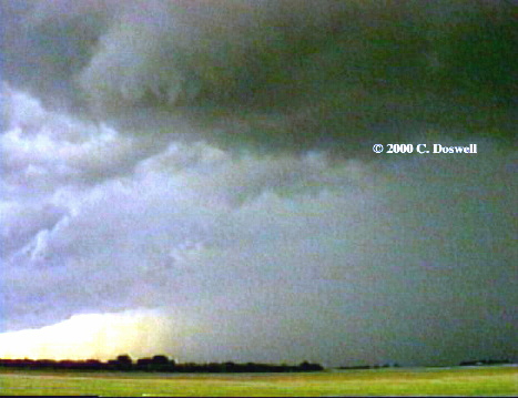
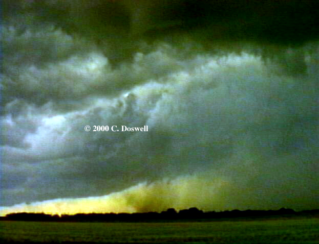
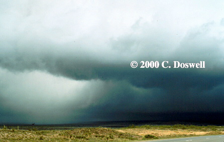
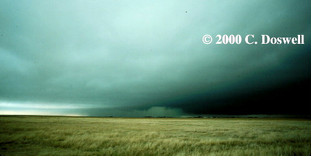
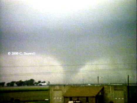
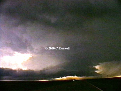
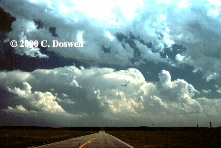
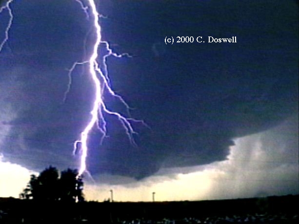
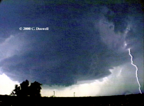
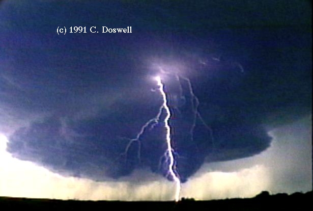
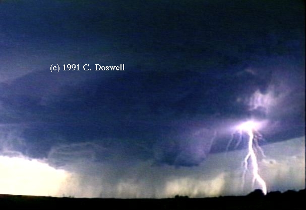
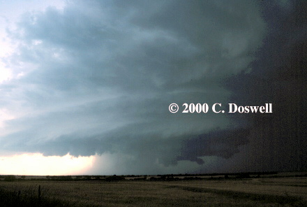
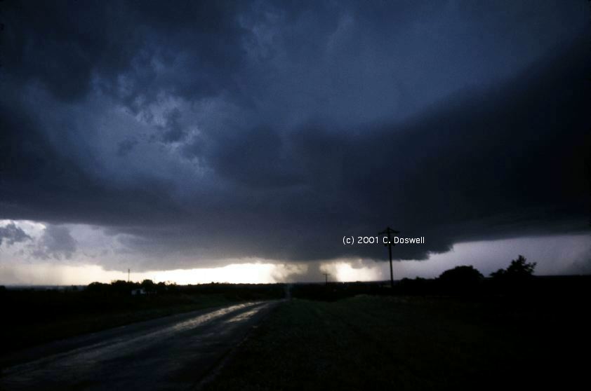
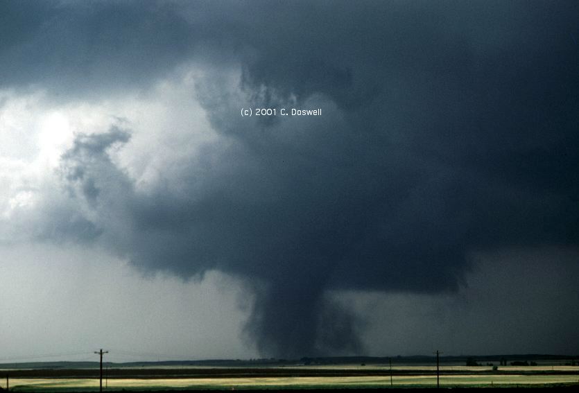
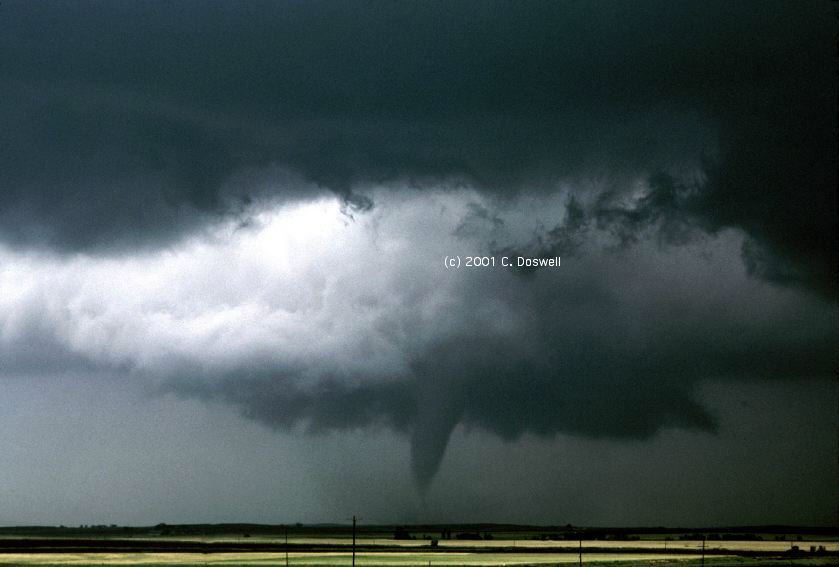
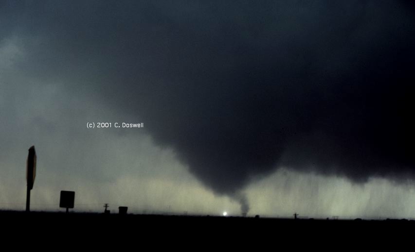
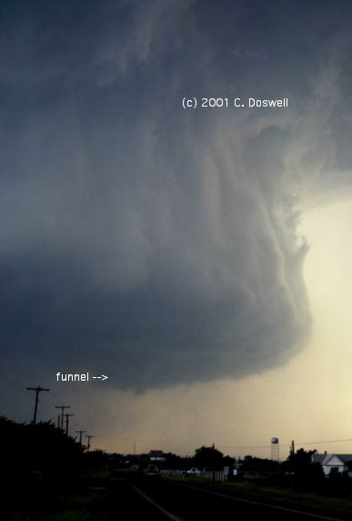
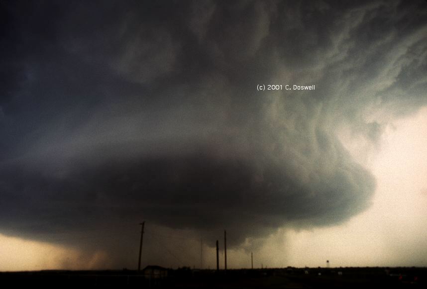
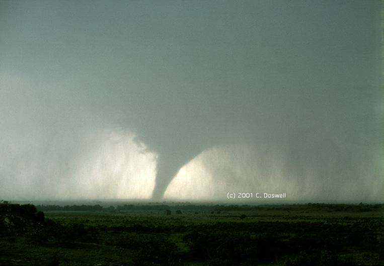
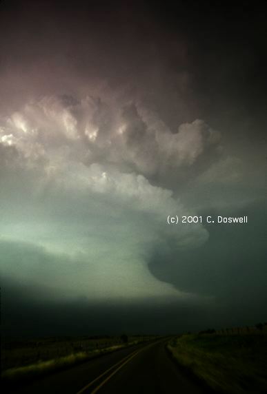
We had a good chase this day, starting in DDC and picking northwestern OK as our target. We drifted south, having what we felt was plenty of time. We saw some storms going up along the way, but we stuck to our chase decision and continued to push southward. Ahead of us, a storm was well along in its life, and as we drove into Woodward, OK, there were warnings out and we looked to get ready for what we felt was an eminent tornado. The storm had a gorgeous wall cloud, and CG lightning was everywhere ... from the anvil, from the vault area between the wall cloud and the forward-flank precipitation, from the updraft in front of the wall cloud, and even from the main lowering just next to the wall cloud. As we sat in ideal position just ahead of the wall cloud, we were mystified to understand why it was not producing a tornado ... we just sat for quite a while ... order 30-40 minutes, being peppered with CG lightning strikes and seeing rotation, but no tornado.
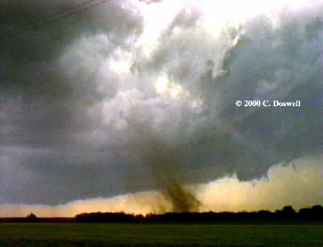
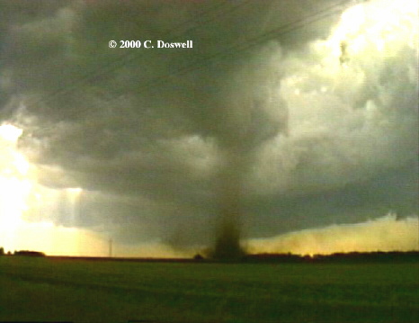
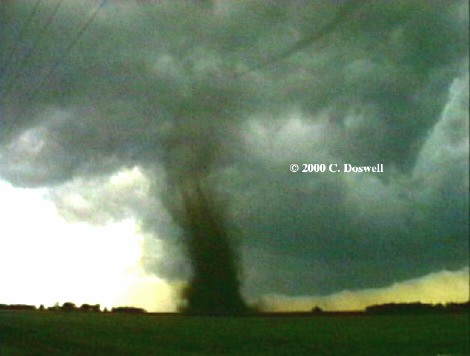
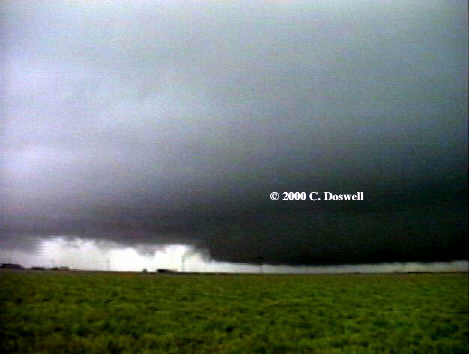
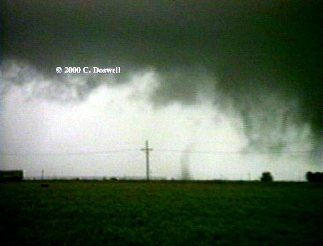
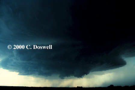
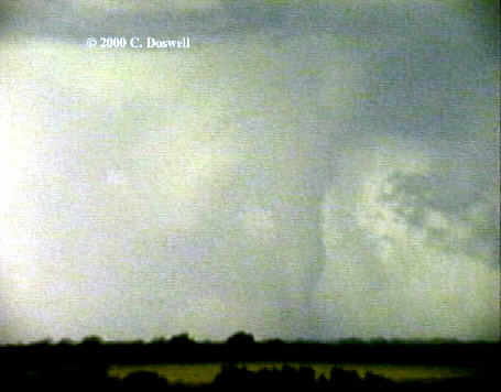
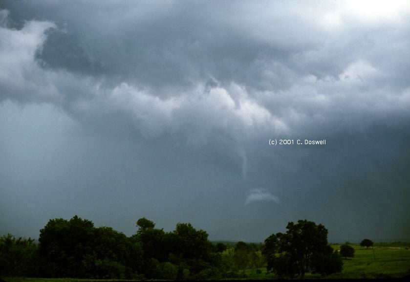
Finally, we decided to move because the storm was getting pretty close and we figured that if it was going to take this long, we might as well get well out ahead of the storm. Thus, we missed the chance for some real in-close tornado shots. However, we got a great view of the slowly-developing storm. [Note: given the contrast problem, the screen captures have required a lot of manipulation ... here is a somewhat more accurate rendition of the colors as we saw them, although even this is not perfect, either, since the slides also are contrasty and difficult to scan properly with my scanner.] There were several promising-looking lowering, including one that was wrapping around the storm and emerging from the left side of the precipitation shaft behind the wall cloud. As the precip fell away, we could see a large funnel! Although we couldn't see any debris, the funnel cloud got lower, until there was very little doubt that it had become a tornado. The rain continued to part, giving a more and more unobstructed view of the narrowing funnel. The "clear slot" was also becoming evident. At last, most of the tornado was clearly visible, and then it began to get distorted. Just before this time, a "gustnado" had developed well off to the left of the tornado and it appears after it had mostly dissipated here. As is often the case, the funnel's distortion signaled the beginning of the end, and the condensation funnel rapidly "lifted" and seemed to disappear. However, this was a bit of an illusion. Shortly thereafter, the standard "rope-out" became visible and the funnel was quite nice just before its true dissipation. The appearance of the funnel relative to the dissipating wall cloud is pretty dramatic.
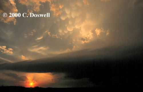
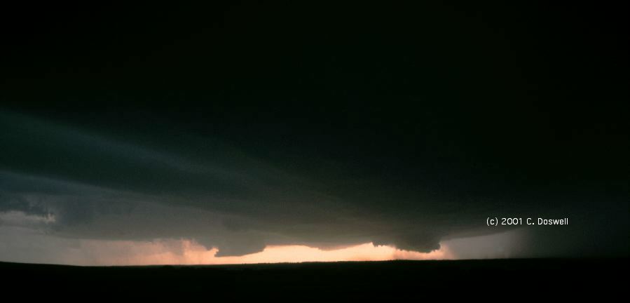
We continued to chase the storm ... but no more tornadoes! There was a nice scene of the storm at sunset, though.
Storm Data also reports a tornado (F-1 at1655 CST, 15.0 mile path, 400 yards wide) from a storm near Ulysses, KS .. it was intercepted by chasers (including Dave Hoadley) and the CAPS-91 intercept teams from NSSL (including the NOAA P-3 aircraft). The storm(s) near ICT are not given much attention in the Storm Data report, but Tim Marshall's video implies that the storm(s) produced several tornadoes. What I find interesting is that the Woodward area storm struggled long and hard to produce one significant tornado, whereas the ICT area storm captured by Tim Marshall on this same day was so prolific with tornadoes (although the individual tornadoes may not have lasted as long as the Woodward area event). What's the difference? I don't know but I'd sure like to know!
These are images from some of my most memorable early chase days. The slides are not as sharp or well-exposed as what I am now shooting ... I took a lot less care in getting good-quality images back in my early days of chasing. Nevertheless, the subjects are still interesting. If any of my colleagues want to correct any faulty memories that might have crept in, please let me know.
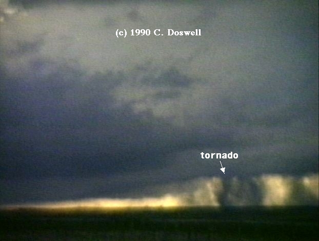
This was a chase done with the quasi-formal chase team put together in 1972. After driving westward to nearly the state border, we dropped south from I-40 on a 2-lane farm road to somewhere near Reed and Vinson, OK (west of Mangum, OK) based on phone input from Don Burgess, who was working the radar at NSSL that day. On the way, we drove through the rain and small hail our storm was producing. Once we were through that, my first clearly rotating storm was revealed and just somehow knew it was going to produce a tornado, which it did rather shortly after we first arrived and setup. I took some 16 mm time lapse footage of the storm and grabbed a few stills, one of which is here. It was a brief dust whirl seen under the obvious funnel, but which doesn't show up clearly in the slide. Not much of a tornado, but it was my first ever and I was most definitely ecstatic!
On this day, I chased with Al Moller, John McGinley, and Randy Zipser. We still didn't know much about chasing at this point. Early in the chase, we drove past the developing UC storm, noting that the convection was pretty impressive, but somehow not realizing what we were seeing. It was still a young storm, and I guess we had our eyes to storms developing to the north along the front. As we got up by Geary, OK, we called back to NSSL and Don Burgess told us that the storms we were headed for were junk (which we could see visually) but that the storm we had driven past was really starting to get interesting! We got back on I-40 and headed east to the US81 exit. Along the way, we stopped to admire some funnels dangling from the north side of the storm. Setting out again, we realized we would have to drive through the storm's precipitation to get to it. ... is this beginning to sound familiar? Anyway, as we approached the exit from the west, we could see a funnel developing from the wall cloud!! As we drove southward through the rain and some small hail, a tornado began to emerge from the murk. As we drove into town, the tornado was leaving town as a beautiful elephant trunk tornado. People were just then emerging from whatever shelter they could find, as we entered the town. Al Moller shot one of the greatest tornado photographs in history (in my opinion) with Randy Zipser's camera (making the copyright somewhat ambiguous!), looking down the damage path at the retreating tornado. The town had been hit pretty hard (the tornado was rated F-4) and damage was everywhere. I've already discussed the sobering effect this storm had on my fascination with tornadoes (see Item #32 here). As we watched, the tornado roped out, but at least we'd seen its beginning and end ... at the time, of course, we didn't know what we'd missed in between. Unbeknownst to us, Steve Tegtmeier and his first wife had driven leisurely to a vantage point where they could see the storm and its tornado. Steve Tegtmeier's shots were fantastic and achieved with much less effort than ours. The official NSSL chase team (I was a private chaser on this day!) also intercepted the storm and got stills as well as 8 mm and 16 mm movie footage. This case became famous because there were several chase teams on the storm from different angles, and we were able to relate our images to the NSSL Doppler radar. The day after, an extensive damage survey was done, and the rest is history.
This was a chase with Al Moller, Steve Tegtmeier, and Gene Moore (a rare event). It was a day with terrific lapse rates, enormous CAPEs and ... a strong cap. We waited around, not sure anything at all would happen. At about 3:30 pm CDT, we could see towers blowing up to the west from the roof of an OU building between the Meteorology offices and the Physical Plant ... we often used it to get a clear view. The chase was on. As we approached the storm (I think we were on OK9 between Anadarko and Carnegie), we could see some interesting things happening. The storm had a huge rainfree base, with two wall clouds and multiple inflow bands. Then, somewhat later as we got closer to the storm, from what appeared to be a precip shaft, suddenly we could see a dust-shrouded cylinder tornado! I was taking 16 mm movies again, and only had a few stills ... see Gene Moore's account for more images. It produced at least one more tornado, south of the first one that we saw. From our viewpoint, that next tornado was nearly transparent with backlighting, but from another viewing angle (we saw shots taken by a farmer, later), it was far from transparent. After that, we were cut off by the storm's precip - it was moving more southward than eastward, and even south-southwestward! After we lost touch with it, we heard about other storms (several tornadoes were seen near Frederick, OK) and were attempting to get to them when we crested a hill and ran into some standing water on the down side. Hydroplane City!! It scared the chase right out of us, and we went back to Norman, significantly sobered after a wild, exciting day. Our storm produced some pretty big hail, as well as 2-3 tornadoes. Later, we did a damage survey. This case was featured in my Ph.D. dissertation work, as well, so I have a soft spot in my heart for this chase day.
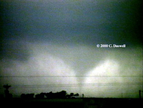
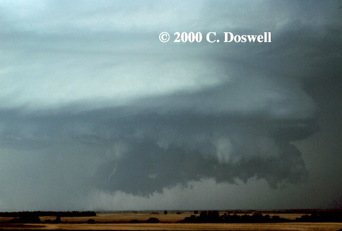
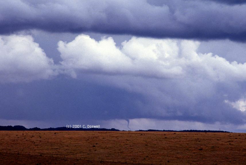
Late in the morning of this day, I attended the NSSL operational briefing, to be told by one of the NSSL "veterans" that it was unlikely to be a tornado day! Erik Rasmussen and I looked at the sounding that day and agreed that this was a bad forecast ... storms were going to rotate in Oklahoma that day! After that briefing, Al Moller and I got together and drove southwestward, along the turnpike (I-44) towards Lawton, initially. Once we emerged from the low clouds in central OK, we could see a tremendous storm to our north. We didn't know it, but it was the second tornadic storm of the day - an earlier storm had produced tornadoes, including one near Cordell, OK. We roared after it, getting more excited along the way. It had a great look as we were coming into it, with laminar flanking cloud bands feeding into tremendous convective bombs above! This image doesn't do justice to what we had seen earlier. As we got under it, it began to produce several "dust whirl " tornadoes (with no funnels). Then, as a clear slot wound around the wall cloud, a tornado occurred, from the south side of the wall cloud - this tornado rotated around the wall cloud as it evolved! Eventually, as it wound around to the east side of the wall cloud, the tornado began to dissipate. The ropey tornado moved around to the north side of the wall cloud before it dissipated completely. When that tornado dissipated, we tried to get closer to the storm. As we did so, another tornado dropped from the wall cloud, apparently near Alfalfa, OK. It was shrouded in dust for a while, but this gradually dropped away to reveal a nice tornado. This stayed on the ground for quite some time, and we had a great view of the tornado and the storm together and did not rope out, but rather turned into a funnel cloud that gradually "retracted" into the still-rotating wall cloud. Another tornado formed to our east, apparently from the flanking line ... I shot no images of that tornado, for some reason. A navigation error cost us a good view of the large, wedge tornado near Binger, OK, although we could see it in the distance. There were more tornadoes after that, including one we saw late in the day (after dark) from near Union City, OK. We chased the storm to near Edmond, OK that evening. All told, including dust whirls, we counted 12 tornadoes associated with that supercell (only six show up in the Storm Data record).
After the wild day we'd had on 22 May, it was with some pessimism that we chased the next day. We dropped south on I-35 into south-central OK and then moved east after developing storms began. After some misadventures (east of I-35) we thought the storm was "gusting out" but we stayed with it ... and experienced some warm downdrafts as what we now know as the RFD passed over us. To our east, suddenly, a tornado emerged out of the murky precipitation area ... initially it was a wide funnel shaped tornado, but as it moved away from the precipitation, it became cylindrical, and then became contorted, roping out with some wild kinks and gaps in the funnel. We thought 1981 might go on to be an incredible year, but after this day, no more tornadoes for the rest of the chase year. Still, two pretty decent days more than made the year.
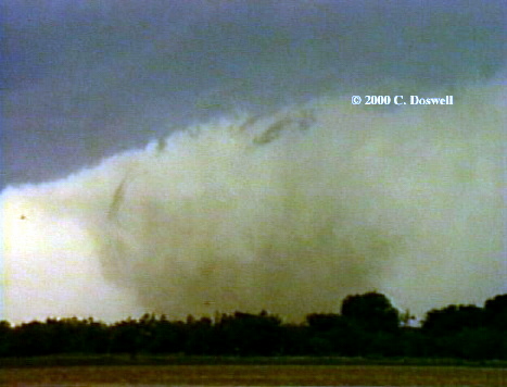
On this day, Al Moller and I were chasing together, and we figured out that the best chances for a good storm were near Wichita Falls (SPS). However, an early storm or two were already up, across the border in OK, so we decided to go after them first. On the way, we agreed to keep a SPS radio station tuned in and if we heard a severe thunderstorm warning, we'd drop south after it. Once in OK, we were joined by an early chaser "caravan" with lots of OU and NSSL chasers on the storm. Suddenly, on US-62 near Snyder, OK, Al saw a tornado! We were north of it, and it was a multivortex tornado. By some incredible luck, I snapped a shot just as it hit a power line. It moved away and was dissipating and becoming shrouded in rain. As we started to go after the storm, along with all the other chasers in the vicinity ... suddenly, on our SPS station came on with a severe thunderstorm warning!! That was our cue. We immediately began seeking ways to break away from the OK storm and drop south, which we did. After getting under the storm's anvil and driving through some rain and small hail, we emerged from the anvil precipitation and saw a rotating storm west of Archer City, TX. In Archer City, the storm was clearly getting its act together and sirens were sounding in town as it produced a funnel cloud over the town. As we headed east of Archer City, to stay ahead of it, it produced a tornado behind us, between Archer City and Windthorst, TX. The tornado lasted a good long time, eventually becoming a fat, but truncated funnel. The tornado dissipated after hitting Joy, TX. As we chased it eastward, never really catching it again, we got some great views of the structure. Gene Moore was also on this storm, unbeknownst to us, and had some interesting experiences. Phil Sherman was on the storm too, and got great shots of the storm structure, but could not see the tornado. This day is what convinced me to buy a video camcorder, because the ambience (sound and motion together) with this storm was just not capturable with still, silent images! Unfortunately, I had to suffer through the awful chase years of 1987 and 1988 before I could use the video camera for a tornado.
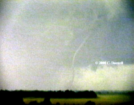
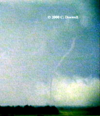
Some friends of mine (Hal and JoAnn Belknap) own property near Fort Davis, TX, and we are invited more or less every year to a get-together there over the Labor Day weekend. This is a very beautiful and relaxing place and we were sitting in their living room, when JoAnn exclaimed "Look there! It's a tornado, isn't it?" to which Hal replied skeptically, "Oh, JoAnn, please! It couldn't be." to which I replied "Oh yes it is! Where's my camera?" In the throes of an adrenaline rush, I fumbled my camera out and snapped some images of this distant tornado, which was somewhere between Fort Davis and Alpine, TX