Heavy precipitation has the potential to become hazardous virtually anywhere in the world, as witnessed by killer flash flood events recently in such diverse locations as mainland Spain (late November 1995), South Africa (January/February 1996), and North Korea (September 1995). It is arguably the most ubiquitous of hazardous weather phenomena, a potential weather disaster across most of the world's populated regions. Any investigation of the processes by which heavy precipitation occurs can be of value to weather forecasters, provided the study focuses on the physical processes giving rise to the intense precipitation. This study considers three cases from the set of five ANOMALIA[1] events that are of particular interest in the western Mediterranean.
The western portion of the Mediterranean Sea (Fig. 1) is that area enclosed by Spain, France, Corsica, Sardinia, northwestern Italy, Africa, and the surrounding lands (Meteorological Office 1962). This region frequently is affected by heavy convective rain, especially during autumn. Riosalido (1990) has shown that most of the heavy rainfall events in this area can be attributed to Mesoscale Convective Systems (MCSs), although they typically are relatively small in size and practically never fulfill the criteria for a Mesoscale Convective Complex (MCC) given by Maddox (1980). Thus, the majority of heavy rainfall in the region is convective in character.
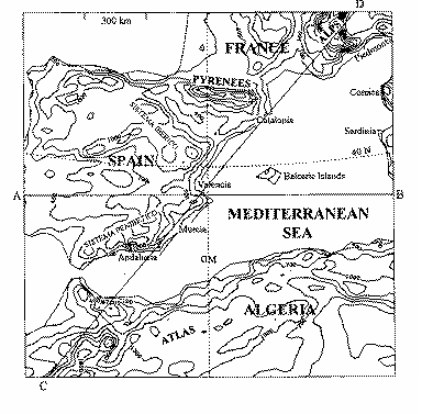
The western Mediterranean area has unique geographical aspects that can dominate local weather events. Figure 1 shows several topographic features of interest, as well as providing locations of specific sites mentioned in this paper. Notable among the topographic features are the Mediterranean Sea itself and the region's orography, including the Atlas Mountains of northern Africa, several ranges in mainland Spain (e.g., Sistema Ibérico and Sistema Penibético), the Pyrenees, and the western portion of the Alps. These topographic influences can play a large role in the structure and evolution of the weather systems associated with heavy precipitation. Along with the importance of the region-specific topography, certain common diagnostic tools are valuable for anticipating the possibility of heavy precipitation because they are based upon the appropriate physical processes.
Our basic diagnostic approach is to focus on the processes and parameters most directly and unambiguously related to the occurrence of heavy precipitation. This concept is developed at some length in Doswell et al. (1996; 1997), and is consistent with previous studies of heavy precipitation in the western Mediterranean region (see, e.g., Ramis et al. 1994).
Most of the data used in this analysis are from the European Centre for Medium-range Weather Forecasting (hereinafter, ECMWF). The data are provided on a 0.75 deg latitude/longitude grid at standard pressure levels. These gridded data are the initial fields used in the ECMWF numerical model forecasts. Since these data are specified on a grid at a fixed number of levels, a strict comparison between these data and a sounding is not expected to be perfect. The original data contain considerably more detail in the vertical, as might be expected, in comparison to the limited number of levels in the model, but the gridded data appear to be broadly similar to the observations.
There are at least two major advantages to using these as our primary data. First, the data have been defined on a computational grid, thereby removing the need to do an "objective analysis" in order to carry out diagnostic computations. Second, over the data-void regions, the model forecast combined with the limited observations provides a reasonable estimate of the field values. We believe that the benefits to using the gridded ECMWF analyses outweigh the possible drawbacks.
In order to have any significant coverage of observed rainfalls, it is necessary to use observations submitted by Instituto Nacional de Meteorología of Spain (hereinafter INM). These observations are only available as 24 h totals and so it is not possible to determine from them at what time within the 24 h period the rainfalls were concentrated.
The diagnosis emphasizes the spatial and temporal distribution of the mechanisms that at synoptic scales favor the development of convection. The main synoptic parameters are: 1) upward quasigeostrophic forcing for vertical motion (FQ ), 2) low-level (typically at the surface) moisture flux convergence, and 3) buoyant instability. Caracena and Fritsch (1983) and Doswell (1987), among others, point out that the identification of upward motion areas at synoptic scale using quasigeostrophic theory can provide important guidance in determining development zones of convective storms. Also, Barnes (1985) and Durran and Snellman (1988) show that the analysis of quasigeostrophic forcing of vertical motion can provide short-term guidance for the prediction of convective events.
Although convective (or potential) instability, defined as a decrease of equivalent potential temperature with height, is not strictly necessary for development of convective storms, it often is a useful diagnostic tool when combined with synoptic scale vertical motion (Iribarne and Godson 1981). What is required for convection is the existence of sufficient moisture and steep enough lapse rates for low-level parcels to become buoyant when lifted. Surface moisture flux convergence is another useful tool for identifying regions of upward motion in the presence of low-level moisture (Barnes and Newton 1986). As noted in Doswell et al. (1996), heavy rainfall requires the rapid ascent of moist air, and parameters like low-level moisture convergence have demonstrated their utility in diagnosing synoptic scale regions favoring convection for just this reason.
As important diagnostic parameters, we use the right-hand side of the [[omega]]-equation (see Hoskins and Pedder 1980), FQ, the water vapor flux divergence, Fw , the equivalent potential temperature, qe , the qe -difference between 500 and 1000 hPa, D qe , the Convective Available Potential Energy (CAPE), the mixing ratio, r , an average lower-midtropospheric lapse rate found by taking the temperature difference between 850 and 500 hPa and dividing by the thickness of the layer, and the storm-relative helicity of the environment. In order to address some issues related to the orographic effect, we have calculated a Froude number, Fr , and the component of the flow normal to the terrain, multiplied by the mixing ratio, r , to yields the moisture flux associated with flow normal to the terrain. All these parameters are described in detail in Doswell et al. (1997).
Finally, we have used a mesoscale numerical simulation model to assist with our diagnosis. This model is described in detail in Romero et al. (1996) and is based on the model used in Ramis and Romero (1995). It is a nonhydrostatic, primitive equation nested-grid model, with a terrain-following vertical coordinate. Both inner and outer grids use latitude-longitude coordinates with spacing of 0.75 and 5.0 degrees, respectively. The model uses parameterized convection, following the scheme developed by Emanuel (1991). It is initialized via a successive-corrections objective analysis and the analyzed fields are subjected to a mass-wind balancing before being used in the model.
Forecaster experience suggests that most heavy precipitation events in the Mediterranean have basically similar synoptic patterns, perhaps shifted eastward or westward from case to case. Case studies of important events confirm this superficial similarity. For example, García-Dana et al. (1982), Llasat (1987), and Ramis et al. (1994) show that the synoptic scale pattern for situations in the western Mediterranean region is characterized at low levels by an anticyclone located in the center of the European continent and a low to the west or southwest of Spain. This pattern produces advection of warm, humid air over the western Mediterranean. At upper levels, a trough (sometimes a cut-off low) is approaching the western Mediterranean region, while a ridge dominates the eastern part of the western Mediterranean. Ramis et al. (1994), through a study of the October 1987 flood case in Catalonia, show that a shallow, low-level cyclone often develops in the lee of the Atlas Mountains that drives the low level flow toward the Spanish coast (i.e., the development of the low increases the north-south pressure gradient, creating enhanced easterly flow). This fact favors the development of convection when that easterly flow gains moisture over the Mediterranean and then interacts with orography. Our two cases certainly have superficially similar synoptic structures, at least on the days when heavy precipitation occurred. However, as we shall see, the situations have many differences, as well as similarities.
a. "Algeria" case
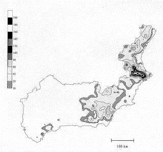
This case involves a series of heavy rainfall days associated with a slow-moving synoptic pattern. Precipitation occurred over an extended period (31 January - 06 February 1993) during this example, with particularly heavy 24-h rainfall totals on 01 February in Valencia and Andalucia and on 02 February in Valencia (Fig. 2a, Fig. 2b, Fig. 2c). This situation is unusual in that it occurred during the heart of winter, whereas most heavy rainfalls in the region happen during the months of October and November (Font 1983). The synoptic situation was basically stagnant during the period, with embedded mesoscale structures that controlled the timing and location of the heavy precipitation, as we will show in the next section.
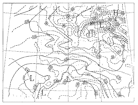
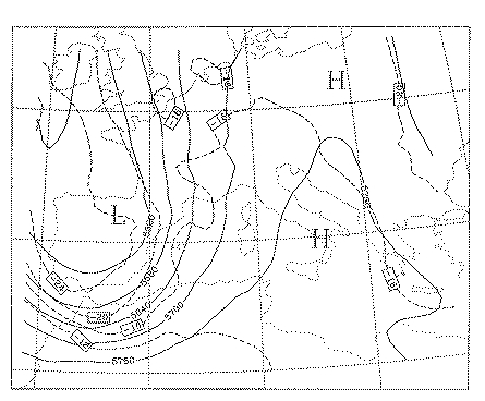
Figure 3 shows the basic synoptic situation on 02 February 1993 at 0000 UTC. A low-level cyclone can be seen (Fig. 3a) in northern Africa (Algeria) through much of the period. This low-level cyclone played an important role in the event; thus, our name for the case. The synoptic cyclone remained almost stationary throughout the period in this case, with the apparent center of circulation located south of the Iberian peninsula. The middle- and upper-level views of the cyclone exhibit a double structure (Fig. 3b), with two centers. Unfortunately, it is impossible to consider the diagnostics for the subsynoptic-scale features to be completely reliable; the data simply are too coarse and the systems are located in data-sparse regions where it is not possible to be completely confident of the analysis resolution (see Doswell and Caracena 1988). Our best method for detecting such features is animated loops of the satellite images.
During the several days of the event, the structures shown in Fig. 3 were present with only slight variations from day to day. Note that precipitation totals from the cooperative observations used in our isohyet analyses (Fig. 2) are valid from 0700 UTC on one day to 0700 UTC the next. Hence, the totals for "01 February" include amounts falling between 0000 UTC and 0700 UTC on 02 February. It appears that considerable convection developed in the Valencia region before the 0700 UTC reporting time, and continued well beyond that time. This is unfortunate, since at least some of the precipitation total for 02 February in Valencia probably includes a continuation of the rainfall that produced the large values on 01 February. Because virtually all of the rainfall observations are 24-h totals and because there is no available archive of radar data that could be used as an independent estimate of rainfall, there is no practical solution to this problem.
The precipitation in Andalucia is associated with a substantial convective system along a line of enhanced cloudiness that may be a reflection of a subsynoptic scale trough oriented roughly northwest-southeast. Animated loops of the satellite imagessuggest it is anvil debris from a series of small, warm-topped convective clouds forming offshore. The cloud line associated with the Andalucia convection rotates northward and may have played a role in the development of the convection that produced the heavy rains in Valencia. Convective development occurs near the axis of maximum qe at low levels; the fact that it is the cold season means there is not much CAPE available along the qe boundary. However, even a CAPE of 250 J kg-1 supports a pure parcel theory maximum updraft exceeding 20 m s-1.
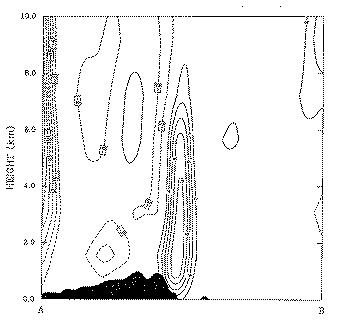
A feature of considerable interest during this episode is revealed by two cross sections (defined in Fig. 1). Along the eastern coast of mainland Spain, a deep vertical column of enhanced relative humidity with relatively dry air on either side persisted for days along cross section AB (Fig. 4a). The potential temperature distribution reveals by the spacing between isentropes that the plume is also in a region of low static stability. Along CD (Fig. 4b), it can be seen that this plume was concentrated along the southeastern Spanish coast, roughly corresponding to the region receiving the heavy rainfalls through the period 01-03 February. During this period, there was a tendency for the features of interest to move slowly north-northeastward, such that at the end of the episode, the precipitation was mainly in northern Valencia and Catalonia.
The FQ (not shown) for this event does not exhibit any obvious correlation to this persistent plume of high humidity along the coast of Spain. Overall, the nearly equivalent barotropic structure of the atmosphere in middle levels provided little clear signal for large-scale FQ . It is difficult to associate the plume of high humidity with any features in the FQ field. Flow fields at low levels were what one would expect in this overall synoptic pattern, with easterlies impinging on the coast of Spain, enhanced by the presence of the "Algerian" low-level cyclone. Minor day-to-day variations in the flow occurred through the period. The patterns of instability (not shown) reveal a slow increase in the CAPE values leading up to the heavy rainfalls, as well an increase in the areal extent of the positive CAPE through the first half of the period. The data indicate that this is clearly associated with a superposition of slowly increasing low-level moisture with regions of high lapse rate, as one might well expect (see Johns and Doswell 1992).
The end of the episode was associated with the movement of the synoptic scale cyclone to the northeast. As this happened, the zone of precipitation gradually moved out of the region and diminished in intensity, and the air over the Western Mediterranean became too stable to support further convection.
b. "Piedmont" case
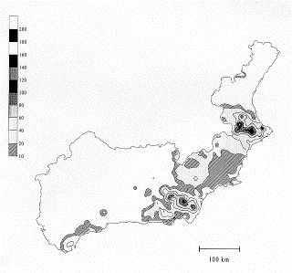
This second event is quite interesting, because the rainfall appears to be predominantly non-convective. Although rainfall was not limited to northwestern Italy, the majority of damage and casualties (6400 billion lira and about 65 deaths, according to Lionetti 1996) occurred there, in what is known as the Piedmont region (cf. Fig. 1); hence, our name for the case. Maximum rainfall amounts (Fig. 5) exceed 500 mm (19.7 in) in the northwestern portion of the area, close to the Alps. The spatial extent of the significant precipitation is large in this case. A strong synoptic scale trough is present, although the pattern is displaced eastward relative to the previous case, providing the threat further east in Italy and southern France, instead of the far western Mediterranean. A cold front can be seen clearly just to the east of Balearic Isles at 0000 UTC on 05 November. This front is the western boundary of a region of moderate CAPE, but the region of instability is primarily over Italy and the Mediterranean Sea westward from Sardinia to the Balearic Isles, with another maximum in central France.
Frontal movement across the Mediterranean is relatively slow, such that by 0000 UTC 06 November, the front is just east of the islands of Sardinia and Corsica. During this period, a strong jet streak moves through the base of the trough and the trough overall is lifting out to the east-northeast. The zone of synoptic scale forcing in the middle and upper troposphere is well upstream of the Piedmont region during the day of 05 November, still only approaching the region by 0000 UTC on 06 November (not shown).
Rather than explosive convective developments over the Piedmont region, the satellite images indicate a large, indistinct cloud mass moving over northwestern Italy with a secondary band still offshore by 0000 UTC 06 November. The low-level flow to the east of the boundary over Corsica and Sardinia is essentially southerly (Fig. 6a), providing a substantial upslope component over the foothills of the Alps in the Piedmont area (Fig. 7). At 500 hPa (Fig. 6b), a strong trough was moving eastward through the region during the day of 05 November; the FQ field (not shown) is associated with the secondary band of cloudiness, rather than with the heavy rainfall. Instead, it seems that the rainfall is being generated by orographic ascent. Heavy precipitation did not fall within a time span of a few hours, as is typical with a convective event. Rather, the rainfall persisted much of the day on 05 November, with average rates of perhaps 10-20 mm hr-1 (Lionetti 1996). This also indicates the predominantly non-convective nature of this event.
The heavy rainfall in the Piedmont region was forecast quite well by our mesoscale numerical simulation model (to be discussed in a forthcoming paper), and the model confirms that the precipitation in the Piedmont region was not convective in character. This is consistent with the basic synoptic pattern shown here.
a. Algeria
Although the synoptic pattern in this case seems to make the likelihood of precipitation relatively high throughout the period, a difficult forecasting challenge is associated with trying to localize regions of greatest threat in space and time. Much of the region ahead of the nearly stationary synoptic cyclone was characterized by weak quasigeostrophic forcing for upward motion, but the day-to-day changes in the location of the significant rainfalls do not seem to be related very well to synoptic scale processes. To some extent, the combination of the nearby modest FQ favoring upward motion and the favorable low-level moisture flow may have been sufficient to draw attention to Valencia. However, the excessive rainfall was quite confined in geographical extent, so large-scale concepts are not sufficient to anticipate these details.
Animated loops of the satellite images offer some insight, but it is not clear they provide simple, unambiguous indications of where and when the important convection would occur prior to its development. We have observed that a deep "plume" of high humidity air persisted for days along the southeast coast of Spain. It appears to have been important in the case. What are its origins?
Since we did mesoscale numerical model simulations of all our cases (as noted in section 2, the results of which will be reported upon in a forthcoming paper), the model forecasts have turned out to be helpful for understanding this event. Figure 8 reveals that the numerical simulation produced a "plume" of deep upward vertical motion that approximately coincides with the observed plume of high relative humidity (cf. Fig. 4). The simulation seems to have captured many of the details of the low-level flow (not shown), and it appears that the plume is a reflection of sustained upward motion induced by the interaction between the low-level flow and the orography. There is a reasonably good comparison between the model-simulated upslope flow at low levels with the observed precipitation (Fig. 9). Since the updraft peak is well above the terrain, the model indicates both a convective and an orographic component. A calculation of the Froude number (cf. section 2) yields Fr = 1.81, which suggests vigorous ascent and, presumably, enough lift to initiate buoyant convection.
The model results are not perfect, of course. Considering the scale and convective nature of the heavy precipitation, it is unrealistic to expect perfect forecasts, either by humans or by a model. The stagnant synoptic situation produced several days with very similar conditions. This allowed an initially dry and stable cool season airmass to be transformed gradually into one with modest CAPE, capable of supporting a few isolated heavy convective cells at an unusual time of the year for such events. The continued long fetch of easterly flow over a relatively warm ocean moistened the low-level air during its passage over the water and it was this moisture that produced the heavy precipitation. However, precisely where and when the precipitation would fall seems to have depended sensitively on the interaction of that low-level flow with the terrain. Slight variations in the flow at low levels could shift the focus to a different location. Thus, each day's heavy rain potential was high somewhere along the eastern Spanish coast during this persistent synoptic situation, but it appears that a very precise forecast of the low-level flow would be needed to obtain an accurate forecast of the specific location(s) of that day's heavy rainfall.
b. Piedmont
We have indicated that the rainfall in the Piedmont region was not primarily convective in character. Based on the overall pattern and the results of our mesoscale model simulations for the case, it appears quite clear that the rainfall is associated with upslope flow of weakly stable, moist air. For this case, the Froude number is much lower (Fr = 0.90), suggesting there might be some tendency for the upslope flow to be blocked by the terrain rather than going over it. However, for a saturated layer, the effective stability may be somewhat less than for unsaturated conditions and the satellite imagery certainly indicate considerable cloudiness. The low-level moisture values in the moist air impinging on the Alps is significant, even if the lapse rates are marginal for conditional instability. Hence, as in a case of heavy rainfall in the Kenai Peninsula of Alaska, presented in Doswell et al. (1996), the vertical motion associated with upslope flow appears to have been sufficient to produce significant rainfall in spite of the relative stability of the moist air. In the presence of steep terrain gradients and a large upslope component in the synoptic flow, the upward moisture flux is quite sufficient to produce substantial precipitation.
Satellite imagery indicates that storms clearly of a convective character occurred during the day of 05 November along the thermal boundary in the vicinity of Sardinia and Corsica. The cloud mass just inland from the coast in northwestern Italy might have contained some isolated convective elements, but the "fuzzy" nature of the cloud mass indicates that buoyant convection is not the dominant process. The occurrence of this precipitation in a region of marginally stable air at low levels suggests that even if some occasional lightning was occurring within this cloud mass (and we have no data to validate lightning occurrence), deep convection in the sense of buoyancy was not necessarily associated with that lightning. As noted by Colman (1990), lightning occurrence is not necessarily an indicator of purely buoyant ascent.
This set of cases reveals a number of implications for the meteorology of heavy precipitation in the western Mediterranean region. Our diagnosis of the cases varies from one event to the other because each event had different aspects to be investigated. This underscores a need to use physically relevant diagnostic parameters. Typically, but not always, this involves parameters relevant to deep, moist convection. Heavy precipitation in the region usually occurs in the autumn, since the Mediterranean Sea surface temperatures are still high from the summer heating while the onset of autumn increases the chances for strong synoptic forcing. As noted by Doswell et al. (1996), an important issue is the combination of rainfall rate and duration. With relatively large CAPE, strong updrafts yielding high rainfall rates. When CAPE is less abundant, the rates tend to be weaker, so the duration of the event must be larger to compensate for the decrease in the rate.
The processes by which the ingredients for heavy precipitation are combined vary from case to case. Even in the western Mediterranean region, where the synoptic patterns associated with heavy rain tend to be very similar, it would not be productive to follow a rigid set of diagnostic procedures. The all-important details associated with each case force the diagnostician to have access to a flexible set of diagnostic tools and to be able to recognize what tools are appropriate in any given situation. Our cases illustrate only some of the diagnostics that might be relevant for a particular case. However, the tools we have used are all related to the basic ingredients for heavy precipitation: rapid ascent of moist air.
The "Algeria" case represents a particularly challenging sort of event for forecasters. Since it is occurring at a time of the year when such events are rare, climatologically, forecasters should remember that the atmosphere does not read the calendar; when the weather patterns permit certain events, the calendar can only tell a forecaster he or she is dealing with an "unusual" situation, but being atypical is no protection against an event's occurrence. For this case, the stagnancy of the synoptic pattern is a key element; this permitted the gradual destabilization of the low levels, as air trajectories at low levels implied a long passage over relatively warm waters. Whereas Romero et al. (1996) have shown that on any given day, surface fluxes of sensible and latent heat may not be important for that day's convective events, over a period of several days, such fluxes can be very important in transforming the airmass. This airmass transformation, in turn, produced the potential for heavy precipitation.
However, the localization of the convection on each day appears to have been the result of subtle day-to-day shifts in the interaction between the low-level flow and the orography. Forecasting this would be quite challenging, and it is encouraging that the mesoscale numerical simulation experiments (to be detailed elsewhere) we ran for each case show some promise in providing guidance to forecasters.
The Algeria case also illustrates a serious handicap to operational assessment of the ongoing event: the predominance of 24 h total precipitation observations in lieu of hourly rainfall data. Whether or not the case has been forecast properly, if forecasters are to do a proper job of warning for a hazardous precipitation event, they must have abundant observations of what rainfall is actually occurring. Whereas 24-h precipitation totals make a post-event analysis such as ours difficult, it is unlikely that operational forecasters could even begin to deal properly with an event like this one without hourly precipitation data in real time. When lives are at stake, it is essential to have timely and adequate knowledge of what weather events are occurring if the forecasters are expected to issue life-saving warnings. Radar can be of tremendous value, of course, but nothing can take the place of hourly rainfall data.
The "Piedmont" case exemplifies a situation that forecasters in regions with complex terrain, like the western Mediterranean region, need to be able to anticipate: even non-convective precipitation created by persistent terrain-induced forced ascent can be dangerously heavy. The atmosphere does not care what mechanism lifts low-level moisture. If it is via forced rather than buoyant ascent, the result can still be heavy precipitation. In this case, both types of processes were operating at the same time, but in different geographical regions. The absence of buoyant instability is no cause for complacency with respect to heavy precipitation.
Like their counterparts in other parts of the world, convective storms in the western Mediterranean region respond to changes in their environment. Specific issues of interest to those studying heavy precipitation in the western Mediterranean region will almost always include the topography. The Mediterranean Sea itself and the complex terrain features surrounding it form a large topographic component in all three of these cases. In some sense, the combination of similar synoptic patterns and the importance of topographic features make the western Mediterranean region ideal for applications of mesoscale numerical simulations. When the orography induces mesoscale features (e.g., the "Algerian" cyclone to the lee of the Atlas Mountains) that play a role in an event, it is not only possible for a mesoscale model to anticipate such a development; human forecasters should also be aware of that potential and should learn to account for it in their prognoses.
Heavy rainfall events are always difficult to forecast because of the inherently quantitative nature of the prediction. Predicting the occurrence of rain is easier than predicting the amount of rain in any specific location. Nevertheless, it is expected of forecasters that they should be able to provide useful information about the potential for hazardous rainfall events. Three case studies do not allow us to make overly general statements, but the fact that virtually all documented heavy precipitation episodes in the region arise in superficially similar synoptic situations (e.g., Llasat 1987; Ramis et al. 1994) indicates pretty clearly that when the synoptic pattern includes a strong cyclone, especially one that exhibits "cutoff" characteristics, forecasters should be alert to the potential for hazardous rainfalls.
Although we have presented a case (the Piedmont event) where heavy rainfall occurred in the apparent absence of deep, moist convection, such a situation is not really representative of hazardous rainfalls in the Western Mediterranean.[2] Convection plays an important role in most such events in the region, so forecasting the occurrence of deep convection is a critical part of any precipitation forecast. Because of this, it is important to anticipate the development of CAPE prior to its actual appearance on a diagnostic chart by following the progression of moisture and lapse rate separately. Moreover, by monitoring low-level moisture separately, the potential for non-convective heavy rainfall can be assessed. Even when the ascent is orographically forced, there still is a need for substantial moisture content in the rising air.
As a final point of discussion, in the Algeria case, it is noteworthy that the satellite signatures associated with the case are much less impressive for the early convection in Valencia than for the convection further south. What is most relevant about the convection that produces heavy rain is its persistence, not its top height or the size of its cold anvil (see Doswell et al. 1996). For this case, the early convection on 1 February may not have produced the heaviest rainfall, but antecedent precipitation often is a factor in flash flood cases. This is by no means a new observation, but it is worth repeating: dangerous and important convective storms are not always the ones with the highest tops and the largest anvils. Just because a convective storm is small and has a warmer top is no reason to disregard it.
By considering three cases, we have begun a process to understand the complex meteorology of heavy precipitation in the western Mediterranean region. We have seen that whereas the synoptic patterns of all the cases have much in common, this does not make forecasting heavy precipitation easy and routine. Our diagnostics are focused on the rapid ascent of moist, low-level air, so we are interested in tools such as large-scale upward motion, buoyant instability, subsynoptic scale lifting, orographic lift (where appropriate), and moisture availability. When the evolution includes a severe thunderstorm (i.e., tornadoes, strong convective windgusts, and large hail) aspect that is relatively uncommon in the region. This suggests that even in the western Mediterranean region, forecasters have to be prepared to deal with a combined threat of severe weather and flash floods on occasion. Since deep, moist convection is common to both severe weather and most flash floods, a procedure that we can recommend is that outlined in Johns and Doswell (1992): first, diagnose the potential for deep, moist convection, and then consider the various types of hazards associated with deep convection separately.
Our set of diagnostic tools can serve as a starting point for dealing with heavy precipitation events anywhere. Assessment of the static stability is essential for at least two distinct reasons: it establishes the vertical motion response to a given amount of synoptic forcing (FQ ) and it distinguishes between convective and non-convective cases. In convective cases, it is typically important to try to establish where deep convection will commence and how it will move (see Doswell et al. 1996). Development is associated with subsynoptic scale processes (Doswell 1987) properly diagnosed with parameters like surface moisture flux divergence, provided the convection is based at the surface. For elevated convection, large-scale diagnostics like FQ may be the most useful. Forecasting movement of convective systems is challenging; we do not have any recommendation apart from saying that convective storm cells tend to move roughly with the mean tropospheric wind. For regions with complex orography, like the western Mediterranean region, upslope moisture flux is important in either convective or non-convective cases.
Clearly, two cases are not sufficient to make overly broad generalizations. We hope to be able to develop a synoptic climatology of heavy precipitation in the region based on a much larger set of cases than we have considered here. We want to know the frequency with which heavy precipitation episodes match the broad synoptic pattern that we have seen is common to all three of our cases (and others documented in the literature). Presumably, such a synoptic climatology would reveal other "recipes" for heavy precipitation than the three cases we have described, thereby indicating other diagnostic tools that might be needed.
Acknowledgments . This work was partially supported by EC under grant EV5V-CT94-0442. The lead author was visiting the UIB under grant DGICYT SAB95-0136. Meteosat images were generously provided by Prof. J. L. Casanovas of the University of Valladolid. Dr. V. Levizzani (FISBAT, Bologna, Italy) is acknowledged for his help with satellite image interpretation. Precipitation data were provided by INM of Spain.
Barnes, S. L., 1985: Omega diagnosis as a supplement to LFM/MOS guidance in weakly forced convective situations. Mon. Wea. Rev., 113, 2122-2141.
______, and C. W. Newton, 1986: Thunderstorms in the synoptic setting. Thunderstorm Morphology and Dynamics. 2nd Ed. (E. Kessler, Ed.). Univ. Oklahoma Press. 75-112.
Benet, C. (1986). Meteorological Data in Sabadell 1897-1979. (in Catalan). Ajuntament de Sabadell, Pl. Sant Roc 2, 08021 Sabadell, España.
Caracena, F., and J. M. Fritsch., 1983: Focusing mechanisms in the Texas Hill Country flash floods of 1978. Mon. Wea. Rev., 111, 2319-2332.
Colman, B. R., 1990: Thunderstorms above frontal surfaces in environments without positive CAPE: Part I: A climatology. Mon. Wea. Rev., 118, 1103-1121.
Doswell, C. A. III, 1987: The distinction between large-scale and mesoscale contribution to severe convection: A case study example. Wea. Forecasting, 2, 3-16.
______, and F. Caracena, 1988: Derivative estimation from marginally-sampled vector point functions. J. Atmos. Sci., 45, 242-253.
______, H. E. Brooks and R. A. Maddox, 1996: Flash flood forecasting: An ingredients-based methodology. Wea. Forecasting, 10, 560-581.
______, C. Ramis, R. Romero, and S. Alonso, 1997:
Durran, D. R. and L. W. Snellman, 1987: The diagnosis of synoptic-scale vertical motion in an operational environment. Wea. Forecasting, 2, 17-31.
Emanuel, K. A., 1991. A scheme for representing cumulus convection in large-scale models. J. Atmos. Sci., 48, 2313-2335.
García-Dana, F., R. Font and A. Rivera, 1982: Situación meteorológica durante el episodio de lluvia intensa en el levante español durante Octubre de 1982 (in Spanish), INM, 68 pp. Available from INM, Apartado 285, E-28071 Madrid, Spain.
Hoskins, B. J. and M. A. Pedder, 1980: The diagnosis of middle latitude synoptic development. Quar. J. Roy. Meteor. Soc., 106, 707-719.
Iribarne, J.V. and W.L. Godson, 1981: Atmospheric Thermodynamics. 2nd edition. Reidel Publ. Comp., 259 pp.
Johns, R. H., and C. A. Doswell III, 1992: Severe local storms forecasting. Wea. Forecasting, 7, 588-612.
Lionetti, M., 1996: The Italian floods of 4-6 November 1994. Weather, 51, 18-27.
Llasat, M. C., 1987: Precipitaciones intensas en Cataluña: Génesis, evolución y mecanismo (in Spanish). No. 40, available from Departament de Publicacions, Universitat de Barcelona, Avda. Diadonal 647, 08028 Barcelona, España, 543 pp.
______, and M. Puigcerver, 1992: Pluies extremes in Catalogne: Influence orographique et caracteristiques synoptiques (in French). Hydrologie Continentale, VII-2.
Maddox, R., 1980: Mesoscale convective complexes. Bull. Amer. Meteor. Soc., 61, 1374-138.
Meteorological Office, 1962: Weather in the Mediterranean, Vol. I, Meteorological Office, Bracknell, Berkshire, RG12 2SZ United Kingdom, 362 pp.
Ramis, C., and R. Romero, 1995. A first numerical simulation of the development and structure of the sea breeze in the island of Mallorca. Ann. Geophy., 13, 981-994.
______ S. Alonso and M. C. Llasat, 1995: A comparative study of two cases of heavy rain in Catalonia: Synoptic and mesoscale mechanisms, Surv. Geophys., 16, 141-161.
Riosalido, R., 1990: Characterization of mesoscale convective systems by satellite pictures during PREVIMET MEDITERRANEO-89 (in Spanish). Segundo Simposio Nacional de Predicción. Instituto Nacional de Meteorologica, Apatado 285, 28071 Madrid, España, 135-148.
Romero, R., C. Ramis and S. Alonso, 1996: Numerical simulation of an extreme rainfall event in Catalonia: Role of orography and evaporation from the sea. Quart. J. Roy. Meteor. Soc., (in press).
Figure 1. Map of the western Mediterranean region, showing major topographic features by means of terrain contours (interval 300 m, starting at 100 m), names of locations mentioned in the text, and the lines A-B and C-D depict cross sections discussed in the text and shown in Fig. 4.
Figure 2. Accumulated 24 h rainfall (mm) in Valencia, Murcia and Andalucia regions, a) for the period 1 February 1993 at 0700 UTC to 2 February 1993 at 0700 UTC, b) for the period 2 February 1993 at 0700 UTC to 3 February 1993 at 0700 UTC.
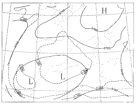
Figure 3. Meteorological situation on 2 February 1993 at 0000 UTC from ECMWF data. a) 1000 hPa, b) 500 hPa. Isohypses (dam) and isotherms (deg C) are shown as solid and dashed lines respectively.
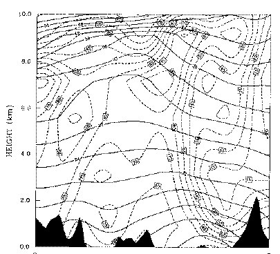
Figure 4. a) Cross sections on 2 February 1993 at 0600 UTC; a) along the line AB and b) along the line CD indicated in Fig.1. Solid lines represent potential temperature (deg C) and dashed lines represent relative humidity (percent).
Figure 5. Accumulated 24 hours rainfall in mm, for the period from 5 November 1994 at 0000 UTC to 6 November 1994 at 0000 UTC in the Piedmont region and southeastern France.
Figure 6. As in Fig. 3, except for 05 November 1994 at 0000 UTC.
Figure 7. Upslope moisture flux, rVt, for 05 November 1994 at 1200 UTC; isopleth interval 0.2 g kg-1 cm s-1, starting at 0.2 g kg-1 cm s-1.
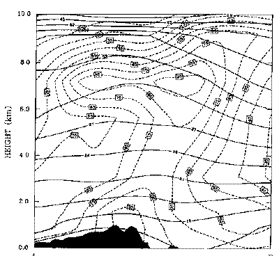
Figure 8. Cross section along AB (see Fig.1) of model predicted vertical velocity corresponding at 0600 UTC on 2 February 1993; the isopleth interval is 2 cm s-1 and solid lines indicate upward motion. The distance AB is 1800 km, so the width of the "plume" is about 150-200 km.
Figure 9. Model predicted upslope flow at the lowest atmospheric level corresponding to 0600 UTC on 2 February 1993; the isopleth interval 1 cm s-1 and solid lines indicate upward motion.