by
Posted: 9 August 2008 Updated: whenever
No news here - this is just more recent ideas, without much hard scientific substance. Any discussion of this, comments, or corrections can be directed to me at cdoswell # earthlink.net - click on the hyperlink to send an email or cut and paste the address after replacing " # " with an @ symbol. Click on thumbnail images to see them full size. Previous tornado musings can be found here and here.
NOTICE: I consider this entire document, including the figures, to be copyrighted material. Any reproduction of this content, in whole or in part, without my expressed permission is strictly prohibited by international copyright law.
In a publication about storm environments, Rasmussen and Blanchard (1998) defined the tornadic supercell (TOR) in the following way:
TOR: This category was designed to identify soundings associated with tornadic supercells. While some of the reports of tornadoes of F2 and greater damage intensity in 1992 possibly were associated with nonsupercell tornadoes, nothing in the database of severe
weather reports allows nonsupercell to be distinguished from supercell tornadoes. The justification for the exclusionof F0 and F1 tornadoes in TOR was to generally exclude nonsupercell tornadoes, as well as to filter some of the myriad of erroneous tornado reports (Doswell and Burgess 1988) that generally are given the F0 or F1 rating. The label TOR is used here mainly for convenience; the strict interpretation of the category is soundings associated with tornadoes rated F2 or greater.
When they made the distinction this way, I had some initial misgivings, but as time has passed, I've come to believe in this, for a number of reasons. In addition to filtering out many nonsupercell events, this concept also excludes what I believe to be a lot of very marginal tornado events from consideration, including nonmesocyclonic tornadoes produced by supercell storms, as well as gustnadoes misidentified as tornadoes. It also would exclude brief, weak "spinups" produced by a supercell that might well fit some criteria as true tornadoes. It's now my belief that many of the weak tornadoes reported in the database are produced by physical processes on scales well below what we could reasonably expect to be able to resolve via observations in the next 20 years or so. Although such a definition will erroneously exclude some real but misclassified events from consideration, perhaps because they occurred in open country, this is a relatively small price to pay for having a much greater likelihood for representing tornadic supercell environments. I'm concerned about this for reasons that I hope to clarify as I proceed with these musings.
One notion that I'm obviously very committed to is "ingredients-based thinking" - and in addition to forecasting, I believe it's important to understand physical events using the concept of ingredients. I'll not repeat the whole litany of background material associated with this concept - I'm currently working on a new publication summarizing my use of the term "ingredients-based" so please be patient. In the mean time, see Doswell et al. (1996) for an earlier summary of the notion.
Consider the three types of "severe weather" as recognized officially by the National Weather Service in the USA:
Note that waterspouts are not logged as tornadoes officially unless they come onshore, for reasons that escape me. SPC lead forecaster Jack Hales (1993) first proposed adding another layer to these definitions: significant severe weather events, defined as:
When this new category of severity was proposed, it made sense to me. Thresholds are arbitrary, of course, but it seems logical to distinguish relatively marginal events from those that are pretty obviously important. I'm not going to repeat here all the caveats associated with the databases regarding severe storm reports. See Brooks et al. (2003) and Doswell et al. (2005), as well as their references, for more information.
It's long been obvious to me that the ingredients for these different forms of severe weather aren't necessarily the same. A discussion of the basic physical reasons for this can be found in Doswell (2001). Based on some recent findings by my NSSL colleague, Dr. Harold Brooks, it's becoming increasingly clear that if only CAPE [or its proxy, the maximum vertical motion (wmax) associated with that CAPE derived from pure parcel theory: wmax = (2*CAPE)1/2] and vertical wind shear (0-6 km) are considered as forecast parameters and only significant (hereafter abbreviated as "sig") severe weather events are considered, the different severe weather events are distributed quite differently on a 2-dimensional diagram of CAPE and shear. Dr. Brooks' research is still in progress, but he tells me that given the occurrence of a sig severe event of any sort, a number of things can be determined:
Please stay tuned for more findings from Dr. Brooks as he proceeds with this fascinating research. Personally, I don't find these results particularly shocking. In fact, they seem consistent with my ingredients-based understanding of severe weather: different events are associated with different ingredients. What produces one type of event (say strong convective wind gusts) need not be associated with the production of the other two (very large hail and tornadoes). Of course, a few storms produce all three types of severe weather, but in the context of all severe weather reports, they're relatively rare. From a forecasting perspective, a parameter useful for forecasting wind likely need not be very helpful for forecasting hail or tornadoes. SPC forecasters now routinely use this notion in formulating their Day-1 probabilistic outlook product, which depicts the separate probabilities for each type of severe weather event.
As discussed in Doswell (2001), the ingredients for producing strong convective wind gusts are associated with factors controlling downdraft strength (see also Wakimoto 2001). The ingredients for producing large hail are not so well-known as those for convective wind, but clearly include factors controlling updraft strength (see Knight and Knight 2001). The ingredients for producing tornadoes (see Davies-Jones et al. 2001) are at least as poorly-known as those for hail, but recent understanding (e.g., Markowski et al 2002) has made it evident that supercells producing sig tornadoes are not very likely to be producing extensive cold downdrafts. It appears that a reasonable environmental proxy for the strength of the downdraft is the height of the lifting condensation level (LCL) or the average low-level relative humidity (temperature-dewpoint spread) - see Thompson et al. (2003) or Doswell and Evans (2003). Further, the low-level shear (e.g., 0-1 km or even lower - see Esterheld and Giuliano 2008) appears to be an important parameter for both sig and nonmesocyclonic tornadoes (see here for more on this)
For several years now, it's been understood that sig tornadoes occur over a wide range of shear and CAPE values, but it seems from the preceding (and studies such as Monteverdi et al. 2003) that CAPE is not very helpful in discriminating tornadic from nontornadic enviroments. This raises a question in my mind about what tornadic supercells are doing to their environment that differs from what nontornadic storms (supercellular or otherwise) do to their environments. And that topic, in turn, relates to a favorite topic of mine: for what does the atmosphere need tornadoes?
A big concern with parameters related to severe storm forecasting is that even if most of the relevant ingredients are brought together, an event doesn't necessarily ensue because sometimes no storm develops at all. The challenge with initiation is that the primary issues are the strength and depth of the stable layer capping the planetary boundary layer and the strength, depth, and duration of any upward vertical motion needed to lift potentially buoyant parcels to their levels of free convection (LFCs) - see discussion in Doswell (2001). Too much capping and/or not enough ascent and nothing ensues. However, if the capping is too weak or the ascent too powerful, too many storms can develop, precluding the occurrence of relatively isolated supercells. It's a case of the "Goldilocks problem" - the combination of capping and ascent has to be just right. Generally speaking, when storms initiate too soon, the available potential energy is leaked off before it has time to build up. Unfortunately, both capping and vertical motion are difficult to observe and the reanalysis fields produced by the ECMWF and NCEP tend to be too coarse, especially in the vertical, to produce a reasonably accurate diagnosis of either capping or vertical motion. Hence, any attempt to represent these using reanalsysis data is likely doomed, which is why Dr. Brooks has not attempted to do so.
In the USA, CAPE and shear environments favorable for severe weather occur more frequently than the actual occurrence of sig severe weather. If it were possible to represent the likelihood for storm initiation within the overall parameter space, this bias could be reduced. Work to do this awaits the development of a parameter derived from reanalysis data that can accomplish this. Although proximity soundings can be used to diagnose convective inhibition reasonably well for a few events, the vast majority of severe weather events can't be represented by a reasonable proximity sounding owing to the sparseness of the sounding network in both space and time. Nevertheless, it seems plausible to surmise that some capping is good for the development of severe storms because it allows the reservoir of available energy to build up and then be released explosively. Unlike the tropics, where it seems that the development of conditional instability is followed almost immediately by the initiation of deep convection (that rapidly restores the environment to a near neutral equilibrium state with respect to moist adiabatic ascent), in midlatitudes, the energy represented by departures from equilibrium are "stored" and may be released days and hundreds of kilometers from where they were created. In fact, in midlatitudes, it's not easy to decide what is a proper equilbrium state to impose. For the development of steep lapse rates, insolation within dry air masses produces nearly dry adiabatic lapse rates - this is relatively far from a moist adiabatic equilbrium state, but it's not obvious that moist adiabatic equilbrium is meaningful in midlatitudes. An equilibrium state for this problem should represent a minimum of available potential energy for severe convection, but in midlatitudes, there are many distinctly different environments without much available potential energy for convection. Moreover, the wide variablity of moisure content in midlatitudes (which have much more continental land area than the ocean-dominated tropics). Among the tropical landmasses, the Sahara is a perpetual desert, whereas northern South America land can be viewed as a "green ocean." In any case, the uncertainty of convective initiation in midlatitudes makes it possible to manufacture available potential energy by differential advection (which implicitly requires vertical wind shear) over a period of days, resulting in very intense convection when this reservoir is released. The release of that energy typically takes place far from where it was created, both in space and time - for instance, the moisture being processed in deep convection over the Plains in the USA may have evaporated from warm ocean waters days and thousands of kilometers removed from that storm.
Interestingly, the research by Dr. Brooks suggests that CAPE-shear environments in Europe capable of producing severe weather are much more likely to produce that severe weather than comparable environments in the USA. Apparently, as environments evolve toward favoring severe weather, storm initiation in Europe is much more likely than in the USA, on average. Since his research is based on reanalysis data, Dr. Brooks has yet to find a way to account for capping and other factors that would affect storm initiation, so it's not yet possible to confirm the reasons for the increased frequency of storm initiation in Europe. However, that relative ease by which environments in Europe produce severe storms might be important in affecting the frequency of CAPE values comparable to those in the USA. In other words, it may be that in Europe, because deep convection ensues more readily during the processes producing CAPE, this lowers the frequency of CAPE values exceeding, say, 1500 J kg-1 there. This, in turn, might be a factor in the overall lower severe convective storm frequency in Europe.
Although by no means universal, some tornado outbreak days (e.g., 08 June 1974, 26 April 1991, 23 May 2008) are characterized by a large number of tornadic supercells that form over the course of the event, followed by an intense squall line that sweeps through the same region previously affected by as many as dozens of supercells.
![]()
An example of a "clearing" squall line to the west of a number of tornadic supercells during the evening of 23 May 2008. This line eventually swept through all of Kansas and northern Oklahoma, evolving into an MCS and putting an end to convection for the day.
The passage of the squall line generally ends convective activity for the day. The interesting aspect of this is that apparently a sizable number of very intense supercell storms doesn't seem to diminish the potential for new convective storms to develop, whereas the "clearing" squall line pretty much shuts down such activity. Thus, it seems that isolated storms with powerful updrafts and only weak to moderate downdrafts don't modify the environmental conditions so as to preclude convection - that is, they don't seem to reduce the environmental CAPE very effectively. Squall lines, on the other hand, seem to be very efficient in overturning the atmosphere and consuming the CAPE. Could it be the case that the main role for supercells isn't so much to reduce the stored convective available potential energy (CAPE) reservoir - although it certainly must do that to some extent - but is rather more concerned with modifying the vertical wind shear so as to reduce whatever "potential" energy reservoir is associated with that vertical wind shear. Strong, long-lived squall lines, on the other hand, don't seem to be very dependent on vertical wind shear (contrary to the claims of so-called RKW theory - see Evans and Doswell 2001). Unlike supercells, such squall lines can develop in environments with very weak shear (as in the tropics) or very strong shear and anywhere in between - but like supercells, they can develop in enviroments with little CAPE, as well as very large CAPE, and anywhere in between.
In my 2006 musings that preceded this, I mentioned the apparent value of the product of the CAPE and vertical wind shear, rather than the quotient (as in the so-called Bulk Richardson Number - BRN). Sig tornadoes from supercells can arise when the CAPE is anywhere from a modest value to very large values, so long as a reasonably large vertical wind shear is present. I noted that in this diagram
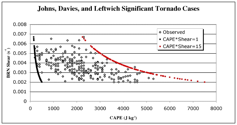
Data from Johns, Davies, and Leftwich (1993), with added hyperbolas for the CAPE-shear product = 1 and 15 J kg-1 s-1 -- "Observed" values are the 100 mb surface layer-based CAPE (no virtual correction) and the so-called BRN shear (surface to 6 km) values from 238 cases of F2 and stronger tornadoes.
environments with both extreme CAPE and extreme shear at the same time are apparently not observed with sig tornadoes. This begs the question - is this because those environments simply don't occur, or is it because when they do occur, they don't produce sig tornadoes? Dr. Brooks has found that in general, environments with both extreme shear and extreme CAPE at the same time occur with a lower frequency than you would predict if you treated CAPE and shear as completely independent random variables. I believe it likely that there are physical reasons why CAPE and shear tend to avoid this part of the diagram. It seems that the atmosphere doesn't go into that part of the CAPE-shear parameter space very often and on the relatively rare occasions when it does, sig tornadoes are unlikely. This suggests to me that as environments evolve toward the upper right part of a CAPE-shear diagram, the available potential energy pool parameterized by the CAPE-shear product probably will be consumed before the environment gets to that part of the parameter space. If somehow the environment does manage to get there, it's possibly because it's very strongly capped - so strongly capped that no storms can form at all. The reservoir of potential energy created in those rare situations must be mitigated in some way other than deep convection.
I'd like to point out that the amount of mass going upward in convective storm updrafts is not necessarily closely matched by the amount of mass going downward in downdrafts within those same storms. In other words, storms with strong updrafts don't necessary have strong downdrafts. Storms with weak updrafts don't necessarily have weak downdrafts. Mass balance can be achieved by compensating air motions outside the clouds and precipitation associated with a convective storm. The "radius of influence" of what's going on inside cloud systems is larger than those cloud systems - sometimes far larger. That can be seen visually from satellite images of anvils superimposed on radar echoes. The comparable spread of low-level outflows can be seen by the expansion of gust fronts and may be visible on radar, as well. I've found that despite strong evidence to the contrary, many people believe, incorrectly - perhaps without even realizing it - that convective storms satisfy mass continuity internally (within the cloud and precipitation areas of that particular storm). Thus, despite the existence of a supercell with a powerful updraft that's "processing" large amounts of mass through its updraft column, there need not be a comparable downdraft associated with that storm. In addition to the effect of a supercell's anvil shadow limiting surface heating, the subsidence in a supercell storm's nearby environment can inhibit the development of nearby storms, thereby contributing to its relative isolation. By not having a strong, persistent downdraft, the near-surface air may not be stabilized very much. If the pool of unstability-stratified air with copious low-level moisture is not completely consumed by one powerful updraft, it remains in place for another storm to develop - the downdraft air left behind may not even be very stable, so another storm might be able to maintain itself even though it's ingesting outflow from a previous supercell. I've seen supercells following other supercells many times. It's a matter of stabilization by consumption, then, for discrete supercells, rather than stabilization by the replacement of CAPE-containing air parcels at low levels with relatively dry, stably-stratified air resulting from downdrafts.
Linear convective organization often evolves from relatively discrete initial storms by a merger of outflows from those initially isolated storms. Thus, I suspect that broken-to-solid squall lines are favored in environments that sustain strong downdrafts, which usually involves factors promoting evaporational cooling (e.g., high LCLs) and its associated negative thermal buoyancy. Squall lines, the typical structure of a mesoscale convective system (MCS) are usually very efficient at stabilizing the low-level stratification by pouring out vast amounts of rain-cooled air that promotes new convection along its leading edge. MCSs tend to continue processing the instability until the CAPE-containing environment is replaced with a vast pool of stable outflow. New convection in that airmass is inhibited until it can be destabilized again. Clearing squall lines consume the CAPE, but unlike most isolated tornadic supercells, they leave behind a dramatically-transformed low-level environment.
Doswell and Evans (2003) indicated that supercells and derechos (typically organized as squall line-containing MCSs) arise in very similar environments - with a notable exception: storm-relative flows above 4 km in supercells tended to be rear-to-front, whereas in derechos, storm-relative airflow tends to be front-to-rear through most of the depth of the storm. They also showed that sig tornado-producing supercells generally favored stronger deep layer shear environments with enhanced low-level bulk shear, high relative humidities in the boundary layer, and low-level hodograph anticyclonic curvature with height.
The signal I seem to be getting from all this is that sig tornadoes are produced by supercell storms tapping the available "potential" energy associated with wind shear, rather than from traditional CAPE. I speculate that the purpose of such storms is not simply the stabilization of the environment, although they accomplish some of that. Instead, I surmise that their role is mostly to destroy efficiently and quickly the environmental wind shear they're tapping for their rotation. Thus, for instance, the frequent tornado-favorable interaction between supercells and old outflow boundaries (which have local environments with greatly enhanced helicity - see Maddox et al. 1980; Markowski et al. 1998) is how the shear produced by the presence of that outflow pool is mitigated. The thermal and moisture perturbation from that outflow can be removed by solar heating and evapotranspiration (and/or moisture advection), but the wind profile modification produced by that outflow is sometimes "consumed" by a supercell, perhaps resulting in a tornado. What would happen to that wind perturbation if it's not consumed by a supercell? Likely, it eventually would be mitigated by other mixing processes. Given the relative rarity of sig tornadoes, it seems likely that if we somehow could prevent sig tornado-producing supercells from occurring, the available energy reservoir associated with vertical wind shear would be reduced by other processes, rather than building up to extreme levels, for example. The same cannot be said for the production of CAPE - in general, if it's not released at some point, it likely would continue to build up. Experience shows that the atmosphere seems to be primed for tornado outbreaks from time to time, but the expected storms simply don't materialize. Based on our current understanding, situations occur every year where the conditions favorable for tornadoes (to the extent that we know and can observe those ingredients) occur without producing a tornado outbreak. This seems to be a fairly common evolution in our atmosphere, without any obvious consequences. Nevertheless, until we can do something to determine how the atmosphere would respond to a complete absence of supercells and tornadoes, the issue remains out there for someone to explore.
There's an accumulation of evidence (from observations and from numerical simulations) that in tornadoes, the strongest perturbation pressure occurs somewhat above the surface (on the order of a few hundred meters). To the extent that the perturbation pressure mimimum is roughly symmetric about the axis of a tornado is unclear, but symmetry notwithstanding, it seems likely that the maximum perturbation pressure deficit in most tornadoes is somewhat above the surface. This might produce a "ring" or "spiral band" of low perturbation pressure above the surface which could result in a more or less horizontal vortex developing in the airflow. In some situations, this could result in the development of a visible vortex, owing to pressure reduction below the condensation pressure within that region of minimum perturbation pressure surrounding a tornado above the surface. Examples of this are relatively infrequent - one example I recall is the horizontal vortex with the "Red Rock" tornado filmed by Bobby Prentice on 26 April 1991. It's difficult to imagine the complexity of the vortex lines associated with such an event, but peripheral horizontal vortices with real tornadoes aren't unprecedented. At least they've been observed and filmed on some occasions (e.g., the 3 May 1999 tornado that hit the OKC metroplex). When observed, they seem to spiral around and are eventually absorbed by the dominant vertical vortex (the tornado). It seems that a horizontal vortex above the surface might be present in many tornadoes, although its visual manfestation spiraling around the main tornado might be unusual.
[Most publications with me as an author can be found here]
Brooks, H.E., C.A. Doswell III, and M.P. Kay, 2003: Climatological estimates of local daily tornado probability for the United States. Wea. Forecasting, 18, 626-640.
Davies-Jones, R., R.J. Trapp, and H.B. Bluestein, 2001: Tornadoes and tornadic storms. Severe Convective Storms, Meteor. Monogr., 28, no. 50, Amer. Meteor. Soc., 167-221.
Doswell, C.A. III, 2001: Severe convective storms -- An overview. Severe Convective Storms, Meteor. Monogr., 28, no. 50, Amer. Meteor. Soc., 1-26.
Doswell, C. A. III, and J.S. Evans, 2003: Proximity sounding analysis for derechos and supercells: An assessment of similarities and differences. Atmos. Res., 67-68, 117-133.
Doswell, C.A. III, H.E. Brooks, and R.A. Maddox, 1996: Flash flood forecasting: An ingredients-based methodology. Wea. Forecasting, 11, 560-580.
Doswell, C.A. III, H.E. Brooks, and M.P. Kay, 2005: Climatological estimates of daily nontornadic severe thunderstorm probability for the United States. Wea. Forecasting, 20, 577-595.
Esterheld, J.M., and D.J. Giuliano, 2008: Discriminating between tornadic and non-tornadic supercells: A new hodograph technique. Electronic J. Severe Storms Meteor., 3, No. 2, 1-50.
Evans, J.S., and C.A. Doswell III, 2001: Examination of derecho environments using proximity soundings. Wea. Forecasting, 16, 329-342.
Hales, J.E., Jr., 1993: Biases in the severe thunderstorm data base: Ramifications and solutions. Preprints, 13th Conf. on Wea. Analysis and Forecasting, Vienna, VA, Amer. Meteor. Soc., 504-507.
Johns, R.H., J.M. Davies, and P.W. Leftwich, 1993: Some wind and instability parameters associated with strong and violent tornadoes. 2. Variations in the combinations of wind and instability parameters. The Tornado: Its Structure, Dynamics, Hazards, and Prediction (Geophys. Monogr. 79) (C. Church, D. Burgess, C. Doswell, and R. Davies-Jones, Eds.), Amer. Geophys. Union, 583-590.
Knight, C.A., and N.C. Knight, 2001: Hailstorms. Severe Convective Storms, Meteor. Monogr., 28, no. 50, Amer. Meteor. Soc., 223-249.
Maddox, R.A., L.R. Hoxit, and C.F. Chappell, 1980: A study of tornadic thunderstorm interactions with thermal boundaries. Mon. Wea. Rev., 108, 322-336.
Markowski, P.M., E.N. Rasmussen, and J.M. Straka, 1998: The occurrence of tornadoes in supercells interacting with boundaries during VORTEX-95. Wea. Forecasting, 13, 852-859.
Markowski, P.M, J.M. Straka, and E.N. Rasmussen, 2002: Direct surface thermodynamic observations within rear-flank downdrafts of nontornadic and tornadic supercells. Mon. Wea. Rev., 130, 1692-1721.
Monteverdi, J.P., C.A. Doswell III, and G.S. Lipari, 2003: Shear parameter thresholds for forecasting tornadic thunderstorms in northern and central California. Wea. Forecasting, 18, 357-370.
Rasmussen, E.N. , and D.O. Blanchard, 1998: A baseline climatology of sounding-derived supercell and tornado forecast parameters. Wea. Forecasting, 13, 1148-1164.
Thompson, R.L., R. Edwards, J.A. Hart, K.L. Elmore, and P. Markowski, 2003: Close proximity soundings within supercell environments obtained from the Rapid Update Cycle. Wea. Forecasting, 18, 1243-1261.
Wakimoto, R.M., 2001: Convectively driven high wind events. Severe Convective Storms, Meteor. Monogr., 28, no. 50, Amer. Meteor. Soc., 255-298.