No news here - this is just some recent ideas, without much hard scientific substance. Any discussion of this can be directed to me at cdoswell@earthlink.net. Click on the thumbnail images to see them full size.
NOTICE: I consider this whole document, including the figures, to be copyrighted material. Any reproduction of this content, in whole or in part, without my expressed permission is strictly prohibited by international copyright law.
It seems to me that the empirically-determined importance of the shear at low levels (e.g., 0-1 km) in tornadic supercell environments (see, e.g., Doswell and Evans 2003; Monteverdi et al. 2003, and others referenced within those articles) begs some sort of explanation. My idea is as follows: a notable mode of "tornadogenesis failure" is to succeed in producing a vortex of tornadic strength in middle levels of the storm, which then builds downward, perhaps by the "dynamic pipe" effect (see Trapp and Davies-Jones 1997). This downward building often does not result in a tornado, however; it seems that it is more likely to get a tornado-intensity vortex near the surface than to have it build all the way down and begin to intensify right at the surface.
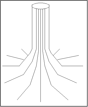
It seems to me that in an environment with large near-surface shear, there is an abundance of horizontal vortex lines in such an environment right near the surface, likely including some local concentrations. As a vortex approaches the boundary layer, it's clear that its vortex lines must turn nearly horizontal and diverge at the base of the intense vortex.
It seems to me that when such a vortex descends far enough to approach a surface boundary layer rich in horizontal vorticity, it might begin to "entrain" those horizontal vortex lines, with the purely horizontal vortex lines of the environmental flow re-connecting to those approaching from aloft. This might well be related to the relatively disorganized first stages of tornadogenesis, with occasional vortices forming in a multi-vortex mode before quickly dissipating. As the process goes on, and the vortex aloft continues to "entrain" the horizontal vorticity of the boundary layer, it organizes eventually into a more stable single vortex all the way down to the surface (still dominated by radially inflowing vortex lines at the vortex base, which is now very near the surface). I've seen tornado evolution along such lines several times: the famous Pampa tornado of 08 June 1995 is a prime example. The Throckmorton tornado of 07 April 2002 formed in a similar fashion, as did the Dougherty tornado of 05 June 1995, the Almena tornado of 03 June 1999, and several others I can recall. It also might help explain the horizontal vortices that are occasionally seen wrapping into and around a primary tornado. In effect, these could be seen as locally concentrated bundles of vortex lines that become caught up in the vortex aloft as it approaches the surface. It is the concentration of vortex lines into tight bundles that produces an intense vortex, be it horizontal, vertical, or wrapped around the main vortex in a spiral.
If this is a significant factor in tornadogenesis, then it would at least begin to "explain" the apparent dependence on low-level shear. Environments with weak low-level shear could support intense vortices near the surface, but might have trouble "connecting" right down to the surface.
I think this also relates to the post-VORTEX I findings suggesting the importance that the near-surface boundary layer static stability should not be too large. It would be tough to draw up those near-surface vortex lines if the static stability of the near-surface air was very high. It has been observed with the mobile Doppler radars that intense, tornado-like vortices can get to within a few hundred meters of the surface but then are unable to intensify right down near the surface. This could be related to the stability of the air mass near the surface, but perhaps is also influenced by just how much horizontal vorticity there is available close to the ground.
Recently, I've taken note that the rope-out phase of a tornado is associated with a noticeable change in the character of the debris cloud near the surface. In a developing or mature tornado, the debris cloud has the appearance of an upside-down umbrella:
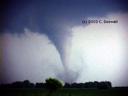
This is apparently the result of strong radial inflow without much vorticity right near the surface. As the air ascends rapidly, the vorticity increases dramatically with height, resulting in a tendency to centrifuge debris outward. The combination of weak rotation right near the surface with a marked increase in vorticity with height above that gives the debris cloud that characteristic shape.
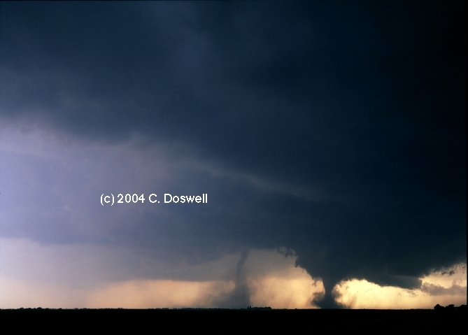
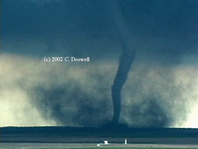
However, when the motion near the vortex changes from predominantly upward to predominantly downward, the vortex doesn't simply stop rotating immediately. It has rotational inertia that permits it to continue. The change to predominantly descending air around the vortex does cause a marked change in the debris cloud - it begins to diverge near the surface and so commences to spread outward right at the surface. The debris aloft often can be seen descending relatively vigorously at this point, as the debris cloud spreads outward and the tornado ropes out.
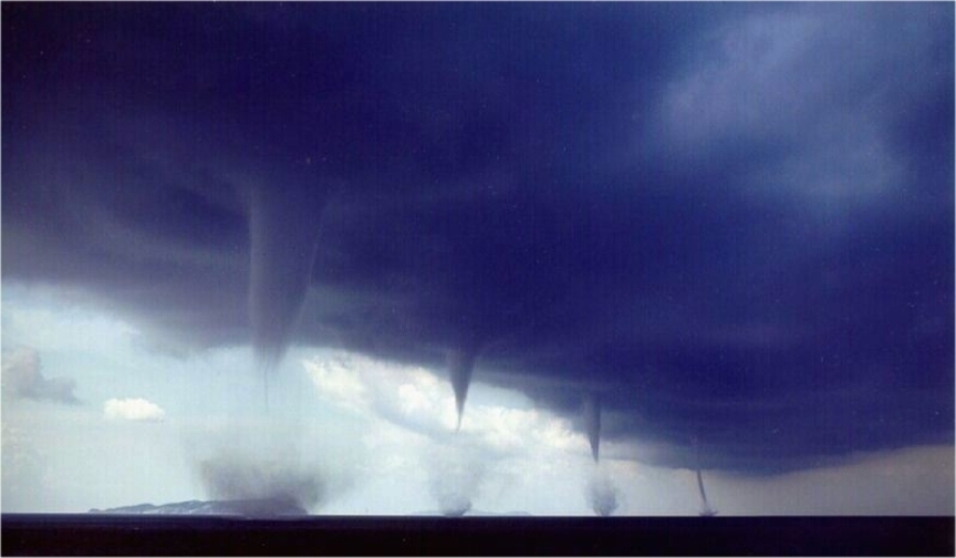
Recently, I watched a program about whirlpools in the ocean. These dramatic extended columnar vortices in the water form in special circumstances - often where tides create a "jet" of fast moving water that is initially separated from slow-moving water by a more or less vertical zone of strong horizontal shear. Typically, the whirlpools on either side of the jet rotate in opposite directions, of course. In such cases, the whirlpools form lines of intense vortices, not unlike some nonmesocyclonic tornado cases:
Abstracting from this, the whirlpools form along a more or less vertical sheet of intense vorticity that breaks down (as theory says it should) by rolling up into vortices. What is happening along the interface between updraft and downdraft as the RFD intrudes into the mesocyclone could well be seen as a more or less vertical sheet of cyclonic vorticity. In the atmosphere, unlike in the ocean, vortices that form along such a sheet of vorticity could be strongly stretched in the vertical when they come within the updraft. These notions are not all that different from some of those arising out of the VORTEX work by Erik Rasmussen and his collaborators (see the link in Section #1, above). It seems the RFD is indeed playing an important role in tornadogenesis, though it's likely to be very different from what Les Lemon and I thought in 1979 (Lemon and Doswell 1979) - I'd like to think that lots of progress has been achieved since we wrote that paper.
Although nonmesocyclonic tornadoes would not be associated with an RFD intrusion into a mesocyclone, they might well be forming along a more or less vertical sheet of vorticity caused by airstreams moving with considerable difference in horizontal velocity (i.e., strong horizontal shear) on either side of a boundary. This boundary could be present even before the convection (as in the well-known Denver Convergence-Vorticity Zone) or it could be a product of the convection itself - perhaps serving to help understand the Quasi-Linear Convective System (QLCS) tornado events. Certainly, the occurrence of lines of vortices in this fashion, along a quasi-vertical vortex sheet, in the "spout" situations (land or water) would be quite comparable to the whirlpools. The preference for cyclonic vortices in the atmosphere could be explained by the dominance of cyclonic vorticity along such boundaries, even on the storm-scale. The hard part about tornadogenesis, it seems to me, is to explain the relative infrequency of such vortices. Perhaps that magnitude of the shear along the vortex sheet is unusual. The presence (or absence) of strong low-level vertical shear (see above) might be relevant in this context, at least for some QLCS cases.
For mesocyclonic tornadoes along the inner flank of the RFD, the fact that the typical evolution only has one major vortex might be at least partially explained by the merger of smaller, weaker vortices into one stable, large tornado vortex. (see item #1) The post-VORTEX I thoughts of Rasmussen and his collaborators have considered the vortex lines associated with the RFD and this is a promising line of research, in my opinion. The RFD "boundary" includes a jet-like morphology associated with the downdraft aloft - with predominantly horizontal vorticity surrounding the downdraft - as well as a quasi-vertical aspect and another jet-like intrusion, this time horizontal, near the surface as it begins to cut into the mesocyclone, creating the clear slot. The evolution and morphology of vortex lines in this situation is not easy to visualize. A tangled web, indeed.
At any rate, the notion that tornadoes of all sorts, including those clearly not associated with mesocyclones, might form along a sheet of vertical vorticity along an intruding "jet" of fast-flowing air is at least an interesting thought. The idea of the rolling up of vortices along such a sheet is not new to tornadogenesis theories but it is particularly interesting by analogy with whirlpools in the ocean. A unified understanding of both mesocyclonic and nonmesocyclonic tornadoes must eventually be found.
I find it somewhat interesting to note that both supercells and bow echoes have an intruding "jet"-like flow into the storm from the rear. In supercells, it's the RFD (see above), whereas in bow echoes, it's the so-called rear inflow jet (RIJ). The famous bow echo sequence developed by Ted Fujita:
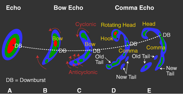
This figure is from the BAMEX Web Site. It shows the evolution of the echo, but does not directly indicate the RIJ. the axis of which is along the dashed line - that represents the track of the "downburst" (DB). The bow shape is derived from the fact that the central axis of the RIJ is thrusting the echo forward most rapidly, forming the bowed-out shape.
On the left side (facing in the direction of the flow) of the RIJ, the horizontal wind shear produces counterclockwise (cyclonic) vertical vorticity, whereas on the right side we find clockwise (anticyclonic) vertical vorticity. Tornadoes in association with bow echoes tend to occur most frequently on the cyclonic shear side of the RIJ axis. It isn't hard to imagine the development of new updrafts along the leading edge of the storm rapidly amplifying local maxima in the existing cyclonic vertical vorticity to the left of the RIJ into tornadic values. The occasional tornado that might occur on the opposite side of the RIJ axis presumably would most likely be anticyclonic. In a sense, this is analogous to the occasional anticylonic tornado that occurs on the right side of the RFD's bowed-out gust front, but is on a larger scale with the typical bow echo than with the typical isolated supercell.
It's also of some curiosity to consider the "rotating head" of the bow echo. If this is a region of active updraft, in effect, the cyclonic "bookend" vortex would be a sort of supercell. However, its origin would be quite different from that of an isolated supercell (which derives its mesocyclonic rotation from tilting of deep layer environmental horizontal vorticity (owing to vertical shear of the horizontal wind) into the vertical. In a bow echo, the vertical vorticity is derived from tilting of the horizontal vorticity produced by the rapidly-advancing cold pool, with the cyclonic bookend vortex being favored because of the Coriolis effect (see Weisman and Davis 1998). Fujita (and others) have noted that tornadoes tend to occur at times with the rotating head, as well as along the gust front on the cyclonic shear side of the RIJ. If the rotating head is viewed as a "supercell" structure - i.e., including a deep. persistent mesocyclone (a view not universally accepted!), then the tornadoes that occur with it would be "mesocyclonic" tornadoes, whereas those along the leading edge of the bow echo between the rotating head and the axis of the RIJ would be "non-mesocyclonic" tornadoes.
Similar to the problem of tornadogenesis for mesocyclonic tornadoes produced by isolated supercells, a serious issue is why most bow echoes (and supercells) do not produce tornadoes. No doubt some sort of balance is required and again, it might be related to the amount of low-level shear (see above). My analogy is that a bow echo is in some ways a fair analog on a larger scale to a supercell - note that the analogy of supercells with extratropical cyclones has already been made (see Doswell 1984). Kinematics knows no scale but the dynamics does. Analogies can be a weak form of argument, but perhaps offer some hints.
I find the analogy between the RIJ and the RFD to be an interesting notion that might represent something worth considering in a comprehensive look at tornadogenesis from the point of view of both mesocyclonic and non-mesocyclonic tornadoes.
It is already well established that tornadoes can form in environments ranging from low-CAPE / high-shear to high-CAPE / low-shear. What has been intriguing is that the plot of the values of CAPE and shear for significant tornadoes (see, e.g., Davies, Johns, and Leftwich 1993) tend to fall on a CAPE-shear diagram within bounding curves - hyperbolas. [Note: the idea of exploring the CAPE-shear product came from a recent presentation by Mr. Dietwalt Fuchs, who was considering this very product during a workshop on tornadoes sponsored by the German Weather Service (DWD) in March of 2005.] If we look at the product of CAPE and shear, this has units of energy per unit mass per unit time, which is related to generation and dissipation of energy, and for any given value of the CAPE-shear product, this is a hyperbola:
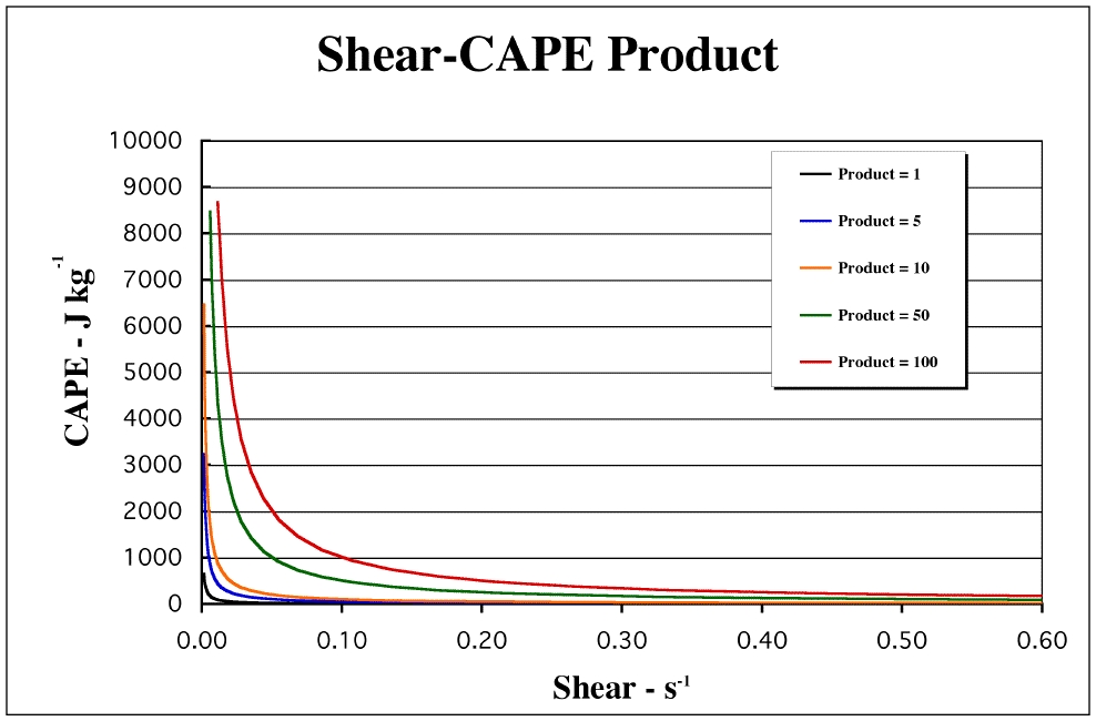
Plotted on a log-log graph, the CAPE-shear product becomes a straight line (not shown - check it out if you don't want to take my word for this). Note that the product curves are hyperbolas whichever way you choose the ordinate and abscissa.
As shown by Johns, Davies, and Leftwich (1993), it seems that significant tornadoes do not occur under conditions of both extreme CAPE and extreme shear - the absence of observed points within the upper right portion of a CAPE-shear diagram suggests that either (a) this part of the diagram represents an environment that happens only very rarely, or (b) the product of CAPE and shear is roughly constant. The data from Johns, Davies, and Leftwich (1993) suggest bounding values of the CAPE-shear product for their cases of about 1 and 15 J kg-1 s-1, as indicated in the figure below:
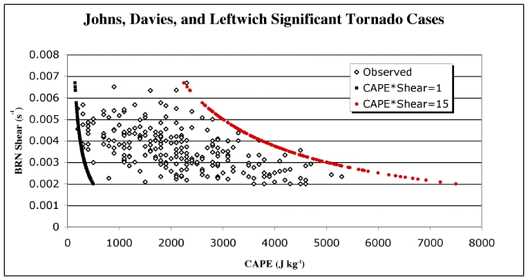
The figure strongly suggests that a minimum BRN shear value is about 2 x 10⁻³ s-1 (2 m s-1 km-1). There also seems to be an upper bound to the shear at about 6.5 x 10⁻³ s-1 (6.5 m s-1 km-1). It might be that too much shear is indeed detrimental to producing tornadic supercells. The lower shear threshold is probably not applicable to nonmesocyclonic tornadoes, which may be predominantly weak tornadoes (F0-F1) -- the jury is still out there -- which can arise in very weakly-sheared (in the vertical) environments. There doesn't appear to be a CAPE minimum value -- except that there must be some CAPE, however small that might be. See Monteverdi et al. (2003) for more discussion of the value of CAPE as a diagnostic or prognostic variable for tornadoes, or, more properly, the absence of any such value.
More work along these lines is underway. I note that the deep layer shear that the BRN shear represents is probably more relevant to forecasting supercells than tornadoes. Therefore this diagram has some inherent limitations. Nevertheless, the apparent coincidence of "bounding" curves with CAPE-Shear product hyperbolas is striking. At this point, I have no clear understanding of what the significance of this range of values might be, but it seems to be a hint at some underlying order regarding the environments in which tornadoes are likely. It could be hinting at the required energy dissipation rate. Perhaps supercells and tornadoes are required only when intense energy dissipation is necessary - when the energy dissipation of ordinary convective processes is insufficient. If so, this suggests that the energy generation rate is relatively far in excess of the capability of ordinary convective processes to dissipate that energy. So the key to understanding supercells and tornadoes would be to understand the rapid energy generation that such events are presumably dissipating. Stay tuned as more will likely be forthcoming ... [09 Aug 2008 - indeed it has - see here]
Doswell, C.A. III, 1984: A kinematic analysis of frontogenesis associated with a nondivergent vortex. J. Atmos. Sci., 41, 1242-1248.
Johns, R.H., J.M. Davies, and P.W. Leftwich, 1993: Some wind and instability parameters associated with strong and violent tornadoes. 2. Variations in the combinations of wind and instability parameters. The Tornado: Its Structure, Dynamics, Hazards, and Prediction (Geophys. Monogr. 79) (C. Church, D. Burgess, C. Doswell, and R. Davies-Jones, Eds.), Amer. Geophys. Union, 583-590.
Monteverdi, J.P., C.A. Doswell III and G.S. Lipari (2003): Shear parameter thresholds for forecasting California tornadic thunderstorms. Wea. Forecasting, 18, 357-370.
Trapp, R.J., and R. Davies-Jones, 1997: Tornadogenesis with and without a dynamic pipe effect. J. Atmos. Sci., 54, 113-133.
Weisman, M.L. and C. Davis, 1998: Mechanisms for the generation of mesoscale vortices within quasi-linear convective systems. J. Atmos. Sci., 55, 2603-2622.