Charles A. Doswell III
Last update: 18 July 2016:
What's new: Some minor updates, fixed some busted links.
a. The definitions
For many years, the most widely-accepted definition of a tornado was found in, among other sources, the Glossary of Meteorology (Huschke 1959):
Tornado -- A violently rotating column of air, pendant from a cumulonimbus cloud, and nearly always observable as a "funnel cloud" or tuba.
Curiously, this definition said nothing about that rotating air column being in contact with the surface. However, the next edition of the Glossary (Glickman 2000) corrected this oversight:
Tornado -- 1. A violently rotating column of air, in contact with the ground, either pendant from a cumuliform cloud or underneath a cumuliform cloud, and often (but not always) visible as a funnel cloud.
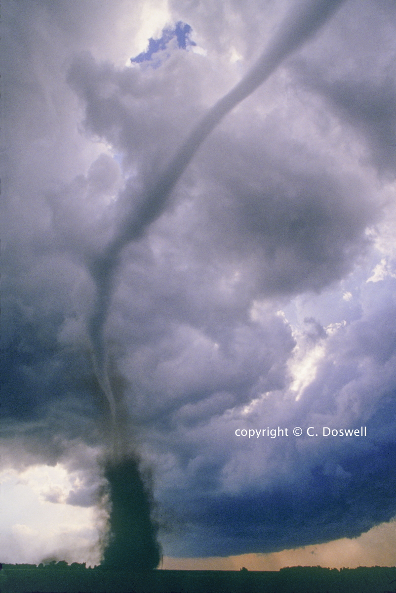
There is no definition of a tornado that has been extensively peer-reviewed.[4] Curiously, the notion of a "vortex" has been troublesome for a long time, because the notion of a vortex is a flow that closes upon itself. But the issue of closure for the flow involves the notion that the wind vectors change if you change to a moving coordinate system. If you find this confusing, please consult my Vorticity Primer, where this concept is described in some detail and also here. The definitions above don't include the word "vortex" perhaps because of this ambiguity associated with the notion of a vortex. But this column of air is by no means necessarily rotating as a solid body. I have no solution to this problem of coming up with a Galilean invariant definition for a vortex. In any case, it's evident when looking at a typical tornado that it represents a closed airflow.
I recently had a stimulating exchange with a reader (Mr. Ben Bosher) about this essay's content. Follow the link to see the discussion. He raises some interesting points about the arbitrary nature of existing definitions, including mine (below).
b. "Touchdown" of a tornado?
Another misconception is the word touchdown in association with tornadoes. I believe "touchdown" is inappropriate to describe the actual process of tornadic winds commencing at the surface. There's nothing coming down, in the sense that a solid tube would fall out of, or descend from, the sky. What actually goes on when a vortex is present in the atmosphere is that the vortex either (a) is already weakly present near the surface, or (b) wraps around itself, like a smoke ring. Again, if you find this confusing, please see my Vorticity Primer, wherein this topic is elaborated. The laws of Fluid dynamics tell us that (a) and (b) are the only two options. As noted by Trapp and Davies-Jones (1997), the intense part of the vortex can build downward, but this isn't the same as a tornado descending. What's actually happening is that the vortex near the surface increases its intensity (typically contracting at the same time) to tornadic criteria - that is, eventually producing winds capable of tornadic damage. But the vortex itself is almost certainly already "in contact" with the ground prior to this intensification. Note that the vortex cannot reach the ground, because the wind at precisely zero height must equal zero - see my Vorticity Primer - unless the surface is a fluid (as with a waterspout), which would be free to move beneath the moving air. Strictly speaking, "the vortex" should not be equated to "the tornado," since a vortex can be present but with non-damaging windspeeds. Prior to the commencement of damaging winds at the ground, the surface vortex is weak and spread out - as it intensifies, the winds increase and the size of the circulation contracts. The vortex also can intensify upward (as we think happens in the tornadoes that are called "landspouts" - see below).
Now, imagine that a relatively weak vortex is present from somewhere at cloud base and above that, that also extends downward to near the surface. Next, imagine that the intensity of that vortex increases uniformly throughout its depth - the laws of fluid dynamics demand that this be accompanied by a drop in the pressure along the axis of the vortex. A visible funnel cloud is simply an indicator that the pressure has fallen far enough that condensation can occur. The condensation cloud is funnel-shaped because the pressure drop of the vortex is greatest along the vortex axis and decreases outward from that axis. If the pressure drops by some value dp everywhere in that columnar vortex, then where should condensation begin first? Obviously, it would first begin just below the cloud base, where ascending air is already close to its condensation level. Near the cloud base, the pressure drop dp would be enough to create condensation, but not necessarily well below that. As the vortex continues to intensify uniformly along its depth, that condensation surface would drop lower and lower simply because the pressure drop associated with the vortex is increasing, thus allowing condensation at a lower and lower level - eventually reaching the surface. This can explain the apparent lowering of a condensation funnel. Of course, the intensification of a vortex uniformly through its depth is a simplification of what might actually be occurring, but it might be a decent approximation in many real tornadoes.
We don't have high-resolution measurements of the pressure distribution in and near tornadoes, of course, and a tornadic pressure field may have many complexities. However, it's unlikely that clouds from above are descending to create the funnel-shaped cloud - generally, descent dissipates clouds. Of course, it could be that descent in the core of a two-celled vortex might produce a funnel-shaped cloud simply by pulling down cloud matter in a way that evaporation of the cloud droplets is relatively slow along the axis and relatively faster along the margins, resulting in a tapered funnel. Someday, perhaps, we can get some answers ... .
During our chase in 1989, my partner (Al Moller) and I happened to drive right under a strongly rotating towering cumulus. As it passed overhead, our surface winds changed from southeasterly, to easterly, to northeasterly, to northerly, to northwesterly, to westerly, to southwesterly, all in within a minute or two! At no time were the winds more than 10-15 knots. We experienced a surface vortex of near-tornadic size but not of tornadic intensity! [an F-(minus)1 tornado?] Later on, this rotating cloud produced a tornado.
Rather than "touchdown" I would prefer to consider the observed process of the commencement of tornadic winds at the surface to be one of "spin-up" - I hasten to add that "up" in this context does not imply ascent, but rather an increase of spin intensity, producing an associated pressure drop along the axis of the tornado.
c. Reaching the surface
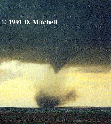
A widespread misconception about tornadoes within the public at large is that unless the condensation cloud associated with that rotating column of air is touching the surface, it's not a tornado. This is manifestly untrue, as most meteorologists and many storm chasers realize fully. Since it's the wind associated with the rotating air column that does the damage, it's the moving air (wind) and not the cloud that constitutes the tornado. Many tornadoes have been observed (Fig. 1 is but one of countless examples) that don't have condensation funnels all the way to the surface, but clearly are in contact with the ground. It's quite possible for the circulation to be more or less completely invisible for at least some portion of the life cycle of the event. In the case of waterspouts (see below), this is frequently the case, but such events also occur in the dusty, dry mid-continental plains (Fig. 2). Chasers may refer to these events with such slang terms as "dust bowls" or "dirt-daubers."
Fig. 1. Example of a tornado where the funnel does not reach the surface, on 15 May 1991, near Laverne, Oklahoma [photo �1991 DeWayne Mitchell, used by permission].
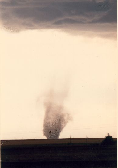
Fig. 2 Example of a tornado with no visible funnel, on 02 July 1987, near Denver, Colorado [photo �1987 Bill Gallus, used by permission].
When the visible funnel does not reach the surface, silly reports of a "funnel cloud accompanied by wind damage" can occur, or such absurdities are reported as "The funnel only reached treetop level" or whatever. We probably will find it difficult ever to convince the public as a whole that a tornado is wind and not the funnel cloud. Hopefully, no self-respecting meteorologist would do anything to perpetuate such misconceptions. Also, storm chasers who believe this could get into a lot of trouble, quickly! By the way, "tornado on the ground" is redundant, since to be a tornado, the damaging winds must be present at the surface at that time.
Many strong-to-violent tornadoes include a phase where the tornado appears as a truncated cone funnel (not reaching the surface) with occasional rope-like multiple vortices beneath it (e.g., the Xenia, Ohio tornado of 03 April 1974 or the Binger, Oklahoma tornado of 22 May 1981, Fig. 3). Lay persons might have considerable difficulty recognizing this for what it is, since it doesn't look like a "funnel-shaped cloud." Such an appearance, however, does not imply that the tornado is of strong-to-violent intensity - a tornado's appearance is not a reliable indicator of its intensity, chaser lore notwithstanding.

Fig. 3. Binger, Oklahoma tornado of 22 May 1981, showing a truncated cone funnel with multiple vortices. [NSSL photo by Erik Rasmussen],
Among chasers, it's a common assumption that if a funnel cloud extends halfway or more to the ground from cloud base, there's almost certainly a tornadic circulation at the surface. This may or may not be true in any specific instance - it probably is more often right than wrong. For official purposes, however, such a "storm chaser's rule" is not a legitimate assumption. By definition, the existence of a damaging circulation at the surface must be confirmed before the event can properly be called a tornado. If such a confirmation cannot be made, the event must be considered to be a "possible" tornado.
Thus, vortices can be present at the surface even without any visible funnel cloud. If a condensation funnel is present that doesn't extend from cloud base to the surface, some sort of "circulation" [10] is virtually certain to be present, but it may not be sufficiently intense to raise visible debris. In the absence of debris, it is hard to know if the situation has become tornadic or not. I'll return to this later.
NOTE added 18 July 2016
(thanks to some email discussions with a reader - George
Tsavdaris): A "no slip boundary condition" means that the wind at
the surface must be exactly zero. Therefore, strictly speaking,
the intense airflow of a tornado never extends all the way to the surface. However, high-speed winds can extend to quite near
the surface as can be observed in real tornados, and the tangential
(rotating) winds of the tornado become quite small while the converging
radial airflow dominates.
d. What's a "funnel cloud"?
Traditionally, the notion of a "funnel cloud" has been associated with a possibly tornadic vortex that is not in "contact with the surface" (see above added note - the airflow of the vortex goes to zero right at the surface!). This poses something of a problem, as discussed above. If a funnel cloud that remains "aloft" is produced by an intense vortex, then what's the nature of the vortex lines that define that vortex? Do they form closed loops (vortex rings) or do they diverge above and below the relatively intense vortex aloft? Observations as yet provide little or no information about these "funnel clouds" not clearly associated with tornadoes. Further, a funnel cloud is often associated with tornadoes, whether or not the cloud extends all the way to the ground (e.g., Fig. 1). If the tornado is indeed the wind, as noted above, and not the cloud, then the cloud's vertical extent is irrelevant to whether or not it's a tornado, with a potentially damaging vortex flow at the surface. So the traditional use of the term "funnel cloud" - synonymous with an "intense vortex not yet in contact with the ground" - is simply not appropriate. There is as yet no useful term for an intense vortex that's not in contact with the ground - a funnel cloud can be tornadic or non-tornadic! Some funnel clouds become tornadic (e.g., Fig. 1). and others don't. Some tornadoes have funnel clouds but others don't (e.g., Fig. 2).
Having mentioned waterspouts, this raises another topic. There's a special name for a tornado moving over the water: a waterspout. Why do we not have special names for tornadoes moving over sand (sandspout?), or asphalt (tarmacnado?), or mobile homes (manufacturnado?), or eucalyptus trees (gumspout?)? Is it a waterspout if the water is fresh water rather than sea water? Does it become a waterspout if it moves over a lake? What about a pond? How about encountering a swimming pool or perhaps a puddle? How big does a body of water have to be to create a waterspout from a tornado? What about when crossing a river? A creek? A dry streambed? Would this last example be a "dry waterspout"? I'm engaging deliberately in reductio ad adsurdum here because I don't believe there is any scientific distinction of consequence between a waterspout and a tornado!
In the new Glossary (Glickman 2000), in fact, the definition of a waterspout is now:
Waterspout -- 1. In general, a tornado over a body of water. 2. In its most common form, a nonsupercell tornado over water.
For years, people believed that waterspouts were a distinctly different phenomenon, uniquely associated with tropical and subtropical convection that might not even qualify as cumulonimbus clouds. Of course, some "authorities" knew of the annoying problem of supercell tornadoes over water - recognition of this produced the abominable term: "tornadic waterspout." Of late, it's been observed that phenomena quite comparable to waterspouts arise over the land, leading to another dubious term (that I've used!): "landspout" (by analogy, a "waterspoutic tornado"?). In my opinion, all these terms refer to the same phenomenon: an intense vortex associated with deep moist convection. Thus, I dispute the standard definition for its exclusion of convective vortices that happen with clouds not meeting the criteria to be cumulonimbi (e.g., those without glaciation at the cloud top).
I'm proposing the following revised definition:
Tornado -- A vortex extending upward from very near the surface at least as far as cloud base (with that cloud base associated with deep moist convection), that is intense enough at the surface to do damage.
This is without regard to
My broadened definition is designed to ignore what I consider to be incidental aspects of the situation. I believe that the physical process giving rise to an intense vortex is not associated with any of these coincidental issues and so the labeling of the real vortices that occur should not depend on them. It also excludes any phenomena not associated with deep moist convection, such as dust devils or "mountainadoes," and avoids making artificial and scientifically unjustified distinctions between "spouts" and tornadoes.[5]
I hasten to add that I do not believe that the physical processes giving rise to tornadoes are all the same. It appears that tornadoes can arise in several different ways, and perhaps different process can be associated with the same tornado at different times in its life cycle. Moreover, not all tornadoes associated with a given moist convective cloud arise via the same processes (see Doswell and Burgess 1993). Some of the relatively intense vortices associated with a convective storm probably should not be considered tornadoes; e.g., circulations not capable of doing damage near the surface, and true gustnadoes (not extending to cloud base - see below), assuming we can identify them as such. There's a fair amount of anecdotal evidence for non-tornadic intense vortices in association with convection (see Moller et al. 1974; Cooley 1978; Doswell 1985; Bluestein 1988; Doswell and Burgess 1993; Bluestein 1994), but not much hard information about the processes giving birth to these vortices.
At present, we're more or less content to classify tornadoes according to whether or not they occur with supercells. (I prefer to make the distinction as mesocyclonic vs. nonmesocyclonic tornadoes.) In the future, it may become scientifically useful to sub-classify tornadoes even further, as we learn more about how real events occur (as opposed to, say, events in our computer simulations!). If we must classify, then it seems to me that we should do so on the basis of physical processes and not be concerned with superficial aspects of the events. We are far enough along in our understanding of tornadoes that we ought to be able to move at levels deeper than the surface now.
Now, I wish to move into much more speculative and uncharted territory. For a tornado such as the famous Union City, Oklahoma tornado of 24 May 1973 (hereinafter referred to as "UC"), the life cycle of the event can be reasonably clear and understandable. The early stages with a rotating wall cloud move to the development of a funnel cloud, then damage at the surface begins, followed by the descent of the funnel cloud to the ground. The width of the funnel increases to some maximum, and then begins to shrink, finally reaching a rope-like dissipation. The documentation for the UC event is extensive (see Brown 1976) and it might even be considered prototypical for many purposes. There's relatively little ambiguity in such events - there obviously was only the one tornadic vortex and its visual evolution can be inferred without much error from looking afterward at the evidence along the path. The UC damage path, surveyed extensively immediately after the storm, matches the visual images quite nicely. The visible funnel was more or less continuous until dissipation. The damage path coincides quite nicely with the visible vortex evolution. During dissipation, the visible funnel disappeared, but a clear debris cloud was still present for a few seconds longer at the surface.
All tornadoes are not this simple, however. The reality of tornadic events comprises a range of visible aspects that at times can be confusing and defies simple classification schemes. Multiple vortices introduce some complications. The UC event did not exhibit any obvious multi-vortex phase, but many tornadoes do. To some extent, the multi-vortex phenomenon is relatively well understood; the formal scientific literature on the subject (e.g., Snow 1978; Rotunno 1982; Gall 1985; Lewellen 1993) is fairly extensive. Recently, the occurrence of "satellite" tornadoes has been documented - apparently separate tornadoes that form near an existing tornado and rotate around that preexisting tornado. Whereas vortices like the UC event are "stable" in the sense that their visual aspect changes only slowly with time, other vortices are not so stable. The classic video from a helicopter in Minneapolis on 18 July 1986 illustrates the erratic, rapidly-changing visual structure of tornadoes having persistent multi-vortex behavior. Looked at from the perspective of a post-storm damage survey, however, the damage path in such a case might give a much more continuous "picture" of the event. Whereas the visual images are changing rapidly, the damaging winds at the surface can be more or less continuous, so if we didn't have the video, our damage survey might conclude with little doubt that a single tornado was involved, even though eyewitness accounts might well seem to contradict that rather vigorously. As scientists, we might smugly dismiss those eyewitness accounts with the observation that it probably was a multi-vortex event. For the Minneapolis event, all is well with such a dismissal - when visual evidence is present, perhaps we can afford to be smug. In the absence of visual documentation, I'm rather less inclined to heap scorn on eyewitness accounts of seemingly odd tornado behavior. I wasn't there, so I can't be certain what the eyewitnesses saw! [1]
After the 08 June 1974 tornado outbreak in Oklahoma and Kansas, I saw some 8 mm film (this was prior to the video age!) footage of a remarkable tornadic evolution; I believe it was a tornado near Luther, OK. I've since been unable to relocate that footage, unfortunately. My memory of the film is that a quite distinct tornado (somewhat reminiscent of the UC funnel in shape, but with a lower cloud base) was moving along seemingly in a relatively stable fashion, when it seemed to dissipate suddenly and another similar funnel appeared rapidly right next to where the original funnel had been, all within about a second or two. The rapidity with which this remarkable transformation occurred was amazing to me. It seems rather obvious to me now that my memory (and those of others who saw this footage) of this visual record is the only available evidence that such an event occurred, since that film appears to be gone or at least unlocatable. The proximity of the two funnels virtually guaranteed that the damage path, as surveyed, would be viewed as continuous. Thus, if there were some slight offset in the damage path associated with the dissipation of one funnel and the development of the next, it almost certainly would not be evident to those doing a damage survey. To my knowledge, the tornado is classified as a single event. Perhaps this is a proper classification; perhaps this was simply a brief visual manifestation of a transient episode in the life of a single tornado. I raise the point simply because of the questions raised by that sudden transition.
Another, somewhat similar, episode has been documented by Davies et al. (1994) for the Hesston, Kansas tornado of 13 March 1990. In the Hesston storm, the visible funnel seemed to dissipate rapidly and re-form near the axis where it had been earlier but with a substantially smaller diameter, all within a brief time span. The question was asked, but not answered: Was this all a single tornado or could it be viewed as the dissipation of one tornado, followed by the nearly immediate development of another? Again, apparent continuity of the damage seems to leave this particular instance reasonably well-defined as a single event. Is it possible to conceive of such an event with a somewhat longer time span between the dissipation of one funnel and the development of another? I certainly have no trouble imagining something of that sort happening, such that a superficial examination of the damage path still might not detect such a gap. Not all damage surveys involve a thorough analysis of the path from start to end, both from the ground and from the air. Moreover, there might be several ways in which the illusion of a continuous damage track would appear even with a reasonably thorough survey. How big a gap in the path is enough to start considering the events to be separate? This brings me to the following discussion:
In my experience, tornadoes do not skip, like rocks thrown nearly parallel to a water surface. Rather, they weaken or intensify and thereby create gaps in the damage, but their continuity as a vortex is relatively high. I've not heard a lot of storm chasers discussing how the tornadoes they observe "bounce" and "skip" across country. Gaps in the damage path can arise because (a) there's nothing to damage, or (b) the circulation has weakened to the extent that no evidence of the tornado's passage is left. Should we consider the latter to signify that the tornado "skipped" or "lifted" during an otherwise continuous track? Even more radically, would we say the cessation in damage constitutes a cessation of the tornado? In many such cases, it's clear from film or video that a visible funnel and even a dust and debris whirl (albeit perhaps only small debris) is continuous even though "damage" is not occurring. In such a case, the damage path would give erroneous input to the classification of the event, often leading to the notion of "skipping" as a means of avoiding having each gap in an otherwise linear path represent a gap between individual tornadoes.
Therefore, I proposed the following, slightly modified definition of a tornado:
Tornado -- A vortex extending upward from very near the surface at least as far as cloud base (with that cloud base associated with deep moist convection), that is intense enough at the surface to do damage at one or more points along its path.
In some of these cases, it certainly can be argued that these are transient, superficial fluctuations in what might well be interpreted properly as a single event. A continuous, more or less linear damage path would be a compelling argument in favor of such an interpretation. However, the existence of multiple vortices and satellite tornadoes, now accepted variants of tornadic behavior, raises some troubling issues about the relationship between a tornado and its damage path - again, especially in the absence of a visual record of the event.
Furthermore, I've specifically avoided defining the windspeed at which "damage" begins (or ends!). The current windspeeds provided in the Fujita scale [see here (item #B.11) and here] indicate that F0 damage begins at 40 mph. That's not even a wind strong enough to qualify for a "severe" thunderstorm by operational standards (58 mph)! However, a 40 mph wind certainly would raise surface dust in, for example, many parts of West Texas! An observer must see "debris" at the surface if an event is to be considered a tornado, but this requirement is pretty nebulous. The ability to raise debris is, in a very real sense, dependent on the underlying surface and the conditions preceding the event. It's harder to raise dust on a muddy field than a dry one, or on a grassy field compared to bare soil. We're unlikely soon to be able to obtain windspeed measurements routinely associated with tornadic surface circulations in real time (i.e., as an observer watches the event), so it seems pointless to establish windspeed criteria in the definition, whatever might have motivated Prof. Fujita to do so. The only value it might have would be in the abstract, or for the unforeseen future, where it might someday be possible to get detailed windspeed measurements routinely. If I were pressed to provide a threshold, I'd say that the minimum tornadic windspeed should be 58 mph (50 kts or about 25 m s-1), which is the current threshold used for "straightline" winds in thunderstorms.
For clearly damaging tornadoes with clearly visible condensation funnels, etc., there's little ambiguity. It's only on the margins of the definition that we have problems (although that seems to be a common problem with any definition, as this essay, overall, is suggesting). The ambiguity of what winds are capable of producing "damage" clearly feeds into the problem of "skipping" tornadoes, of course.
Atmospheric vortices form a spectrum, in my opinion, with no clear kinematic boundaries between events. That is, atmospheric flow can be organized into vortices of essentially any size and aspect ratio. The fact that there are preferred sizes often reflects the existence of the dominance of some physical instability that has a characteristic scale length (e.g., baroclinic instability in the case of extratropical cyclones). Thus, vortices can be classified according to the physical processes that give them birth, but there's no compelling reason for classifying vortices solely on the basis of their size. Hence, the boundaries among events have an obvious tendency to be quite "fuzzy." We think we know, for instance, the characteristic scale size of an extratropical cyclone. We also know that cyclonic storms exist which we consider to be "distinct" in some way (typically size is a factor in making such distinctions) from extratropical cyclones - for example, polar lows or tropical cyclones. Nevertheless, there are times when polar lows or even tropical cyclones seem to have a decidedly baroclinic aspect and one can get into intense arguments about where any particular event fits in a taxonomy of cyclones. It seems that even on synoptic scales, there's room for debate over classifications.
If we put a particular event into a particular bin, we tend to apply a set of default assumptions about the character of such an event. This can be the source for considerable confusion at times, as I have tried to indicate in a comment about a particular classification scheme (Doswell 1991). Classification doesn't seem to be a very important aspect of science to some, but it affects the way we view the real world. In effect, putting an event into a "bin" seems to imply all sorts of things about that event which may not be valid for the particular instance. The atmosphere produces a wide range of vortices in association with convection (including dust devils with dry convection!) - if we have trouble with classification of such vortices, it's important to keep in mind that it's our problem, not the atmosphere's.
Having put up with this preamble, indulge me for a bit more. I'm going to describe a pot pourri of events that (a) I've witnessed directly in storm chasing, or (b) I've had described to me (perhaps with images) by fellow storm chasers, (c) I've seen in film and video of events, or (d) are reasonable extrapolations of things unobserved but which could be observed and yet not be documented.
a. Mesocyclones[2]. A characteristic of mesocyclones is that they represent a perturbation flow that's roughly the same size as the updraft region of a cumulonimbus. Although cumulonimbus clouds don't cover a huge range of sizes, neither are they all the same size. Thus, mesocyclones almost necessarily have a range of sizes, mostly on the order of a few km in diameter; as opposed to a few tens of km in diameter or a few hundred m in diameter. Moreover, mesocyclones have a range of intensities, with the intensity usually measured in terms of shear or vorticity. Arguably, another measure of intensity could be the maximum windspeed anywhere within the mesocyclonic circulation (the boundaries of which might be a bit tough to define, if pressed). Some mesocyclones, perhaps even some on the lower end of the size range, could easily be associated with windspeed maxima in a range where damage would result if they interact with the surface. Such an event, if it occurs in the real world, meets the definition of a tornado I quoted earlier! That is, it's a violently rotating column of air in association with a deep convective cloud and is in contact with the surface of the earth. Such events could even have cloud material right down to the surface in the right environment, manifesting themselves as a wide tornado. I can see no hard and fast boundary between large tornadoes and small mesocyclones.
b. Multiple-vortex mesocyclones. Gene Moore (a reasonably well-known and highly respected storm chaser) once showed me photographs of an amazing event he witnessed in the Texas Panhandle. It involved a large. clearly rotating wall cloud, apparently several km in diameter. From time to time, a funnel cloud would form, producing what appeared to be a slender, ropy tornado around the periphery of this wall cloud. The funnel cloud typically would extend to the surface briefly and then dissipate, to be followed a few minutes thereafter by another such event elsewhere on the wall cloud's periphery. Apparently, this went on for some time. Is each such event an individual tornado, or are they simply vortices embedded within a single large multi-vortex tornado with intensity fluctuations? If one were to look at the damage carefully, it's not entirely clear that a single damage path would be involved. The damage might appear to be quite chaotic, given the vagaries of the associated events and the likelihood of a damaging event interacting with something (trees and structures are pretty sparse in the Texas panhandle) to mark the event. Short streaks of damage might have various orientations and could be oriented in diverse directions. Without visual documentation, it might be possible to do a damage survey and conclude that what had happened was a series of microbursts or a number of brief tornadoes. Note that a rather well-respected survey team (which will remain anonymous) overflew the track of a documented tornado on 10 April 1979 near Seymour, Texas and concluded it was a downburst, so I have reason to believe that a damage survey - even when done by experienced "experts" - is not necessarily definitive!
Given a mesocyclone, who can say that they're all dynamically stable, slowly-evolving phenomena? A mesocyclone might well manifest the same multi-vortex complexity that virtually all vortices exhibit, resulting in a miniature tornado "outbreak" of a sort (as described by Snow and Agee 1975). Suppose there was a fairly regular production of such events associated with a moving storm, at intervals in space and time. Such a case would appear as a tornado "family" associated with a traveling supercell (the Fargo events of 20 June 1957 are the prototypical example, as documented by Fujita 1960). For such a case we've universally chosen to accept them as separate tornadoes, but it might be argued that they really are simply manifestations of a single event: a long-lived mesocyclone with episodic intensifications of that continuing vortex. How do we draw a line here? Is it so hard to imagine situations where classification might prove troublesome? What about a small, intense mesocyclone in a high-humidity environment? Such an event might have a nearly continuous lowering and spotty damage, with subvortices that could be considered tornadoes or tornado cyclones. How large (small) and intense (weak) can a tornado (tornado cyclone, mesocyclone) be? Where do you propose to put the dividing lines between tornado-tornado cyclone-mesocyclone? As noted, the atmosphere just produces vortices and neither knows or cares about how we choose to interpret the events.
c. Large, multiple-vortex events. I've seen video (in Tornado Video Classics III) of another amazing event in the Texas Panhandle, near Lazbuddie on 10 May 1991. This event apparently involved a relatively large tornado (on the order of a UC funnel) at the center of a ring of smaller tornadic vortices. The central funnel was more persistent than the surrounding ones, with several funnel clouds in contact with the surface simultaneously from time to time. Is each funnel in such an event a single tornado, or is the whole collection simply a manifestation of a single tornadic event, with multiple vortices? Is it one tornado within a multivortex mesocyclone? Or is it a primary tornado with multiple, simultaneous satellite vortices? How does one classify such a mess? Presumably, these are rare events, but exactly how many tornadoes should be recorded for such events?
d. Tornado cyclones. During the Pampa, Texas tornado I was privileged to witness on 08 June 1995, a fascinating evolution occurred. The tornado I will call the "first" tornado began as a ragged, rotating lowering that produced several brief episodes of dust whirls and small debris at the surface, apparently out in open country southeast of Pampa. During that same time, low-level, multiple-vortex funnels appeared and then disappeared within a few seconds on several occasions. Following this, the tornado seemed to become very disorganized, with a new area of rotation developing as a clear slot wrapped around a truncated, cone-shaped funnel near where the original rotation became disorganized. This second area evolved into a very "stable" tornado. As this was happening, another funnel was developing to the northeast of the event we were watching, which I will call the "third" tornado. The interaction of these two cyclones was odd in that the second tornado (southwest of the developing third tornado the whole time) initially moved westward, then northward, and finally northeastward, whereas the third tornado (developing rapidly as the second one was dissipating) apparently moved mainly northward. Was the first series of brief debris whirls and occasional multiple-vortex funnels (without a complete connection to cloud base) a separate event from the event that finally moved through western Pampa? Or was it all a single tornado? Were there two mesocyclones or were we seeing separate "tornado cyclones" within a single mesocyclone? Perhaps the data available will permit answers - but most likely not. In most cases, of course, high-resolution data and videotapes of the event would not be available. These details are simply lost for most events. See here for more discussion of similar observations and what they might imply.
e. Other weird things. It is plausible to believe that gustnadoes can develop into tornadoes (see below); there are at least some indications [e.g., from Erik Rasmussen in some personal communications] that a true dust devil could, as well! Essentially, there are many ways to produce an intense vortex from a preexisting, nontornadic vortex. Since there's a lot we don't know or understand, if we look carefully, we may continue to find examples that don't fit our nice, clean hypotheses.[8]
Perhaps some of you have seen a video of two funnel clouds that are seen at cloud base -. with time, the vortices curl toward each other and seem to "connect" - what's happening is a vortex that wraps around itself, just like a smoke ring. Since air is a fluid, it obeys the laws of fluid dynamics, which include this "law" of vortices (that they form loops ... see my Vorticity Primer). NSSL has a photo showing this phenomenon of a vortex ring (see photo #3 in the NSEA Photo Gallery). These have been given the name "bowtie funnels" by some storm chasers. Since the strong rotation is not in contact with the surface, this can't be a tornado, despite it being an intense vortex associated with a convective cloud.
The events I've been describing above and others, some mentioned in the reviewed literature (Doswell and Burgess 1993, Davies et al. 1994, Forbes and Wakimoto 1983, etc.) and some not, all make me concerned for what we've recorded as tornadoes in the historical record. For example, insofar as that record is concerned, the Tri-State tornado is a single tornado event. As already discussed elsewhere (Doswell and Burgess 1988), there's room for debate about whether or not this actually was a single event. Continuity of the damage path is, as I've suggested, not entirely convincing that a single tornado was involved. Of course, I'm even questioning whether a tornado "family" of the sort that might be involved with the Tri-State event is really more than one event. In other words, I'm not taking a dogmatic position here - I'm willing and eager to consider other views, but what concerns me is that (a) we have the debate, and (b) we reach some consensus about how to record the real events.
The growth of scientific understanding about tornadoes does not mean that clarity of insight follows immediately. As noted, I feel somewhat concerned about our concepts of tornadogenesis. A tornado (as I am fond of saying), irrespective of the details of the definition, is not an object; it is a process. That is, the wind field that we define to be the tornado exists as a result of, and evolves in response to, other processes. Observationally, it seems that vortices of this intensity are produced virtually exclusively in association with deep moist convection. There surely are dust devils (dry convective vortices) that attain damaging proportions but they are uncommon and we know essentially nothing about their distribution. Since the strongest dust devils probably occur in arid regions of extremely sparse population, our ignorance of such events is large.
Within the range of vortices associated with deep moist convection, I suspect that a lot of different processes can produce vortices in convective clouds, very few of which affect the surface. There's some limited mention of such events in the literature (Moller et al. 1974; Cooley 1978; Doswell 1985 [p. 107]; Bluestein 1988; Doswell and Burgess 1993; Bluestein 1994; etc.). For example, Cooley's paper is the only mention of "cold air funnels" in the refereed journals. At times, I've heard of funnels being tagged by NWS operational forecasters as "cold air funnels" in situations quite radically different from the prototype described by Cooley and discussed briefly in Doswell and Burgess (1993). An erroneous classification of such vortices might be prompted by a perceived need to "explain" surprise observations of funnels, but it probably does more harm than good to provide a bad explanation. Unfortunately, science can offer little more than speculation about the origins of these mostly non-tornadic vortices (e.g., Bluestein 1994). It's likely that some small percentage of these minor events (examples shown in Fig. 4 and Fig. 5) could produce damaging winds at the surface, but I have no way of knowing what that percentage might be, nor by what processes such vortices might come to reach damaging intensity at the surface, to say nothing of their origins.
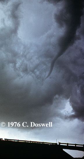
Fig. 4. Example of a non-tornadic vortex seen on the northwest flank of the UC storm on 24 May 1973 [photo �1973 C. Doswell], as discussed in Moller et al. 1974.
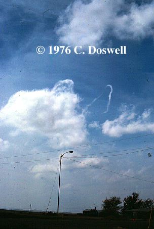
Fig. 5. Example of a non-tornadic vortex associated with a dissipating cumulus cloud on 13 April 1976, near Shamrock, Texas [photo �1976 C. Doswell]. These are sometimes referred to by chasers as "horseshoe" funnels.
Events that we might reasonably call tornadoes appear to be associated with:
As noted in Davies-Jones and Brooks (1993) and discussed in another essay of mine, the issue with a tornado is to get the high vorticity near to the surface. It appears that processes associated with the mesocyclone and low-level boundaries are likely candidates for obtaining tornadic vorticity at the surface. I note that a supercell (in my opinion) need only have a mesocyclonic circulation meeting certain criteria (see Doswell 1996) to qualify as a supercell and that the mesocyclone need not be present at low levels. (Other views exist; see, e.g., Droegemeier et al. 1996.) Low-level mesocyclones are apparently the result of different processes than those that produce mid-level mesocyclones (see Brooks et al. 1994). At this time, it's unclear what percentage of low-level mesocyclones produce tornadoes, but apparently fewer than 50 percent of those storms having mesocyclones at any level produce tornadoes. [Note - added on 26 June 1998: this percentage might be as low as 10 percent!]
In the case of "landspouts," it seems that pre-existing vortices along pre-existing low-level boundaries might "explain" some examples tornadogenesis in non-supercell storms. With those tornadoes that seem to form aloft and descend (the TVS - see Trapp and Davies-Jones 1996), the story may be complex dynamically, and involve an interaction between the updraft and its own rain-cooled outflow. It also could be that real events involve a complex mixture of all three processes [(a)-(c), above] at times. Whatever we find out about these processes in the real world, it almost certainly is going to be the case that there's no single path to a tornado, even when we restrict our attention to those events that are clearly and unambiguously tornadoes (Including landspouts - landspouts are tornadoes, by any reasonable definition of a tornado. Like the waterspout, I'd prefer not having a specific term for this kind of event, since it only seems to create confusion.). Not all significant tornadoes are the same, even though their flow fields might end up looking alike - a vortex after all, has a certain characteristic kinematic structure irrespective of the dynamical processes that produced it.
There's another class of events that has caused a large amount of heartburn: gustnadoes. Observations indicate clearly that relatively weak, short-lived vortices can form along the leading edge of an outflow boundary. The mechanism(s) by which such vortices form? No one really knows but they might be associated with a little-studied process known as "lobe and cleft instability" along density current boundaries. Hence, almost anything I can say about these events is pure speculation. We have no detailed Doppler radar observations of them; we have no numerical simulations of them; we have virtually no validated knowledge. All we have is anecdotal evidence from storm chasing and some analogies with things seen in laboratory simulations (Idso 1975). The visual appearances of true gustnadoes (as opposed to tornadoes along a gust front, which are manifestly different phenomena) indicate they are shallow (perhaps 10-100 m deep) with no apparent connection to any process happening at cloud base or above (Fig. 6). When they arise, which I believe to be frequently, they occur in "swarms" such that there may be several in existence at the same time along the same gust front, forming and dissipating within no more than a few minutes and probably having only relatively weak wind perturbations. Superimposed on a damaging gust front (i.e., a downburst), they might represent local concentrations of damage. Superimposed on a non-damaging gust front, they might be manifest as isolated damage events in an otherwise benign situation. My guess is that typically, they represent only a minor perturbation of essentially no significance, except in rare instances.

Fig. 6. One of several gustnado events near Welch, Texas on 23 May 1982 [photo �1982 by Chuck Doswell].
I have some anecdotal evidence that a gustnado can evolve into a true tornado [Dave Blanchard, personal communication], but such an evolution is almost certainly infrequent. Whereas some true tornadoes might initially resemble a gustnado at the start, I certainly would find it easy to deny gustnadoes (as I've defined them) the status of true tornadoes. Unfortunately, it may be hard to train folks to be able to distinguish them from other vortices occurring in conjunction with deep, moist convection. I certainly have encountered a lot of different notions about gustnadoes, even among meteorologists, much less the lay public. There seems to be a disturbing trend to refer to all tornadoes occurring on a gust front as "gustnadoes" whereas I've tried, apparently without much success, to confine the term to the shallow vortices on gust fronts that seem not to extend as far as cloud base. Moreover, even with 20+ years of chasing behind me, I still am encountering things I haven't seen before. What about the person experiencing something like this for the first time? If that person is confused and has a hard time sorting out what s/he experienced, I think they can be forgiven. But we need not assume that the public is congenitally stupid, either. Some people can report quite accurately what they saw, but they describe it in inappropriate terms (e.g., a tornado with multiple vortices becomes several tornadoes merging into one)
There's a lot we don't know about what happens along seemingly boring, 2-dimensional gust fronts! Perhaps gust fronts are prone to dynamical instabilities on a variety of scales, some of which remain small (gustnadoes), some of which are large and persistent enough ("misoscale" eddies) to become a bona fide tornado. There might be a whole spectrum of vortex structures along gust fronts, many of which do not attain "tornadic" proportions (however we might choose to define a tornado). If that's the case, then it might be quite difficult to anticipate when a gust front would produce damaging vortices, from gustnadoes on up to and including what would unambiguously be called tornadoes. The topic of what might happen along gust fronts was written about by Idso (1974; 1975) in a very speculative vein, but little of substance has been done with the topic.
This topic never seems to go away for long, so I suppose I should say just a little more about cold air funnels. There's not much about them in the literature - the only published paper about them of which I'm aware is that aforementioned one by Cooley (1978) and it offers relatively little insight. Doswell and Burgess (1993) have discussed them, but not in depth, because little of depth could be said. They occur in association with convective clouds (that may have little or no thunder) developing within cold pools aloft, in environments with relatively little vertical wind shear. These should be distinguished from tornadoes with low-topped supercells (that typically arise in environments that may be notably cold aloft, but with considerable vertical wind shear) and from "landspout"-type events (that have relatively little vertical wind shear, but are not tied to cold pools aloft). Cold air funnels are not items for urgent study because of their typical lack of associated damage and casualties - everyone has other things to worry about that really do damage and create casualties. In my experience, many events are labeled inappropriately as "cold air funnels" even when they're not associated directly with cold pools aloft, simply because the events are unexplained (as noted in section 7, above). If one of these should happen to do surface damage, then I see it as a tornado - plain and simple.
If we admit that pre-existing boundaries often interact with the convection and that the interaction might be very important in tornadogenesis, the picture becomes quite complex, perhaps intimidatingly so. Sometimes the interaction seems to favor tornadogenesis, while at other times, it seems to preclude tornadogenesis. Not every boundary with which a storm might interact is the same. Nor does the interaction have to follow precisely the same course every time even when the boundaries are nearly identical - perhaps there are many factors (age of the storm, its movement relative to the boundary, its orientation relative to the boundary, the detailed structure of that particular boundary, etc.) that could alter the course of the interaction. In this arena, we are abysmally ignorant at the moment. We have only very rudimentary knowledge of these interactions. It appears that boundaries of all sorts exist in abundance in "clear" air and may only show up occasionally on satellites as cloud lines. Some of them appear on high-sensitivity radars (like the WSR-88D) but we know next to nothing about them - their origins, structure, and evolution are open topics for speculation, especially operationally.
There is evidence to suggest that even supercells on "synoptically evident" tornado outbreak days don't necessarily produce tornadoes via some self-contained "cascade" process. Davies et al (1994) suggested that the Hesston tornado family may have involved an interaction with a pre-existing boundary. Jim Purdom has been saying similar things for years (e.g., Purdom and Sinclair 1988) about many storms on outbreak days. At this point, the numerical storm simulations (virtually all initiated with horizontally homogeneous initial conditions) suggest that such interactions are not necessary. Nevertheless, real storms have a disturbing proclivity to produce tornadoes in association with interactions involving pre-existing horizontal inhomogeneities. It might be that we simply cannot understand tornadogenesis properly without including inhomogeneous initial conditions in our numerical simulations - see my essay on post-VORTEX thoughts. Given the bewildering nature of such interactions with the variety of boundaries that seem to be showing up in our new, high-resolution observations, it's going to be a challenging time to follow the thread of tornadogenesis. It could be some time before we can establish common characteristics and begin to see order in the apparent chaos. It seems to me that in order to accomplish that future orderly synthesis, we're ill-served by a taxonomy (classification scheme) that fails to distinguish tornadoes by the relevant physical processes.
Unfortunately, since we don't know (in a completely satisfactory way, at least) what the relevant physical processes are, we're caught in a bit of a "Catch-22" conundrum: to understand tornadoes, we need a proper classification - but to develop a proper classification, we need to understand tornadoes! I'm confident we eventually can work our way out of this paradox, but it will involve small incremental steps, first learning something about tornadoes and then applying that to the classification. Perhaps the prior classifications cannot be salvaged without information about particular events that, if we ever had it, has been lost over time. The tornado data base should be modified regularly to contain the information needed to classify the events as best we know how at any given time. Keeping continuity with the past is of little value if by doing so we miss the chance to gain a better understanding. Better to change the record-keeping frequently as we develop better understanding - we always can "degrade" high-quality data to look like low-quality data if consistency is the goal, but the reverse usually is not possible.
The day of having a simple collection of "tornado events" ought to be put behind us soon, if we're ever to gain a deeper understanding of the processes. We must expand our data base to include information about the storm that produced the event: was it a supercell (using whatever definition we can arrive at as a consensus)? Was it a developing cloud or was it a mature storm? Was it interacting with a detectable boundary? What is (are) the source(s) for information about the event? If assessments are quantitative, what data were used and how were thresholds defined? If assessments are subjective, what is their factual basis? And so on.[3] We also must begin to make some sort of distinctions among tornadoes, perhaps gropingly at first. Is the tornado "stable" in the visual sense I have described? Are there any gaps or irregularities in the damage path and what is the nature of those irregularities? Was the tornado pendant from a wall cloud or not? What was the location of the event relative to the mesocyclone, if a mesocyclone was associated with the storm (and what is the operative definition of a mesocyclone?)? Does the event fit any of the recognized categories of convective vortices (whatever those categories might be at the time)? Did it have any distinctive characteristics (e.g., no visible funnel, multiple vortices, smooth and laminar, ragged and turbulent, very wide, dramatic changes in its characteristics during its life cycle, etc.)?
I realize fully that this is asking for a lot of information relative to where we are now. However, it seems to me that a "tornado database" that does not ask for a lot of information about tornadoes isn't going to have much to offer, except perhaps to actuaries for the insurance companies, who aren't concerned with scientific subtleties.
Neil Stuart (presently at the Wakefield, VA office of the National Weather Service) has raised some interesting points via e-mail correspondence. In some cases, there is very strong horizontal wind shear in storms (even tropical cyclones) - the wind speeds associated with such wind shear can attain damaging values and so create damage paths. Obviously, this is true for thunderstorms, since they produce strong outflows (often called downbursts). Along the flanks of a downburst, strong horizontal gradients of the wind can be found, and such shears can be associated with substantial vorticity (both cyclonic and anticyclonic). In theory, such "sheets" of horizontal wind shear are unstable and should "roll up" (Fig. 7) into a series of discrete vortices; in the process, the shear line's vorticity (originally spread out along the line) becomes concentrated into a number of vortices.
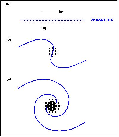 Fig.7
Fig.7Fig. 7. A schematic look at the "roll up" of a vortex sheet, where the shear line at the surface reflects a vertical sheet of vorticity. In (a), the vorticity (stippling) is spread out along the shear line; in (b) and (c), the vorticity becomes increasingly concentrated into discrete vorticity centers as the roll up proceeds. In this example, the sense of the vorticity is associated with a clockwise vortex, but the argument is independent of the sign of the vorticity.
Thus, if strong vorticity spread out along a line is present at some moment, it is likely that it will break down into a string of separate vorticity centers. This might have relevance for the origin of gustnadoes, and has been proposed for tornadoes as well (although tornadoes are more complex because it seems not all tornadoes develop in the same way). However, the notion that high vorticity tends to evolve into compact centers rather than being strung out along a line is relevant. See here for some updated thoughts about this.
As discussed in my vorticity primer, the issue of whether or not a vortex (i.e., a compact region of vorticity) produces a closed flow depends in part on the reference frame. If a moderately intense vorticity center is moving relatively rapidly, the ground-relative flow may not be a closed vortex. In fact, many weak to moderate tornadoes that move rapidly have damaging winds only on one side of the vortex. This produces a damage path that contains little or no direct evidence of rotation - all the damage may appear to be coming from more or less the same direction. This can lead some investigators to conclude that the event was not a tornado, but rather a microburst. The giveaway, however, is the existence of a long, narrow damage path . As the center of high vorticity moves along, it creates a narrow swath of damage.
If the damage is done by a moving center of high vorticity, resulting in a damage path that is narrow relative to its length, I am inclined to call it a tornado (or a gustnado, depending on the circumstances). I am not inclined to reject the tornado hypothesis simply because the damage is unidirectional, for reasons just given. That is, it is not obvious to me that the flow must be closed in a ground-relative sense for the event to be considered a tornado. If there are Doppler radar data, the storm-relative framework often will show a fair amount of symmetry in a vortex flow, even if the ground-relative flow is highly asymmetric.
A downburst (or microburst) creates a difluent damage path, because the winds are forced to spread apart as they interact with the solid ground ... the resulting divergence creates a fan-shaped damage region that may start out concentrated but rapidly spreads out and weakens. This is quite different from the damage produced by a concentrated vorticity center moving along.
On the other hand, people often are heard saying that such things as twisted trees, street signs, and other "indicators of rotation" imply that an event was a tornado. The scale of rotation in tornadoes is on the order of hundreds of meters, generally. A twisted tree can arise from purely straight-line winds if the tree's resistance to the wind isn't symmetric, for example - that is, the tree yields to the wind in a asymmetric fashion. Those doing damage surveys need to be aware of this all-too-common misunderstanding of the scale of tornadic vorticity; it usually is much larger than the structures and objects that are damaged, so on the scale of the structures , the damaging winds are "straight."[9]
As a final footnote to all of this, it seems to me that VORTEX and its follow-ons have underscored the relevance and value of observational programs. We've seen enough from the observations to cast real doubt on most of what we thought we knew. There have been those who considered the theory and numerical simulations to be so far advanced that observations could serve only to confirm the theoretical and numerical findings. In my opinion, VORTEX has invalidated this view, as described in my other VORTEX-related essay; the observations have shown the inadequacies and shortcomings of these approaches quite clearly. Moreover, the new data sets are revealing a host of new phenomena about which we know virtually nothing. The relevance of these new phenomena to tornadogenesis has yet to be shown, but it should be noted that we can't rule them out a priori as important factors, either. It appears that observational meteorology is in need of some support - shutting down our observational programs in favor of theory and numerical simulations would be a scientific tragedy (and travesty!!) for us all. Theory, modeling, and observations each have their own roles to play in science, and we can't make do without any one of them. Observational meteorology has been given far too little attention and value over the past two decades. Decreasing budgets have resulted in a disproportionate share of the burden has falling on observational facilities. I believe that VORTEX contains a message: the community should recognize that theory and modeling are not by themselves sufficient to carry our science.
Acknowledgments I appreciate the helpful input and information provided by my colleagues, Dr. Harold Brooks and Mr. Greg Stumpf. I also am grateful for feedback on the various versions of this essay by: Dr. Jeff Trapp, Dr. Dave Blanchard, Mr. Roger Edwards, Mr. Neil Stuart, Jim Means, and Mr. Billy Williams. I appreciate the permission to display copyrighted images by Dr. William Gallus and Mr. Dewayne Mitchell; please respect their copyright protection by not using those images without their expressed permission. Thanks also to Ken Howard for loaning me a slide scanner when I needed it.
Bluestein, H., 1988: Funnel clouds pendant from high-based cumulus clouds. Weather, 43, 220-221.
______, 1994: High-based funnel clouds in the Southern Plains. Mon. Wea. Rev., 122, 2631-2638.
Brooks, H.E., C.A. Doswell III, and J.E. Cooper, 1994: On the environments of tornadic and nontornadic mesocyclones. Wea. Forecasting, 9, 606-618.
Brown, R.A. (Ed.), 1976: The Union City, Oklahoma tornado of 24 May 1973. NOAA Tech. Memo. ERL NSSL-80 [NTIS Accession No. PB-269443/AS], 235 pp.
Cooley, J.R., 1978: Cold air funnel clouds. Mon. Wea. Rev., 106, 1368-1372.
Davies, J.M., C.A. Doswell III, D.W. Burgess, and J.F. Weaver, 1994: Some noteworthy aspects of the Hesston, Kansas tornado family of 13 March 1990. Bull. Amer. Meteor. Soc., 75, 1007-1017
Davies-Jones, R., and H.E. Brooks, 1993: Mesocyclogenesis from a theoretical perspective. In The Tornado: Its Structure, Dynamics, Prediction and Hazards (C. Church, D. Burgess, C. Doswell, R. Davies-Jones, Eds.), Geophys. Monogr. 79, Amer. Geophys. Union, 105-114.
Doswell, C.A. III, 1985: The operational meteorology of convective weather. Vol. II: Storm scale analysis. NOAA Tech. Memo. ERL MSG-15 [NTIS Accession No. PB83-162321], 158pp.
_______, 1991: Comments on "Mesoscale convective patterns of the southern High Plains." Bull. Amer. Meteor. Soc., 72, 389-390.
_______, 1996: What is a supercell? Preprints, 18th Conf. Severe Local Storms (San Francisco, CA), Amer. Meteor. Soc., 641.
_______, and D.W. Burgess, 1988: On some issues of United States tornado climatology. Mon. Wea. Rev., 116, 495-501.
_______, and D.W. Burgess, 1993: Tornadoes and tornadic storms: A review of conceptual models. In The Tornado: Its Structure, Dynamics, Prediction and Hazards (C. Church, D. Burgess, C. Doswell, R. Davies-Jones, Eds.), Geophys. Monogr. 79, Amer. Geophys. Union, 161-172.
Droegemeier, K.K., G.M. Bassett and D.K. Lilly, 1996: Does helicity really play a role in supercell longevity? Preprints, 18th Conf. Severe Local Storms (San Francisco, CA), Amer. Meteor. Soc., 205-209.
Forbes, G.S., and R. Wakimoto, 1983: A concentrated outbreak of tornadoes, downbursts, and microbursts, and implications regarding vortex classification. Mon. Wea. Rev., 111, 220-235.
Fujita, T., 1960: A detailed analysis of the Fargo tornadoes of June 20, 1957. Wea. Bur. Res. Paper No. 42, U.S. Government Printing Office, 67 pp. [out of print - :-( ]
Gall, R.L., 1983: A linear analysis of the multiple vortex phenomenon in simulated tornadoes. J. Atmos. Sci., 40, 2010-2024.
Glickman, T.S., 2000: Glossary of Meteorology, 2nd Ed., Amer. Meteor. Soc., 855 pp.
Huschke, R.E., 1959: Glossary of Meteorology. Amer. Meteor. Soc., 638 pp.
Idso, S.B., 1974: Tornado or dust devil: The enigma of desert whirlwinds. Amer. Sci., 62, 530-541.
_______, 1975: Density currents and topographical disturbances: A meteorological melange of intriguing interactions. Weatherwise, 28, 61-65
Lewellen, W.S., 1993: Tornado vortex theory. In The Tornado: Its Structure, Dynamics, Prediction, and Hazards (C. Church, D. Burgess, C. Doswell, R. Davies-Jones, Eds.), Geophys. Monogr. 79, Amer. Geophys. Union, 19-39
Moller, A., C. Doswell, J. McGinley, S. Tegtmeier and R. Zipser, 1974: Field observations of the Union City Tornado in Oklahoma. Weatherwise, 27, 68-77.
Purdom, J.F.W., and P.C. Sinclair, 1988: Dynamics of convective scale interaction. Preprints, 15th Conf. Severe Local Storms ( Baltimore, MD), Amer. Meteor. Soc., 354-359.
Rotunno, R. 1982: A numerical simulation of multiple vortices. In Intense Atmospheric Vortices (L. Bengtsson and J. Lighthill, Eds.), Springer-Verlag, 215-228.
Snow, J.T., 1978: On inertial instability as related to the multiple vortex phenomenon. J. Atmos. Sci., 35, 1660-1671.
_______, and E.M. Agee, 1975: Vortex splitting in the mesocyclone and the occurrence of tornado families. Preprints, 9h Conf. Severe Local Storms (Norman, OK), Amer. Meteor. Soc., 270-277.
Trapp, R.J., and R. Davies-Jones. 1997: Tornadogenesis with and without a dynamic pipe effect. J. Atmos. Sci., 54, 113-133.