Pet Peeves
of
Chuck Doswell
Last Update: 07 August 2016: ... added a new item to section B.
As usual throughout this Website, this
document is purely the opinions of C. Doswell and does not have any
official status. This is just a collection of my pet peeves, with
explanations of varying complexity to provide some rationale why this
or that bothers me. It will be updated and added to as things come to
mind. I welcome discussion about any or all of these at: cdoswell_at_earthlink,net (use the email link or replace "_at_" with the symbol it represents. I'm pleased that people actually do this from time to
time, so I've added a page that incorporates those discussions
without breaking up the flow of this page.
For the record .. this site is supposed to be
fun! I don't have the ability to impose my will on anyone, let alone
other scientists, dictionaries, glossaries, encyclopedias, or
whatever. I reserve the right to speak my mind, and I'm presenting
what I think are serious arguments, but the point of making them
accessible here is (at least in part) to have some fun (and to act as
a catharsis). So lighten up, folks.
Thanks to: Allan Rosenberg for providing me with the dictionary and
"The Elements of Style" links, as well as pointing out some of my own
mistakes herein ... also, to Alan Davis, Rachel Gavelek, and Steve
Ricketts for reminding me of some examples that bug me, too ... and
to those like Paul Sirvatka, Kai Esbensen, Jason Knievel, Matt
Parker, David White, Jim Means, and Brian Curran who actually have
responded with interesting arguments about my pet peeves.
For some discussions on this material, see
here.
A. Meteorological words, phrases, and pronunciation
1. kilometers
This word usually is pronounced "ki LO meters" ... with the
emphasis on the second syllable ... but this is not consistent with
the way we normally pronounce metric units. We don't say "cen
TI meters" or "ki LO grams," so I believe we should pronounce this as
"KI lo meters," in the same way we say "CEN ti meters" or "KI lo
grams."
2. baroclinicity
This word is too long. It is a noun describing the degree to which
a state is baroclinic. The equivalent noun describing the degree to
which a state is barotropic is "barotropy," so to be consistent we
should either say "barotropicity" or even "barocliny" ... since both the
former and the latter seem awkward, a compromise is "baroclinity,"
which I prefer to "baroclinicity."
3. short waves
The nearly universal application of this two-word phrase is to
short wave troughs . Strictly speaking, "short waves" include
both troughs and ridges, so a proper description should distinguish
between them, unless the intent is to include them both.
4. diffluence
The root of this word is "fluence" and the opposite of
"difluence" is "confluence." In analogy with
"divergence" and "convergence" ... the root of which is
"vergence" ... this should not be spelled "diffluence." Otherwise, we
should say "difvergence" to be consistent. Apparently, both spellings
are considered correct, so I prefer the spelling with one "f" for
consistency reasons. I have heard, but do not like, etymological
discussions rationalizing the two "f" spelling.
5. thundershower
The word "thundershower" is used often to imply a weak
thunderstorm, often in radio and TV weather broadcasts. I have heard
(via the Internet) such pathetic rationalizations as "The public
might panic if they heard they were going to experience a
thunderstorm, and so I use thundershower for ordinary
events." Without going into details, I find it monumentally unlikely
that the public would panic over the use of the right word:
"thunderstorm." They don't panic when hearing "tornado" in a weather
broadcast, either .. contrary to the discredited policy imposed on
the Weather Bureau (before it became the National Weather Service)
for many decades ... and the word "tornado" ought to be a lot scarier
than "thunderstorm"!
Strictly speaking, any occurrence of thunder, with or
without precipitation, is defined to be a thunderstorm ... the
intensity of the "storm" is not really implied at all by the
word "thunderstorm." Hence, the intensity must be indicated by
including an adjective (from "weak" to "severe"). The occurrence of a
thunderstorm ("T" in the pre-METAR format) accompanied by showery
precipitation (either "RW" for rain showers or "SW" for snow showers
in the pre-METAR format) might be considered a thundershower, of
course. However, that's not the typical context in which the word is
used ... or perhaps misused. Presumably, as the word is often
misused, a thundershower could be accompanied by tornadoes, large
hail, and damaging winds ... a "severe thundershower" ... a term that
is virtually never heard. Since a "thunderstorm accompanied by
showery precipitation" says nothing about intensity of either the
thunder or the showery precipitation, you would have to use an
adjective in addition to the word "thundershower" to convey properly
any sense of intensity. Now, what is the difference between, say, a
"weak thunderstorm" and a "weak thundershower"? Presumably, it could
be argued that one implies the presence of showery precipitation and
the other doesn't ... again, however, this is not the way the
word is used (abused?). I vote for expunging "thundershower" from our
vocabularies.
6. correlation and association
I often hear the phrase in scientific talks that "such -and-so is
correlated with this-and-that" when it is obvious from the
presentation that a statistical correlation analysis has not been
done. The word "correlation" is being used, carelessly, as a synonym
for "association." To have done correlation analysis involves, at the
very minimum, having stated the statistical character of the proposed
association (e.g., variable A is linearly correlated to variable B),
and having tested that as a hypothesis (e.g., computing a linear
correlation coefficient, which measures the degree to which A and B
are linearly correlated). If this minimal analysis (or more) has not
been done, then using "correlate" this way in a scientific
presentation is really misleading terminology. If the context is not
scientific, of course, this whole item is pure pedantry. But then
again, most of this Web page is pedantry! [See item
B.13, below, as well]
7. hectoPascals
It is a mystery to me what was wrong with millibars, a perfectly
good metric unit. It's not as if we need a nomogram or a calculator
in going from mb to hPa, after all! [In case you don't know it, 1 mb
= 1 hPa!] Of course, some purists want to argue that we should be
using kiloPascals, and that hectoPascals are some sort of abomination
by comparison. Another example of pure balderdash! I am in
favor of uniformity in units, but I don't think we need to be
dogmatic about it. After all, most of the readers of scientific
papers should be able to make the conversion from mb to hPa (or even
kPa, for that matter) without exerting too much effort ... I mean,
most of them do have PhD's, right? It's not at all obvious that our
science is being advanced in any way by converting from mb to hPa.
Therefore, being a stubborn person, I refuse to agree to this
insistence on pure SI units in publications.
8. accuracy vs. skill
When describing the quality of forecasts, the notions of accuracy
and skill often are treated as synonymous, but they are not .
Accuracy refers to the correspondence between forecasts and
observations, with increasing accuracy associated with increasing
correspondence. Skill, on the other hand, is associated with
the relative performance of the forecasting system in
question, when compared to some baseline forecasting system.
Baseline systems often used for measuring skill include: climatology,
persistence, and Model Output Statistics (MOS) forecasts; the idea is
to measure the improvement (or lack thereof) of the system in
question compared to the baseline system. An accurate forecast is not
necessarily skillful, and vice-versa.
9. "dynamics"
Forecast discussions among professional forecasters (and even
authors of scientific papers, who definitely should know better)
often use this term as if everyone knows what they are talking about,
when it seems to me that this is about as vague a description as it
is possible to offer. If this term is going to be used, at the very
least, authors should be careful to specify precisely what they mean.
I've discussed the word in a paper I published a while back (Doswell,
C.A. III, 1987: The distinction between large-scale and mesoscale
contribution to severe convection: A case study example. Wea.
Forecasting, 2, 3-16). I recommend avoiding its
use. Just describe the process(es) you think are occurring and don't
indulge in this vague description.
10. vortex/vortices
The singular word "vortex" has the plural form
"vortices" - this is another relic of Latin (an inflected
language) in English, that doesn't follow typical English rules
governing the formation of plural forms. Apparently, creeping
misusage has added some acceptability (in dictionaries) to the more
recognizable English plural form "vortexes" but my perception
(in my role as "schoolmarm" - see #C.7, below) is that this latter
form is not as proper as the Latin form. I have seen various
spellings, especially in the context of storms with multi-vortex
tornadoes. Hearing tornadoes referred to as having "multiple
vortices" prompts some to use "vorticy" (or some variant on this) as
the singular form - these are not even proper words in most cases.
11. solar insolation/incoming insolation
The word "insolation" is a contraction of "incoming
solar radiation" - therefore, both "solar insolation"
and "incoming insolation" are redundant.
12. Radar meteorology/Satellite meteorology
There may have been a time when the content of new observing tools
like radar and satellites was deserving of attention in its own
right. However, the time has long passed when "Satellite Meteorology"
and "Radar Meteorology" made any sense as subdisciplines, analogous
to "Tropical Meteorology" or "Synoptic Meteorology". Any particular
observational tool's contribution to understanding is no more than a
small part of any subfield within the general topic of
meteorology. A useful comparison might be to imagine a whole subfield
called "barometer meteorology" - this reductio ad absurdum
demonstrates the bankruptcy of the terms "Radar Meteorology" and
"Satellite Meteorology". Let's drop them from our vocabulary, please.
13. Optimality
I see the term optimal used a lot in scientific papers, and
it always seems to me to imply more than what the authors are
intending. Optimality is virtually always with respect to something;
that is, something has been optimized under a specific set of
constraints. The adjective optimal (as in "optimal analysis")
seems to suggest, however, that no one could ever do any better than
the result presented as being optimal. Nevertheless, in many cases,
the result can be improved, but in some way other than that
employed during the optimization. For instance, if an analysis scheme
is constructed such that it has maximum correlation with an ensemble
of observations, then it is certainly true that no analysis can be
constructed that has higher correlation with that specific ensemble
of observations. However, if the ensemble is changed, then some
different scheme might do better than that constructed from the
original ensemble. Moreover, the correlation with any
particular member of the ensemble of observations might
be increased well beyond that found when using a scheme derived by
optimizing with respect to the entire ensemble. Thus, the
optimality of a particular result needs to be understood to be
limited to the specific process of optimization. It should not be
interpreted to imply optimality in all applications and
circumstances.
14. Model "resolution"
When describing the "resolution" of a model, the grid intervals
(in space and time) typically are cited. Strictly speaking, features
on the scale of the grid intervals are not resolved by the
model! The smallest features that can be said to be "resolved" in any
meaningful sense of the term are those at twice the model's grid
interval, and even at that scale, the amount of information about
such small features is pretty limited (see Doswell, C.A., and and F.
Caracena, 1988: Derivative estimation from marginally-sampled vector
point functions. J. Atmos. Sci., 45, 242-253. available here. ). Thus,
this terminology should be discouraged, in my opinion. See also the published comments by [Grasso, L. D., 2000: The differentiation between grid spacing and resolution and their application to numerical modeling. Bull. Amer. Meteor. Soc., 81, 579–580.]
15. The Eastern "Seaboard"
I hear about this on The Weather Channel all the time ... and just
what the blue blazes is a "seaboard"? Is there a Western
Seaboard? A Southern Seaboard? If there's only the one
"seaboard," isn't giving it the description "eastern" rather
pointless? Why not just refer to it as "The" Seaboard?
16. ...
B. Meteorological/scientific
1. Air mass/frontal thunderstorms
An old idea is that thunderstorms are either of the "frontal"
sort, or the "air mass" sort. This terminology seeks to distinguish
between thunderstorms along fronts (zones of strong thermal
gradients) from other sorts of thunderstorms. The idea is that fronts
provide a lifting mechanism to develop convection, whereas other
thunderstorms develop within broad areas of more or less homogeneous
characteristics (air masses). It also is often taken to imply that
the thunderstorms develop more or less randomly in the "air mass," as
opposed to the organization provided by the front. I believe that
many thunderstorms develop outside of surface frontal zones (i.e.,
synoptic-scale fronts). Moreover, the development of thunderstorms is
never random ... they develop in particular places at
particular times for reasons that we may not be able to observe
and/or understand, but it is absurd to think that thunderstorms
develop, in effect, for no reason! Hence, I dislike intensely the use
of the term "air mass thunderstorm" ... actually, I find this whole
classification scheme to be well-removed from the reality of
thunderstorms. It's obsolete and should be discarded.
2. Propagation/movement
"Propagate" is a word that sounds erudite and scientific. "Move"
is common and used widely by non-scientists. However, "propagate" has
some very specific meanings, especially in regard to science and in
meteorology in particular. Movement is a perfectly good word
to describe how something is seen to be at some position, denoted by
the position vector Xo at time t =
to and is at some other position
Xo+dX at time
t = to+dt . What
we see as movement in the atmosphere can be the result of two very
distinct processes:
1. Something is simply carried
along by the flow (like a stick in a traveling stream) which has
velocity  . This is
called advection.
. This is
called advection.
2. The atmospheric "thing" we are seeing
dissipates at Xo sometime after
t = to, only to
re-form at Xo+dX by
t = to+dt , when next we observe it. This is called
propagation>.
It is impossible to watch an atmospheric process continuously and
so we can never be completely sure that the "something" we see at
t = to is "the same something" we see at
t = to+dt .
Real motion of atmospheric "somethings" involves both because what
we observe of atmospheric structure are observations of processes.
Fronts, lows, troughs, ridges, outflow boundaries, etc ... these are
all processes , not solid objects simply carried along
with the flow (as is a stick in a stream). Their movement typically
involves both advection and propagation. Since "propagation"
is a $5 word and "movement" is only a 5-cent word, many writers
believe it makes them sound scientific to write "propagation" when
the intended meaning really is "movement."
3. PVA=upward motion
I have provided a separate Website
discussion of this issue.
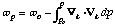
4. Divergence (convergence) causes vertical motion
I often hear folks saying things like "...the low-level
convergence (or, the high-level divergence)" caused upward motion to
appear. I also hear discussions about how upward motion results when
"upper-level divergence comes to be superimposed on low-level
convergence." These notions represent a basic misunderstanding of how
the atmosphere really works. Divergence/convergence and vertical
motion are connected by the Law of Mass Continuity. In constant
pressure coordinates, this takes the form:
 .
.
The vertical motion at some level is found by integrating the
horizontal divergence in the layer below that level.
 .
.
Thus, the vertical motion at some level depends on the layer
beneath it, and what the vertical motion was at the bottom of the
layer. This can get complicated, such that divergence/convergence at
any given level cannot be taken to infer anything about
vertical motion. Things are not always that bad, however.
Generally speaking, if there is upper-level divergence, the usual
situation is that there is upward motion beneath it (with convergence
at some level at the "foot" of the upward motion). See the
figure. If there is surface
convergence, there is upward motion above it, terminating somewhere
above the surface in a region of divergence. The simultaneous
existence of upward motion, with convergence at its base and
divergence at its top, is a necessary consequence of mass continuity.
The Law of Mass continuity is a diagnostic equation, that contains no
time derivative of vertical motion. Hence, it cannot identify
causes for vertical motion. There is a perfectly well-known
way to ascertain causes for changes in vertical motion ... it's
called the Third Momentum Equation. In constant height coordinates,
this takes the form:
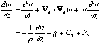 ,
,
where w is the vertical motion, r
is the density, p is pressure, g is the
acceleration due to gravity, C 3 is the vertical
part of the Coriolis force (C3 = 2Wucos f ) and
F 3 is the vertical friction force. The latter two
terms are usually neglected. There is no "convergence force" in this
equation! If you want to establish causes for changes in
vertical motion, [1] you
must look for them here, not in the Law of Mass Continuity.
5. "Subgrid" things that MUST have been there
In many situations, authors can't validate the existence of some
process or parameter (like PVA, or low-level moisture) because the
data simply aren't present, or the existing data don't reveal its
existence. Nevertheless, they insist that the process or parameter
was actually present, based on the events that occurred. Logically,
this is unacceptable in science ... they might be right, of
course, but it violates a fundamental principle in science to assume
that a particular hypothesized causative mechanism is present when
the event is observed, even when the data don't reveal that
mechanism! In effect, it is "changing the data to fit the hypothesis"
... a strictly forbidden exercise in science. If the event occurred,
and it is impossible to observed the hypothesized mechanism, then the
investigator must accept that the hypothesis could be wrong.
If additional data were obtained that might tend to confirm the
hypothesis, that's fine, but in the absence of such data, it becomes
impossible to say very much about the hypothesized mechanism. The
existing data can neither confirm nor deny the hypothesis in such
situations. An author can speculate that the hypothesis is valid, but
in the absence of information supporting the hypothesis, it can be no
more than speculation and must be identified as such.
6. "Triggering"
This word comes up often in the context of thunderstorms.
Thunderstorm initiation requires moisture, instability, and lift. The
concept is that somewhere within the atmosphere, a parcel can be
found that has buoyancy if lifted far enough to attain its Level of
Free Convection (or LFC, beyond which it is buoyant and can
accelerate upward with no further lift required). For this to take
place, there are 3 things needed: moisture, conditional instability,
and some process to lift a non-buoyant parcel to its LFC. Presumably,
the notion of lifting as a "trigger" assumes the presence of moisture
and instability sufficient to allow some parcel to have an
LFC, and it is only awaiting the lift.
In the absence of any one ingredient of the necessary triad, no
thunderstorms will occur. So which is the "trigger" ... if any two
are present, in the absence of the third, the thunderstorms await the
missing ingredient as a "trigger," do they not? Which ingredient is
most important? Trick question! ... no one of the three can be most
important. Thunderstorms always require all three. Is it always found
that moisture and instability gather in the absence of lift, as
opposed to other combinations? I think not. Moisture and lift often
occur in the absence of conditional instability ... its arrival could
then logically be considered a "trigger"! Instability and lift often
occur together in the absence of moisture. Arrival of moisture could
then be viewed as a "trigger."
I prefer to consider the question of convective initiation as one
of the simultaneous presence of all three basic ingredients and forgo
the idea of "trigger" completely. If we must have a "trigger"
it is not obvious to me that it must always be the "lift" ingredient!
7. Overrunning
I have provided a separate Website
discussion of this issue.
8. Difluence = divergence
Difluence is simply the spread of streamlines downstream. If a represents the wind direction (as an angle
relative to some standard direction ... in meteorology, the
convention is that a wind from the north is zero degrees, and the
angle increases in a clockwise direction ... in a so-called
natural coordinate system (s , n ) where
s is the direction along the flow and n is the
direction normal to the flow (and to the right of the wind), it can
be shown that divergence is given by
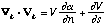 ,
,
where V is the wind speed. The difluence part is
given by only part of the first term:  ... therefore, the difluence of the flow cannot be
equivalent to the divergence, although they clearly are related. It
is a common mistake, however, to equate difluence with divergence
(and then go on to infer vertical motion, another mistake).
... therefore, the difluence of the flow cannot be
equivalent to the divergence, although they clearly are related. It
is a common mistake, however, to equate difluence with divergence
(and then go on to infer vertical motion, another mistake).
I'm mostly mystified by why anyone thinks difluence is a useful
parameter, anyway, at least in the context of assessing the
favorability of an environment for convection. Historically, it seems
that difluence is a proxy for upward motion, through the dubious
inference of divergence aloft. It strikes me as more useful, more
direct, and more physical simply to find the vertical motion than to
infer its presence from difluence at high levels.
9. Fronts always analyzed at windshifts
This has been discussed at length in the following paper: Sanders,
F. and C. A. Doswell III, 1995: A case for detailed surface analysis.
Bull. Amer. Meteor. Soc., 76, 505-521, which can be
found here.
10. Oklahoma/Texas vs. the world
I am constantly hearing nonsense like "Oh, the storms you guys see
in Oklahoma/Texas! We never see storms like that here
[where "here" is another state, another region, another country, or
whatever]!" Another version of this is "Well, the storms we see
here are different than the ones you guys have in OK/TX!" This
is really galling, and implies that somehow the laws of physics are
different in Oklahoma/Texas than in the rest of the world. The
atmosphere does not have a watch, a calendar, or a map ... if
conditions for a certain type of storm are created at an atypical
time, date, or location, then that type of storm can and will occur.
There can be little doubt that the conditions for tornadic supercells
are not created with the same frequency around the world, but there
is also little doubt that tornadic supercells can and do occur
outside of Oklahoma and Texas. Believing that they cannot occur
outside of OK/TX makes you vulnerable to unpleasant surprises!! If we
scientists here in Oklahoma have committed any error, it is that we
often have chosen to write papers about only a small minority of
storms - tornadic supercells are not common even in OK/TX.
There are lots of other storm types here, and not all tornadoes in
Oklahoma come from "textbook" storms. The new Doppler radars are
providing clear evidence that supercells (and, occasionally,
tornadoes) occur in many parts of the U.S. where they were heretofore
believed to "never happen"! There is abundant new evidence of their
occurrence in Europe, Australia, Africa, South America, Asia -
around the world.
Note added 24 Feb 2000:
Part of the persistent notion I hear about "storms are just
different here!" is apparently a convolution of the
environment with the storms; that is, a lack of
distinction between the processes that create the conditions for
convective storms and the convective storms themselves. It's hard for
me to imagine, otherwise, what folks might mean by the
assertion that storms in some location (or at some unusual time of
the year, or at an usual time of day) are different: Do their
updrafts go down? Do their mesocyclones rotate anticyclonically? Does
their rain fall upward? If you are going to assert that your storms
are different, it behooves you to be very precise about how
they're different! What is it about your storms that makes
them different from mine? I maintain that the environmental
conditions making a certain event possible are logically and
physically distinct from the process that those conditions
support! Taking the "holistic" view that a storm should not be
separated from the conditions giving it birth is, in my opinion, not
a useful perspective.
There can be no doubt that the frequencies and
intensities of storms vary as a function of location, time of
year, and time of day ... these variations are associated with
differences in the frequencies of the environmental conditions giving
rise to certain convective storm behaviors. As seen
here, for example,
there can be large spatial and temporal variability in these
frequencies associated with variations in the meteorology, but this
does not mean that when the conditions for a certain storm behavior
are brought together, then something different happens because of the
location, the time of year, or the time of day. The response to those
conditions ... the convective storm ... is essentially the same the
world over.
Now storms have a great number of superficial differences, not
altogether unlike the fact that every person has a unique set of
fingerprints, but that doesn't mean that everyone is
fundamentally different from everyone else. No one would argue
that Joe is a different type of human being from John because they
have different fingerprints! There may well be subsets of humans that
share certain characteristics and it might be possible to develop a
taxonomy (classification scheme) based on one or more of these
characteristics. Since we all have different fingerprints, this would
not be a very useful classification scheme ... each class would have
only one member!
In the same way, each storm is probably a unique event at some
superficial level (no storm is probably exactly like another storm),
but from the point of view of a meteorologist, there is no reason to
believe that a supercell in Ethiopia is somehow fundamentally
distinct from a supercell in Oklahoma, or that supercells in the fall
have to be distinguished from those of the spring. A taxonomy based
on the geographic location (or time of year, or time of day) is
unlikely to produce anything particularly useful in terms of
distinguishing convective storm types. A supercell develops because
the ingredients for a supercell were brought together ... if they
came together in an altogether different synoptic setting in one
place versus another place, my argument is that the supercell is
basically the same: the storm is a convective process, with updrafts
and downdrafts, precipitation and winds, a mesocyclone, etc. Unless
someone can point to some specific storm characteristic and
show that it is uniquely associated with a location, a time of
year, or time of day, I believe the burden of proof is on the
shoulders of those who are asserting such a distinction.
11. The Fujita scale's misinterpretations
[7]
Prof. Fujita's tornado rating scale, the so-called
Fujita
scale, has invited misinterpretations virtually since its
introduction. Let me hasten to say at the outset that I believe that
the F-scale is a real contribution to our science and Prof. Fujita
deserves the recognition that he has gotten through its introduction.
Having some reasonably systematic way to estimate tornado intensity
strikes me as a real step up from treating all tornadoes as if they
were the same, which is how things were before the F-scale was
introduced. However, there are three important aspects of the F-scale
that lead frequently to misinterpretations:
a. The F-scale category / windspeed
relationship
The notion of the F-scale measuring the intensity of
tornadoes is connected to the windspeed estimates assigned by Prof.
Fujita to the categories. Although I have no way of knowing just what
Prof. Fujita was thinking, it seems that the F-scale categories were
originally designed to provide a sort of "bridge" between the
Beaufort wind scale and the Mach scale. That is, F-1 was chosen to
represent Beaufort force 12 (minimal hurricane force winds), and F-12
would represent Mach-1. Of course, Fujita believed that F-5 was
incredible and F-6 was literally inconceivable, so that F-6 through
F-12 were just empty placeholders on this "bridge" between speed
scales. Therefore, strictly speaking, it seems that the F-scale was
"designed" to be a windspeed scale.
I have written on this topic elsewhere [See: Doswell, C.A., III
and D.W. Burgess, 1988: On some issues of United States tornado
climatology, Monthly Weather Review, Vol. 116, pp.
495-501]. The hangup with the F-scale as a windspeed scale is that
there was no way to determine windspeeds in tornadoes at the time of
its development. Even now, obtaining tornadic windspeeds near the
surface[8] is pretty much
impossible in most cases. The boundaries between F-scale categories
in terms of wind were fixed by the fit between the Beaufort and Mach
scales, not by an accurate knowledge of the windspeeds needed to
produce a given level of damage to a frame home. As noted in the
article cited above, the real-world application of the F-scale
has always been in terms of damage, not windspeed.
Unfortunately, the relationship between the windspeeds and the damage
categories has not been tested in any comprehensive way, for several
reasons:
- The damage categories are associated virtually totally with
frame home structures. There are many, many variables that
influence the amount of damage to a frame home, even given
a constant windspeed. Home construction techniques, variability in
the structural integrity depending on the direction of the
impinging wind, the presence or absence of missiles in the
airflow, the steadiness and/or duration of the wind, etc. Even if
we only consider damage to frame homes, it is very difficult to
assess the windspeed, especially after the event (when facts about
construction details may no longer be available, owing to the
damage itself).
- When frame homes are not affected, there is essentially
no way to assign F-scales at all. What windspeed does it take to
make a particular automobile or other vehicle (e.g., tractors)
become airborne? What windspeeds result in the embedding of straws
into wooden poles? What windspeeds cause a particular damage level
to a cornfield? What windspeeds are needed to uproot a mesquite
tree? What windspeeds cause the stripping of pavement? These (and
other) specific items have been used in the past to assign
F-scales, but in reality we have virtually no factual basis for
assigning either F-scale or windspeed estimates to such damage
events. In order to do this right, we would have to do some sort
of controlled experiment in virtually every conceivable tornado
situation! This is a practical impossibility. In cases where
damaged structures are engineered structures, it may be
possible to estimate what winds caused a particular amount of
damage, but there are many factors besides construction details
that can influence the damage.
- The processes by which damage occurs in a tornado are very
much situation-dependent and hard to simulate, either by
computer-based numerical models or in wind tunnels. We know
precious little about the real structure and evolution of windflow
in a tornado. And real events are complicated by the presence of
missiles in the wind, by the details of how damage occurs, etc.
Wind tunnel studies, computer simulations, or shooting objects out
of air cannons against simulated structures and other targets can
help, but such efforts are unlikely ever to be comprehensive of
all the potential factors associated with a particular item of
damage.
- Engineers tend to assign variations in tornado damage to
variations in structural integrity. Meteorologists tend to assign
the same damage variations to variations in windspeed. The actual
damage variation is certain to be a variable mixture of these
factors, but it is very difficult to separate them, especially
after the fact.
I could go on, but the main point to understand about the F-scale
is that the damage vs. windspeed relationship has never been tested
thoroughly. With all due respect, the windspeed limits to the F-scale
categories are simply Prof. Fujita's best guesses . For all I
know, they might be quite accurate, but since they have not
been "calibrated," it seems quite inappropriate to give them complete
credence.
b. The implication of precision
|
F-Scale
|
F0
|
F1
|
F2
|
F3
|
F4
|
F5
|
|
Windspeed (mph)
|
40-72
|
73-112
|
113-157
|
158-206
|
207-260
|
261-318
|
By providing such specific numbers, the category boundaries imply
a high degree of precision. That is, for example, it appears that a
windspeed of 112 mph produces qualitatively different damage than a
113 mph windspeed; i.e., F1 vs. F2. This is absurd, of course. If we
were to do a calibration of the windspeed-damage relationship, we
would not find such hard boundaries between categories, with precise
thresholds. Instead, we would find "fuzzy" boundaries ... rather than
"top hats" we would find something resembling "bell curves." [See my
discussion on this here.]
That is, the windspeeds associated with a particular type of damage
might well have a peak at some value, but the range would not
drop to zero at values somewhere above and below that peak ...
instead, the range would tail off at both ends. Sometimes,
circumstances would create a particular type of damage at windspeeds
higher or lower than the numerical ranges currently associated with
the F-scale categories.
I'm confident that Prof. Fujita does not believe that a 157 mph
wind causes quite different damage from a 158 mph wind (F2 vs. F3),
so this implication is a misinterpretation of the F-scale, even
disregarding the lack of precise windspeed-damage calibration. I
often see media reports after a tornado has been given, say, an F4
rating, that the tornado "packed winds of 260 mph!" The media tend to
push everything to the high end of the range, apparently because it
sounds more impressive. If they do moderate this, it usually
is to something like "... winds of up to 260 mph!" ... as if
the specific number of 260 mph is set in stone. This is quite common
in media "scientific" presentations, such as the Discovery Channel's
"Raging Planet: Tornadoes" program, first aired in August of 1997.
c. The absolute maximum tornado windspeed
This topic is a popular item for discussion, even though it
reminds me somewhat of debates regarding angels and pinheads. There
is no reason to believe that the figure given for the top of the F5
category, 318 mph, has some scientific credibility as the maximum
tornadic windspeed. It, like the other numerical values, is simply
Prof. Fujita's best guess. Of course, Prof. Fujita's best guess ain't
chopped liver, either! It's quite possible that if an absolute
maximum windspeed can be given, the figure of 318 mph might well be
in the right ballpark. However, we don't know for sure if such a
maximum can be provided in any sense other than theoretical, and even
if it could, it seems unlikely to be 318 mph, exactly. We have so few
observations of tornadic windspeeds by any means whatsoever that it's
silly to speak of having established the absolute maximum windspeed
figure down to within a precision of 1 mph.
It is pretty certain, however, that the peak tornadic
windspeeds are not as high as 500 mph, and certainly do not
approach or exceed the speed of sound. Years ago, in total ignorance,
numbers like these were mentioned but no longer are considered
credible by most tornado researchers.
Some authors (notably, Prof. Brian Fiedler at the University of
Oklahoma) have proposed a "thermodynamic speed limit" for tornadic
windspeeds. This is no more than a point of departure for some
theoretical discussions, and certainly is completely unrelated to
Prof. Fujita's figure of 318 mph. It seems likely that the windspeeds
in real tornadoes regularly exceed this "speed limit", albeit only
briefly.
Recently, in light of the 3 May tornado in the Oklahoma City
Metroplex, claims of observing windspeeds equalling or exceeding this
318 mph figure have been made. Irrespective of the merits of those
claims, if we assume for the sake of argument that they're accurate,
does this raise the possibility of an F6 tornado? Although Fujita
included such a possibility in some of his work, it is not at all
clear what sort of damage to look for to confirm the existence of
such an event (in the absence of measured windspeeds). The
uncalibrated character of the F-scale, especially at the high end,
makes this discussion about the existence of an F6 tornado seem very
silly to me, even if measured windspeeds are available. Formally, a
319 mph windspeed would qualify, of course. I've already dealt with
this absurdity earlier in this discussion. Generally, I am opposed to
this sort of sensationalism (pandering to the media) in any
meaningful science-based discussion of tornado intensity. Also, see here
for a discussion of "records" about tornadoes.
12. Dei ex machinae
A recurring theme in "explanations" of the weather is the nice,
simple causative mechanism that provides a simple answer to a complex
question. If a weather event of some sort (e.g., a tornado) happens
to hit in a place or at a time that is climatologically unusual, then
it is attributed variously to such things as:
- Global
warming
- El Ni�o/Southern Oscillation
- Gravity waves
- Atomic bomb tests (out of vogue, at the moment)
- Conditional Symmetric Instability
- Clashing air masses
- Sunspot cycles (not as popular as it was)
- The most recent volcanic eruption
- Elvis Presley, UFOs, Ill will on the part of the Deity, etc.
[all clearly outside the domain of "establishment science"]
The current favorite is El Ni�o. What will it be next year?
Alternatively, there are implications a particular deus ex
machina is going to result in some unpleasant condition in the
future ... i.e., a prediction is made. The recurrence of
weather events (e.g., the many rainstorms in the U.S. central plains
during the summer of 1993, or a particular number of tornadoes in a
given year, or whatever) also can be attributed to such
oversimplified "explanations."
It's not that a particular instance of a weather event is
unrelated to one (or more) of these factors ... it's simply
that in many uses of this sort of "pat" explanation, vast
oversimplification (perhaps to the point of being ludicrous) is being
done. Certainly, for example, the El Ni�o process alters an
important factor in the world's weather: the sea surface temperature
distribution. However, to make the statement that a particular event
(past, present, or future) is related to the El Ni�o via a
chain of causality is hard to establish with any confidence ... for
some events, it might even be literally impossible to show cause and
effect. The El Ni�o phenomenon's relationship to the observed
weather (say, a heavy rain event in California, a tornado in
Mississippi, or a drought in Australia) is clouded by a number of
factors:
- The global circulation at the time of the onset of the El
Ni�o
- The characteristics of that particular El Ni�o event
... they are not all the same!
- The difficulty of obtaining clear and unbroken chains of
causality in nonlinear systems (most all geophysical processes
involve nonlinearity)
It's entirely possible that a given El Ni�o did have an
effect on one or more events, but the challenge is to show that the
El Ni�o was the primary causative factor ... tough to do. Any
of the dei ex machinae might well be a factor in a meteorological
event, and some of them can have pretty compelling evidence of
statistical associations, but statistical evidence is not
proof of cause and effect (see the next item). As another example,
volcanic eruptions certainly have the potential to affect the global
temperature, and there even is a cause and effect link to global mean
temperature that has been established with some confidence. But not
every volcanic eruption has the same effect. There are many
factors that can alter the meteorological outcome of a volcanic
eruption. Attributing a particular event to the eruption of a volcano
is risky unless it can be shown unambiguously to be associated
with the known causality chains.
Naturally, the media often engage in this sort of simplistic
exercise, but even scientists who should know better do so from time
to time. For a rational view of El Ni�o, see
this
page.
13. Statistical association
I really shouldn't have to go into this, but it surfaces a lot in
the media, and occasionally even in the scientific literature. The
existence of a strong statistical association does not imply
cause and effect. Any text in statistics will emphasize this, but if
event A is strongly associated with event B, it is tempting to
presume that A explains B or vice-versa. As a somewhat contrived (but
still useful) example, it is easy to show that virtually every
criminal has, at one time or another, eaten at least one pickle. If
we did a statistical analysis of the data, there might well be a near
perfect correlation between crime and having eaten at least one
pickle. Does it make sense to infer that pickles cause crime? Perhaps
it might better be said that we have asked the wrong question ... it
is not uncommon that the questions we wish our data to answer have
been posed improperly. Perhaps if we did a study that included
non-criminals, we also would find that virtually all of them
had eaten at least one pickle, as well . This would make it pretty
clear that pickles are unlikely to be the source of criminal behavior
(or we have a large number of unrecognized criminals?). The data and
their statistical analysis may have been all "by the book," but the
problem was ill-posed. If an association can be shown, then it
might be a clue to causality, but there must be a plausible
causal connection before it is even worth pursuing the issue in
detail. Is there a plausible reason that explains why eating a
pickle would lead to a life of lawlessness? Fun aside, even good
scientists who should know better have fallen victim to this trap!
14. "Obstacle" flow around storms
A recurring theme associated with severe storms is the notion that
the storm (whatever might be meant by "the storm") acts as an
obstacle to the flow, in mid-troposphere. The available observations
certainly look as though the storm is an obstacle, and there
have been studies making extensive use of these observations to make
statements about the vorticity source for the counterrotating
vortices seen on the flanks of the updraft. This is an interesting
analogy , but it is important to understand that the
appearance of the flow does not necessarily mean that the flow
dynamics are identical to those associated with solid
obstacles embedded in a fluid flow.
The short version of the problem with the obstacle flow
analogy is the following. When there really is a solid obstacle in
the flow, vorticity is generated in the viscous boundary layer
associated with the solid obstacle. This vorticity is shed into the
wake of the flow and is the source of the vorticity in the
counterrotating vortices. Thus, even if the ambient flow is
completely uniform, containing no ambient vorticity whatsoever, the
basic elements of obstacle flow will generate these vortices. Severe
thunderstorms are associated with environmental flows having
considerable vertical shear and, therefore, considerable vorticity
about a horizontal axis. It is generally accepted now that the
counterrotating vortices associated with severe thunderstorms arise
from tilting of this substantial ambient vorticity. Thus, the
similarity in appearance is only coincidental to the major
differences in the dynamics of the vortices associated with the
interaction between the updraft and its environment.
The long version can be found here,
in published comments by R. Davies-Jones, me, and H.E. Brooks on a
paper by R. Brown in the Journal of the Atmospheric Sciences.
15. Cold advection and "cap" elimination
It is a tired old clich� that when there is a "cap" that is
restraining convective initiation, lower mid-tropospheric (i.e.,
around 700 mb) cold advection will help remove that cap. There are
several problems with this argument. First of all, cold advection at
some level is associated with subsidence at that level, in virtually
all cases.[2] This can be
seen in my discussion of (ugh!)
"overrunning" .. see
this
figure. Subsidence is not a very good way to remove a cap (see
below). Second, it often happens on the Great Plains that the reason
for the cap is the advection of an elevated mixed layer (EML) from
the higher terrain to the west. This superposes high lapse rates over
low-level moisture all right, but it also can produce a strong
"capping" inversion that prevents release of the convective
instability in such a sounding. In these situations, then, the
morning 700 mb map often has a thermal ridge somewhere on the High
Plains ... if this were further east, it is possible that the
advection of this feature would push the thermal ridge further
eastward. On the Great Plains, since the thermal ridge at 700 mb is
not all that far above the terrain, a significant contribution to the
temperature at 700 mb is the solar (diabatic) heating. With the solar
heating during the day, it is not uncommon in these situations to
find that the thermal ridge has not moved very far at all by evening,
and may even have backed up ... the temperature changes that the
morning pattern of advection implied have not happened.
Note that on a pressure surface, isotherms are also isentropes ...
that is, on a p-surface, the temperature contours are also potential
temperature contours. Consider, then, the local change in potential
temperature, q, which is given by
the following:
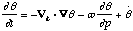
where is the diabatic contribution.
That is, local changes in (potential) temperature on a pressure
surface result from (1) horizontal advection, (2) vertical advection,
and (3) diabatic processes. Since cold advection results in
subsidence, in a stratified atmosphere (potential temperature
increases with height), the associated subsidence actually
counteracts the effect of the thermal advection on the pressure
surface. On the High Plains, the diabatic warming effects are often
large enough to counteract the cold advection entirely.
I don't want to make a categorical statement, but I can't think of
a single case where one could attribute unambiguously the initiation
of severe convection on the Great Plains to cap removal through cold
advection at 700 mb. If such events can be found, I believe them to
be atypical; by and large, this idea is a clich� that is not
consistent with the facts.
16. The "convective temperature"
This is a widely-used term; it stands for a surface temperature
that corresponds to the elimination of a "cap" (i.e., the removal of
all of any negative area associated with ascending low-level parcels)
by insolation (see A.11, above). Presumably, it is believed by users
of this term that deep convective initiation will be delayed until
the "convective temperature" is reached, after which deep convection
will begin. If this was a valid concept, then deep convection should
begin by cloud flashing into existence over big chunks of real
estate, all at the same time. What we really see is that deep
convection usually commences as isolated convective clouds, perhaps
at a few places along a line, usually well before the
attainment of the "convective temperature". Sometimes, however, the
"convective temperature" is reached and nothing happens. The implicit
model associated with this term is that deep convection is initiated
solely by elimination of the negative area through solar heating.
Since the reality is quite different from the scenario developed from
this implicit model, consider why this is so.
a. There typically is considerable horizontal
inhomogeneity in the real world. The "convective temperature" derived
from a sounding can only be interpreted legitimately as representing
the unique place and time when the sounding was taken ... it may or
may not represent a wider space/time volume than that. Hence, the
"convective temperature" cannot be taken literally unless (a) the
convection actually begins at the sounding site, and (b) the real
evolution of the sounding corresponds to that described by the model
of how that sounding would evolve under the influence of solar
heating. If a sounding evolves differently than how this model
predicts it will under the sole influence of solar heating, some
other process is happening for which this simple model fails to
account. Thus, it is also easy to understand how the "convective
temperature" could be reached with no convection ensuing.
b. In virtually all cases, deep convection is initiated by
processes that lift parcels first to their LCLs and then to their
LFCs.[5] In the real
world, deep convection is not initiated by solar heating alone,
although that heating certainly reduces the negative area that must
be overcome by some lifting process. Some
subsynoptic-scale[6]
process (e.g., ascent associated with a front) is that which
typically raises parcels to their LFCs, initiating deep convection.
The spatial and temporal variability of the processes that ultimately
result in deep convective initiation means that the first deep
convective clouds will appear at some point (or a limited number of
points) in time and space, rather than in some region that has
attained its "convective temperature".
The concept of the "convective temperature" is one that
contributes nothing of value in forecasting, owing to its failures as
described above, and it perpetuates an improper understanding of deep
convective initiation. Thus, I recommend that this term be rejected
and used no more.
17. The gradient wind
This one might well raise some hackles ... my objection to this
one is inherited from one of my career's biggest influences, Prof.
Walter J. Saucier. For those of you who recall your elementary
dynamics, the so-called gradient wind "balance" is similar to the
geostrophic wind balance, except it considers forces associated with
the curvature of the flow; that is, those forces precisely
normal to the wind flow. Textbook treatments of the subject
talk about it in some detail, often including an elaborate discussion
of the four solutions associated with positive and negative radii of
curvature combined with both real and imaginary roots to the
quadratic equation that describes gradient flow.
First of all, the gradient wind defined in this way cannot be,
strictly speaking, a balanced wind at all! Since the flow has
curvature, it is accelerated, by definition. Accelerated flows
are most definitely not in balance, right? But Walt's objections
don't stop there. Walt felt, and I agree, that making the assumption
of zero tangential acceleration while allowing for normal
accelerations makes the elaborate exercise of developing four
specific solutions to the formula for "gradient wind balance" seem
rather contrived. We make a great fuss over this mostly mathematical
exercise, for no truly obvious value other than to show off some
undergraduate mathematics. I'm willing to keep this one in the
lexicon, but it's not something that offers me much; the notion that
it represents a "balanced" flow is clearly incorrect! To the extent
that it's observed that flow around troughs is typically
subgeostrophic and that around the margins of ridges can be
supergeostrophic, the idea of gradient flow offers a lowest-order
explanation for that observation. Beyond that, it's mostly a
mathematical curiosity, as I see it.
18. 2000 thunderstorms at any given time
This has got to be one of the most frequently-quoted numbers in
the weather business. Even I've used it. But upon what is it based?
Whose study underpins this? It turns out that the seminal paper that
"backs up" this estimate is by C.E.P. Brooks in 1925: The
distribution of thunderstorms over the globe. Geophys.
Memoirs, No. 24 (4th No. of Vol. 111), 147-164. The paper says
"... there will be in progress at any one moment about 1,800
thunderstorms in different parts of the world." (at the end of
section 4). This study proceeded by considering the reporting of
thunder at surface observation stations (at and prior to 1925,
obviously), making a number of assumptions about unobserved events
over the oceans, in sparsely populated regions, etc., to arrive at
this final number. Since this paper, everyone just quotes the figure,
without ever being concerned for its validity in the modern era.
Given the information available in 1925, this might well be a
reasonable figure, but in view of today's data and a modern
understanding of thunderstorms, this hackneyed phrase has lost its
meaning. What constitutes "a thunderstorm"? Is it a cell, a
convective system, a radar echo, a satellite signature, or what?
Using today's data (radar, satellite images, lightning detection
networks, etc.) how would we verify this number? A squall line (or a
convective system, or a radar echo, or a satellite signature, or
whatever) can produce thunder observations at a number of surface
stations during a single day. Is the squall line one
thunderstorm, or many? Almost certainly, no one would consider
it to be a single thunderstorm, but how
many? Where would we have to draw the boundaries of
a "thunderstorm" in order to validate this number of 2000 (or 1800)
worldwide, on average, at any given moment? I know of no way to do
this.
I'd like to advocate that we stop using this silly, superannuated
number, and defer inserting any such estimates in textbooks, etc.,
until we can arrive at a number that makes some sense in
today's world, validated with modern datasets.
19. "Top ten" lists of meteorological events
For some reason (too much time spent watching David Letterman?),
as the century comes to a close, there seems to be an obsession with
creating "top ten" lists of storms and other meteorological events.
This has generated a lot of controversy over what events to include
in such lists. Basically, I consider all of this to be no more than
entropy generation, without any associated value, except perhaps to
remind people of important past weather events. I offer the following
thoughts:
- Why "top ten" lists? Basically, because we humans have ten
digits on our hands! The particular choice of the number 10 is
simply an accident of evolution.
- By what measure are we rating meteorological events? It
seems we can't agree on objective measures of importance,
so any list based on any particular measure is simply one person's
opinion about what "important" means. Anyone is entitled to an
opinion, of course, and perhaps some people's opinions might be
viewed as "more valuable" than those of others, but that certainly
is arguable. Several lists of events (not necessarily limited to
exactly 10 events!), identified directly with various different
measures of significance might be more meaningful than a single
"top ten" list.
- Meteorological significance is not necessarily related
to societal impact. Events that make the "top ten" lists
tend to be dominated by those with large societal impact, rather
than the objective meteorological significance of the events. This
is not necessarily bad, depending on what you choose to consider
important (see previous item), but meteorologists inevitably see
things differently than the rest of society, because they have
professional biases. Further, events can have a large impact on
meteorology without being notably large or important events by any
other measure... e.g., the tornado that hit Tinker AFB on the day
of the first tornado forecasts of the modern era in March of 1948.
- Does creating these lists accomplish anything of
substance? In my opinion, only to the extent that (a) it forces us
to go back and view the actual record of past events, and (b) it
makes the general public aware that events of the recent past are
not without precedent, something that many citizens apparently
don't know. Beyond this, "top ten" lists are without value.
- There is a very real tendency to emphasize the events with
which we are familiar because they happened in the recent past. If
something bad happened a generation ago, or longer, the perception
of its importance tends to decrease. This temporal myopia
is exaggerated by the fact that the way we analyze events today is
different from the way they were analyzed in the past.
Facts and figures that we now deem important enough to record may
not have been recorded at all one hundred years ago, or might not
have been recorded in the same way. Hence, our objective knowledge
of past events is always clouded, leading many to conclude that
recent events are more important.
- Most of the "top ten" lists I've seen have been characterized
by this emphasis on recent events, leading the ignorant to
conclude that the weather is getting worse ... dare I say by
global warming? Although global warming (or any other fashionable
deus ex machina, see item B.12, above) might be
altering the world's weather so as to increase the frequency of
bad storms, that is not a scientifically valid conclusion to draw
from somebody's "top ten" list!!
20. The "tropical connection" cloud band
From time to time, in the infrared (sometimes, the so-called
"water vapor" band) satellite imagery, a long cloud band can be seen
extending from the tropics well into midlatitudes. This is often
referred to as the "tropical connection," or "tropical moisture." or
some similar jargon. The implication is that the cloud band
represents a flow of highly moist tropical air into some region in
questions. However, the clouds that compose the band visible in the
satellite imagery are present in the middle and upper troposphere,
where the actual mixing ratio of the air is pretty negligible. The
amount of moisture they contribute is essentially trivial. These
cloud bands may be associated with a comparable flow of
low-level moisture, or they may not. The mere presence of the
band does not imply any meaningful contribution to the moisture
content of the air that is potentially involved in deep, moist
convection. It's bad enough when media broadcasters use such sloppy
terminology, but occasionally even meteorologists do so.
21. The clash of air masses
In the context of the development of severe storms, the phrase
"clash of air masses" (typically between warm and moist vs. cold and
dry) is often invoked to "explain" the occurrence of severe
thunderstorms and tornadoes, notably on the Weather Channel. This is
an idiotic oversimplification. Air masses "clash" all the time, even
when severe thunderstorms are only the remotest of possibilities. If
this were actually an "explanation" of the occurrence of severe
thunderstorms and tornadoes, we ought to have such violent weather
almost continuously, and only along frontal (and/or dryline)
boundaries. This balderdash is often spouted by the media in their
misguided efforts to "simplify" the explanations of events to the
public.
22. Improper assessment of vorticity advection
(a) It's regrettably common to attempt to assess vorticity
advection by counting the number of units of vorticity traversed by a
moving air parcel. This is incorrect. In meteorology,
advection of any quantity, say Q, is given by:
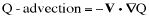
where V is the vector wind. Clearly, the amount of
Q-advection depends on the magnitude of the wind component parallel
to the Q-gradient vector, and the magnitude of the Q-gradent vector
itself. Advection is an instantaneous quantity; that is, it's
calculated at one instant of time, at some specific point in space,
according to the formula above. Obviously, advection can vary with
both space and time, and can be positive, zero, or negative..
If changes in Q are found by following an air parcel, what is
being calculated is:
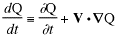
On the left-hand side of this is the total (or substantial)
derivative associated with the moving parcel. On the right-hand side
are two terms: the first is the partial derivative of Q with respect
to time (measured at a point), and the second is obviously the
advection (multiplied by a minus sign) also calculated at a point.
Therefore, at some point in space, at an instant of time, the total
derivative  is equal to
the sum of two contributions: the change associated with
whatever processes are changing Q at that particular point, and the
change associated with the wind bringing in different values of Q to
that point. Hence, changes in vorticity seen by following a parcel
are not just due to advection, and they will be of the wrong
sign to determine the advection properly! To see this latter point,
suppose the air flow is from high values of Q toward low values.
Following a parcel, the surrounding Q-values go from high to low,
implying Q is decreasing following the parcel. However, the
actual advection is such that large values of Q will be replacing low
values, so the local change in Q that is attributable to advection
would be such that Q is increasing, wherever the wind blows
from high values of Q toward lower values.
is equal to
the sum of two contributions: the change associated with
whatever processes are changing Q at that particular point, and the
change associated with the wind bringing in different values of Q to
that point. Hence, changes in vorticity seen by following a parcel
are not just due to advection, and they will be of the wrong
sign to determine the advection properly! To see this latter point,
suppose the air flow is from high values of Q toward low values.
Following a parcel, the surrounding Q-values go from high to low,
implying Q is decreasing following the parcel. However, the
actual advection is such that large values of Q will be replacing low
values, so the local change in Q that is attributable to advection
would be such that Q is increasing, wherever the wind blows
from high values of Q toward lower values.
Advection is associated with those changes at a point that are due
only to the winds carrying in new values from somewhere else. This
implicitly presumes that Q is a passive scalar � that is, Q is
conserved. This might not be the case for any particular variable Q,
of course, but the sense of advection is determined as if the
variable (e.g., Q) is conserved; that is, that

Under this assumption, then,

In meteorology, advection is simply the local change in Q (i.e.,
at a point) that would be seen as a result of the wind carrying new
Q-values to the point in question. If the field is uniform, of
course, the gradient vanishes and the advection also is zero. If the
wind vanishes, or is not crossing isopleths of Q, but is rather
parallel to those isopleths, the advection is also zero. For
variables that are not conserved, of course, non-conservation means
that the local changes would not be due entirely to advection, but
would also have to account for changes following the air parcels.
(b) Another quite common mistake in assessing vorticity
advection is to look at the instantaneous point values over time.
That is, if the vorticity at 500 mb over Chicago goes from 22 units
(10-5 s-1 for typical model forecast charts of
absolute vorticity) to 28 units, that is taken to mean that the
vorticity advection is positive. Wrong!! This is a measurement not of
the vorticity advection but of the partial derivative of vorticity
with respect to time (see above). Only if the vorticity is strictly
conserved will the local time change in vorticity be equal to the
advection ... moreover, assessing the vorticity in this way (by
finding values at a spcific point in space, separated by finite time)
is not an instantaneous measurement but rather is an
evaluation over some span of time, during which the advection may
have changed considerably, even to the point of having changed signs.
Remember that advection is properly determined only by the first
formula given above, so that comparing vorticity values at different
times represents the net change over that finite time period, not the
instantaneous advection of vorticity.
23. "pop-up" thunderstorms
The Weather Channel recently has introduced the term "pop-up"
thunderstorms to describe what formerly would have been called "air
mass" thunderstorms. See Item B.1, above, for my feeling about the
notion of an "air mass" thunderstorm. I regard the term "pop-up"
thunderstorm as equivalently stupid. It makes me think of a meat
thermometer in a turkey ...
24. 100 deg F and 100 percent relative humidity
A disturbingly common misconception is that place X often has
temperatures of 100 deg F and, at the same time, humidities of 100
percent (or at least approaching that extreme value). This is, of
course, purely hyperbolic. For the humidity to be 100 percent at a
temperature of 100 degrees F, the dewpoint temperature
would
also have to be 100 deg F. It's an observed fact that the dewpoint
seldom exceeds 85 deg F, and I've never heard of an observed dewpoint
of 90 deg F or higher from an atmospheric measurement. It might be
possible in a closed, controlled environment, but this virtually never
occurs in the real atmosphere. Thus, it's simply never observed that
the relative humidity is 100 percent at the same time that the
temperature is 100 deg F! Generally, the dewpoint hardly ever exceeds
70 deg F when the temperature is as high as 100 deg F -- such high
temperatures are almost invariably associated with relatively dry
conditions. Although a surface dewpoint of 70 deg F is a relatively
high one and certainly would make a temperature of 100 deg F pretty
doggoned uncomfortable, the relative humidity at such a temperature
and dewpoint is less than 40 percent, which is rather far below 100
percent!
25. "Stratiform" precipitation in mesoscale convective systems
This one has its own web page, here.
26. Zero degrees Celsius as the "freezing level"
Presumably, this refers to the freezing of water. This
notion assumes that water freezes at 0 deg C - in fact, for reasonably
pure water (as in most cloud droplets), freezing does not
usually begin at that temperature. In many clouds, liquid water can be
found well above the height where the temperature has fallen to 0 deg
C. This is generally referred to as "supercooled water" - by around a
temperature of -40 deg C (the so-called "homogeneous nucleation
temperature") all liquid water will be frozen in one form or another.
Hence, the height at which a temperature of 0 deg C is attained cannot
be called properly the freezing level. However, it properly can
be called the "melting level" because any form of ice brought above
that temperature will begin to melt. So, I recommend that the height at
which the temperature is 0 deg C be called the melting level instead of the freezing level.
27. "Overrunning" precipitation
This one has its own web page, here.
28. Briefings masquerading as map discussions
A "map discussion" implies to me a conversation among peers about
the meteorology manifested in weather maps, diagrams, satellite and
radar images, etc. The basic idea is to use weather data to back up
some sort of analysis and/or diagnosis of the live weather situation.
It's up to the discussion leader(s) to choose the topic(s) and offer
what evidence can be found in the data regarding the topic. This may or
may not include a forecast of the weather. The discourse should be at a
level commensurate with the knowledge and experience level of the
participants, but if there's a wide range of knowledge and experience,
the greatest value to the group is associated with conducting that
discussion at the highest level possible within that group. For
participants whose knowledge and experience is less than that of the
highest level participants, they should be asking questions to improve
their understanding, and those at the highest level are responsible for
maintaining the standards of the discussion. People should be free to
ask questions of anyone and no one should be immune from challenge. The
idea is that a map discussion should always be a learning experience,
both for the presenter(s) and the audience, not a demonstration of
expertise or a lecture. Listening passively is to forfeit the value of
the discussion - everyone should get involved, and no mercy
shown for "hand waving" and ignorance commensurate with the group
knowledge and experience level. Asking good questions is just as
important as being able to answer them. Being wrong about something
should not be seen as reason for embarrassment, but as an opportunity
to learn. [For pedagogical purposes, an instructor may (or
may not) exclude herself from the give-and-take of a map discussion in
an educational setting (so as not to dominate the discussion) -
effectively serving as a moderator, not a participant.]
Such a map discussion cannot devolve into a simple litany of "The
surface front is here. The vorticity maximum is there. That trough is
forecast to amplify in the next 24 hours." These are matters of fact,
perhaps, but reciting them offers no meteorological insight. Map
discussion topics should focus on such things as why an event
is occurring, or attempt to resolve some inconsistency between theory
and observations, or illustrate the application of some conceptual
model, etc.
Briefings, on the other hand, generally are limited to
matter-of-fact content. They are offered by the presenter(s) to one or
more recipients whose knowledge of meteorology is so limited as to
preclude them from entering into a scientific discussion. Such an
audience is not participating in a discussion - they're interested in
the proverbial "bottom line" and are incapable of adding scientific
content to a discussion. You might be required to give a briefing to a knowledgeable person, of course, but then such an individual could contribute a penetrating question, in which case s/he would be requesting more than a simple briefing.
29. "That storm is trying to produce a tornado!"
I hear statements like this pretty frequently, especially when out
storm chasing. Taken literally, of course, this is nonsense. A storm
has no intent - it's not literally trying to do anything! A
storm is a process that responds to the dynamics that govern it. This
statement is an anthropomorphic description of the process of
tornadogenesis. A storm might seem to be close to generating a tornado,
but it's not making any particular effort toward succeeding at doing so.
30. Methodology
This is another $5 word that is substituted (in many scientific
papers) for more simple words, such as method, scheme, technique, and
so on. A literal interpretation of "methodology" would be "the science
of methods" in the same way that geology is the science of the Earth.
This is certainly not the intended meaning associated with the misuse
of this term.
31. The "LLJ"
This acronym stands for "low-level jet". The reason I dislike this phrase is
that there are two distinctly different processes to which this might
refer. Hence, this term is ambiguous, as used by many authors.
One is the nocturnal boundary layer wind maximum associated
with the diurnal coupling and nocturnal decoupling of the winds in the
planetary boundary layer. The simplest articulation of this model is
found in Blackadar (1957)**, which suggests that the development of a
nocturnal inversion after the time when the outgoing longwave radiation
exceeds the incoming solar radiation decouples the surface from the
free atmosphere (nearly inviscid) above, resulting in an inertial
oscillation that will produce a supergeostrophic wind near the top of
the inversion layer several hours after the initiation of the nocturnal
inversion. This theory is essentially one-dimensional and depends only
on the diurnal cycle of a convective boundary layer, in which the
mixing is driven by insolation. Among other things, this theory assumes
a constant geostrophic wind in both time and in the vertical.
The other process is that which establishes a 3-dimensional band of high winds at low levels,
analogous to jet streams at high levels. On synoptic scales, this is
connected to the non-periodic passage of extratropical cyclones,
establishing bands of enhanced low-level airflow via development of
increased pressure gradients (and correspondingly increased geostrophic
winds) at various points in the passage and evolution of extratropical
cyclones. There may also be subsynoptic-scale processes that induce
bands of high winds on subsynoptic scales, of course. On the US plains,
the most evident and important low-level jet stream develops first in
the lee troughing ahead of an approaching extratropical cyclone,
often carrying with it moisture from the Gulf of Mexico.
**Blackadar, A. K., 1957: Boundary layer wind maxima and their significance for the growth of nocturnal inversions. Bull. Amer. Meteor. Soc., 38, 282-290.
32. "Unstable air"
Apart from quantum fluctuations at an atomic scale, it's not the air
that is unstable. What generally is meant by this phrase is that
the lapse rate is such that parcels displaced upward or downward from
their original level will be accelerated in the direction of that
displacement. It's the thermal and moisture stratification of the air that is unstable, not the air itself.
33. Cut-off lows versus closed lows
The definition of a cut-off low requires it to be a closed low that is
completely isolated from the westerlies, whereas a closed low has no
such restriction, requiring only one or more completely closed
isobars/isohypses - westerlies can flow around the base of the trough.
34. Frontal zones/baroclinic zones
This is a classic case of redundancy. Every real front is a
region in which temperature changes relatively rapidly across a zone of
finite width. In theory, a front is sometimes treated as a true
discontinuity, but reality contravenes such abstractions. Since
every front is a "zone", then the phrase is redundant and "zone" should
be discarded. Calling a front a "baroclinic zone" is correct, but seems pretentious.
35. Landspouts
I detest this term, for reasons I've explained at some length here.
36. "Spin-ups"
This term is becoming increasing common among storm chasers and
even media broadcasters, but I have absolutely no idea to what it
refers. It apparently allows someone to give a name to a
phenomenon of unknown nature that involves rotating air columns, but is neither a tornado
nor a gustnado. Given that there's no clearly defined meaning to
this term, I believe it shouldn't be used! If I've used it in the past, I now disavow the term.
37. Process boundaries
Many times, a distinction is drawn between a convective storm and
its surrounding environment. My difficulty with this concept is
with defining where the
boundary between a convective storm and its environment might be.
Is "the storm" defined by the edge of the clouds it produces? By
the radar echo? By the perturbations of the meteorological
variables from the initial state? Note that there is no
difficulty with separating the storm from the environment that existed
in the region before storm
intiation. Once the storm process is underway, that convective
storm represents a process that did not exist prior to its initiation,
but which is now just part of a number of processes ongoing.
After that convective process begins, my assertion is that there's no
reasonable way to define the location of the boundary between that
convective storm and its environment - they form a seamless
whole. There may be reasons for making an attempt to define such
a boundary for the convenience of calculations, but that doesn't make
that distinction meaningful physically. The air parcels respond
the the forces on them in the same way everywhere, both "in" and "out"
of the storm. Numerical model simulations of storms reveal that
the initiation of convection produces gravity and sound waves that
radiate away from the developing convective cloud, altering the
pre-storm environment in their wake. If any such boundary exists,
it would be at the outermost sound wave, a virtually impossible thing
to locate with conventional observations. In a similar way, there
is no boundary between a convective columnar vortex (e.g., a tornado)
and its "parent storm" and any features nearby, such as a rear flank
downdraft. We can define boundaries arbitrarily, but such
boundaries have no physical relevance and may only serve to obfuscate
the processes in a real storm.
38. Convective storm anvils at the tropause
All too often, I find people saying that cumulonimbus [Cb] anvils are
at the tropopause. This is not so. Cb anvil material
collects at the equilibrium level [EL] for air parcels rising in
updrafts. They overshoot the anvil because of the inertia gained
through buoyant ascent and then eventuall fall back to the EL.
And the EL would only coincidentally be at the tropopause - it can be
well above the trop or well below it.
39. "Heavy" precipitation/thunderstorms
Just exactly what is so heavy about "heavy rain"? This common
expression seems to appear to be attempting (and failing) to convey the
notion of high rainfall rates. The same question applies to a
"heavy thunderstorm"? Is "heavy" rain composed of
deuterium/tritium oxide - you know, as in "heavy water"? Is a
"heavy thunderstorm" one that is producing "heavy water
precipitation"? These expressions make no sense to me and should
be avoided.
40. ...
C. Grammaticals, etc.
My favorite source for grammar and usage is the very readable
book: The
Elements of Style by W. Strunk, Jr. and E.B. White (ISBN
0-02-418200-1) published in paperback by MacMillan. I also have
discovered a delightful little booklet entitled: The Science
Editor's Soapbox by Werner J. Lipton [Copies can be obtained
by writing him at: Science Soapbox, P.O. Box 16103, Fresno, CA
93755-6103]. Finally, there is a nice reference book called
Handbook of Technical Writing by C.T. Brusaw, G.J.
Alred, and W.E. Oliu [published by St. Martin's Press and available
from Amazon.Com]
Of course, I reserve the right to dispute these sources, as well.
I recognize that all languages evolve, but if we permit formally
incorrect usage to proliferate, the language can become babble. Good
grammar is needed to avoid confusion of meaning, and in English, word
order is an important conveyor of meaning, since it is not generally
an inflected language (word forms changing to reflect their use in
speech), as are such languages as Spanish, German, and Russian.
1. Due to
This expression often is used incorrectly in place of because
of or owing to . The litmus test is to replace the phrase
with "attributable to" and see if it parses. For example,
consider the sentence: "He missed the ball due to an incorrect
swing." "He missed the ball attributable to an incorrect
swing." does not parse properly. However, the sentence "His miss of
the ball was due to an incorrect swing." does parse
properly when written "His miss of the ball was attributable
to an incorrect swing." The expression due to is proper
in an adjectival phrase and incorrect in an adverbial phrase. Of
late, I have seen many examples where writers have substituted
owing to when due to would have been appropriate ...
not all uses of due to are incorrect!
2. Split infinitives
An infinitive ("to go") is said to be split if an adverb is
inserted between the "to" and the verb ("to boldly go"). This usage
has become increasingly common, but I do not like it very much. It
always is possible to reconstruct the infinitive without splitting it
(e.g, "to go boldly" or "boldly to go"). See Strunk and White (p.
58). This has become such a lengthy item that I am putting it on its
own Web page, here.
3. Split compound verbs
A compound verb is one that involves more than one word; in
English, this often (but not always) involves adding a word to
indicate a change in verb tense. Thus, "have been" is a compound form
of "be" so that if it is said "have always been" then the compound
form has been split. This is similar to a split infinitive, and I
dislike it for basically the same reason. It nearly always is
possible to reconstruct the phrase to avoid such constructions (e.g.
"always have been").
4. Common Misspellings
Many common misspellings are the result of not knowing the meaning
of words that sound similar but have different meanings. Try a
dictionary if there's any
doubt.
- it's is a contraction of "it is" ... however, it's
frequently misused as a possessive pronoun, apparently because the
apostrophe is used widely to indicative possessive case. The
possessive pronoun is simply its
without the
apostrophe.
- you're is a contraction of "you are" ... sometimes confused
with its associated possessive pronoun your [although
nowhere near as frequently as "it's"].
- two - to - too confusion!! Two is the name of
the integer between one and three, to is a preposition,
and too is an adverb
meaning also.
- their - there confusions .. their is a
possessive pronoun, whereas there means in that
place.
- illusion -
allusion confusion .. an
illusion is a false
perception of reality, while an allusion is an
indirect reference.
- allude - elude confusion .. to allude is to refer
to something indirectly, whereas to elude means to
escape.
- loose - lose confusion .. to lose is either (a)
to misplace or (b) to fail to win or tie a contest, whereas
loose is either (a) an adjective meaning not fastened or not
tight, or (b) a verb ["to loose"] meaning to set free or to
unfasten.
- bare - bear confusion .. to bare is to expose,
whereas to bear is to endure or
to carry. Of course, bear is a noun, as
well, but this is not likely to cause confusion!
- tack - tact confusion .. the most often-used context for this
confusion is when tack is associated
with the nautical use of the term, as in "taking a new tack,"
which means a change in direction, whereas
tact means diplomacy. [For me, of course, tact
would be a change in direction! <):-)]
- affect -
effect confusion .. to
affect is to influence and so is a verb, whereas an
effect is a result and so is a noun. Also,
effect can be a verb, meaning to bring about, but its use is
generally discouraged.
- elicit -
illicit confusion .. to
elicit is to call forth and so is a verb, whereas
illicit is an
adjective meaning unlawful.
- lightning - lightening
confusion .. lightning is a giant spark produced by thunderstorms,
whereas lightening refers to reducing the weight of something or
increasing something's brightness
- imminent -
eminent confusion ..
imminent is an
adjective meaning impending; eminent is an
adjective meaning prominent.
- dominate -
dominant confusion ..
dominate is a verb
meaning to control, or to overpower; dominant is an
adjective meaning in control or most influential.
- ensure -
insure confusion .. to
ensure is to make certain, to insure is to give,
take, or procure insurance.
- discrete -
discreet confusion ..
discrete is an
adjective meaning that the noun it modifies consists of
unconnected, distinct parts, whereas discreet is an
adjective meaning the moun it modifies is characterized by prudent
self-restraint.
- shear - sheer confusion .. shear is a noun - in
a meteorological context, it's associated with a spatial
derivative of the wind, whereas sheer is an
adjective meaning either thin, fine or transparent (as in sheer
fabric), or almost perpendicular (as in a sheer cliff face).
- hoard - horde confusion... a hoard is hidden
supply of something (a cache), whereas a horde is a large
group or swarm.
Many of these spelling errors result from the fact that some words
that are spelled differently and have different meanings (up to and
including being different parts of speech!) can sound very much
alike, perhaps even the same. Such words are called either
"homophones" or "homonyms".
5. While
The word "while" is a conjunction denoting "as long as" or "at the
same time that" ... it frequently is used in place of "whereas" or
"although" to indicate "inasmuch as" or "even though". For example,
sentences like "While vorticity is a kinematic quantity, it is not a
fundamental dynamic variable." should begin with "Whereas" or
"Although".
6. Which
One of Strunk and White's pet peeves, also (p. 59). As they point
out, "that" is the restrictive or defining pronoun, whereas "which"
is the nonrestrictive or nondefining pronoun. They recommend going
"which-hunting" and replacing the "whiches" with "that" when they are
restrictive or defining.
7. data, criteria, media, maxima, and phenomena
I'm astounded at how many writers are unaware that "data" is the
plural form of the singular noun "datum" so that these writers
inadvertently create a subject-verb disagreement when they say
"...data is ..." A similar problem occurs frequently for "criteria"
(the plural form of "criterion"), and "phenomena" (the plural form of
"phenomenon"). "Maxima/minima" are similarly abused (as plurals of
"maximum/minimum"). Particularly common is the use of "media" as a
singular noun ... e.g., "TV is a stupid media." [true, but
grammatically incorrect!] These plural forms are residual evidence of
the connection between English and other Indo-European languages,
most of which are inflected (as in Spanish or Russian). English
retains only a few such "fossils" [including "who/whom"], and they
are abused frequently because English speakers are losing the ability
to detect such inflections and use them properly.
8. Comprised of ...
To "comprise" means to "include" or to "be composed of" ...
therefore, it's incorrect to say that something is "comprised of" a
set of things. We should not say "Meteorology is comprised of
elements from many different sciences." Rather, this should be either
"Meteorology comprises elements from many different sciences." or
"Meteorology is composed of elements from many different
sciences."
9. A number of ...
Many times, writers inadvertently create subject-verb
disagreements when they say things like "A large number of
investigators are working ... ." The problem is that the subject has
become number (a singular noun), not investigators (a
plural noun), so the verb should become "is working" to reflect this
change, but many writers fail to notice the conflict they have
created. Most of the time, this problem is easily circumvented by
using "Many investigators are working ... ." instead of using the
additional phrase "A large number of ..." This problem arises with
other phrases involving the word "of" (e.g., "the majority of") and
writers should be aware of this tendency. It's easily avoided.
10. 2:00 a.m. in the morning
This is one I hear a lot when people are speaking, but even
occasionally crops up in writings (e.g., forecast discussions) ...
"The storm came through at 2 a.m in the morning." As opposed to 2
a.m. in the evening ? Perhaps the intent is to provide
additional emphasis, but it simply is redundant.
11. Nouns becoming verbs
Apparently, like split infinitives, this tendency is unstoppable.
Nevertheless, I am so tired of hearing words like "impact" and
"service" being used as verbs. The most egregious of late is "office"
used as a verb in the advert for a company I will not name. Perhaps
this habit will become known as "verbing" ... ugh!
12. Irregardless
Sorry, this one is not even an acceptable word. Use either
"Regardless" or "Irrespective".
13. Decimate
I hear this word being used all the time as a synonym for
"devastate" or "destroy". According to my American Heritage
Dictionary, usage of "decimate" has been extended from its Latin
original meaning (to destroy/kill one-tenth of something or group of
things) to include destruction (or murder) of a large part of
something (or a group of people). The Romans created the term to
refer to how they routinely dealt with groups who resisted their
rule. As a way to punish that resistance, one-tenth of the group was
chosen by lot and killed. I suppose I have to accept the creeping
misuse of words (see the preceding item), but it doesn't mean I have
to like it.
14. "An history"
There is a tendency, in seeking to be erudite, to use "an" as the
article preceding words beginning with the letter "h". So far as I
can tell, this is an artifact of the British tendency not to
pronounce the "h" at the beginning of words. That is, in English as
spoken in the U.K. (and many of its former colonies, but not the
United States), it would sound awkward to say "A (_)istory of the
United Kingdom ..." for the same reason that it sounds awkward to say
"A easy method ... ." However, given that English as spoken in the
U.S. does pronounce the "h" at the beginning of words, it's
not really all that awkward to say "A history of the United States
... ." I try not to be particularly chauvinistic, but in writing for
American publications, I think it makes sense to write English
as we speak it. If I were writing for a journal in the U.K.,
I'd have to change; this is an application of the "When in Rome, ...
" principle and, as such, is nothing new. I already have to change my
spelling for U.K. (and many of its former colonies) journals: "rigor"
becomes "rigour", "center" becomes "centre", etc. Why not make this
adjustment to the article, as well?
15. Communication skills
I've collected a number of my most common gripes and tips about
scientific communication, including scientific papers, here.
16. Sloppy use of comparative adjectives
A common problem in meteorological writing is the use of
comparative adjectives when either (a) no comparison is actually
being made, or (b) it's ambiguous to what something in the text is
being compared. For an example of (a), the phrase "smaller scale
features" might appear in the text. What is almost certainly intended
is something like "subsynoptic scale features", or "mesoscale
features" , or whatever. No comparison is actually being drawn, so
the use of a comparative adjective is incorrect. With regard to (b),
it may be clear to the author what the comparison is, but the
reader may not know (either because the context doesn't make
it clear, or the comparison is being made with something far removed
[in the text] from the comparative adjective). Thus, for example, the
adjective "better" is often used in reference to some technique, when
it is not obvious to what the technique is being compared. Authors
should seek to make it clear what the comparison is, when using a
comparative adjective.
17. Lack of commas
When I review scientific manuscripts, it's really disturbing to me
to see how many authors are very parsimonious with their use
of commas to set off phrases within the text. The comma implies a
pause and makes reading the text (especially out loud, but not
exclusively so) much easier. I don't know, nor can I even imagine,
the origins for this trend.
18. One space between sentences
In reviewing manuscripts, I often see now that sentences are being
separated by single spaces. I was taught that two spaces are used
between sentences. Using only one space makes reading more difficult,
in my opinion. Again, I don't know the reasons for this trend, but I
hear vague allusions to the use of variable spacing in word
processing software. Whatever the reason, I don't like it.
19. Inadvertent redundancies
The inadvertent redundancy typically springs from abbreviations. An
example is the so-called QPF, or quantitative precipitation forecast,
which then is redundantly referred to as a "QPF forecast". Another is
the so-called PIN, or personal identification number, which then is
redundantly referred to as a "PIN number". I'm confident that many
other examples can be found in common misuse.
20. "... moving at a high rate of speed ..."
This is a really annoying phrase that is incorrectly
redundant. Something is either moving at a high rate or
moving at high speed. A "rate of speed" would be an acceleration!
21. Like
This one is really common among younger folks. This word is
used liberally in ways that were never intended ... as in "She was,
like, having a hard time so she was, like, 'I'm going insane!' "
It sounds like (akin to) the classic "valley girl" way of speaking - my
use the
word in this sentence is in its traditional usage, to indicate
similarity. AA is like BB. Another use is as a verb:
I like bacon. It's not a word to be sprinkled about more or less
randomly in sentences without regard for its real meanings.
22. Cows
In traveling with others, as in storm chasing, we often encounter
bovine creatures in the fields of the plains, and I usually hear people
refer to them as a group of "cows". Having spent a lot of time on
a farm, I know that most of what we see as we travel are not cows, but steers
(castrated males). Occasionally, we might also see some bulls, or
even heifers (females prior to giving birth to their first calf) -
groups of cattle in the fields are not necessarily all females who have
given birth to a calf. The use of the word "cows" as the generic
word for cattle - bovines - is, well, annoying.
23. Overuse of "Incredible!"
A literal meaning for the word "incredible" is that something is
literally outside of believability. Its common misuse is to apply it to
something that properly should be deemed to be "amazing" or "astounding".
I appreciate that, especially in storm chasing, we sometimes can be
treated to some quite astonishing sights/events. However, since we're
witnessing them with our own eyes, it seems pretty much inappropriate
to deny their lack of credibility, unless we have reason to believe
we're experiencing a hallucination.
24. "He must of known!"
This is a disturbingly common error because, I suppose, "have" and "of"
sound so similar; very nearly homophones. It's quite common on
social media, where many spelling, grammar, and punctuation errors are
daily on parade.
25. ...
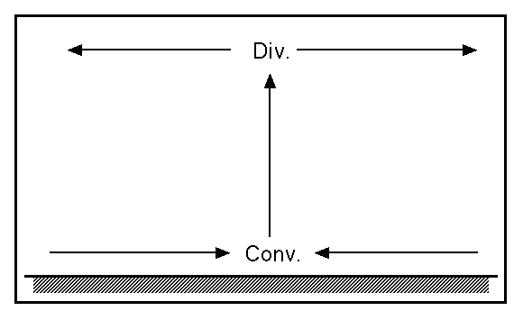
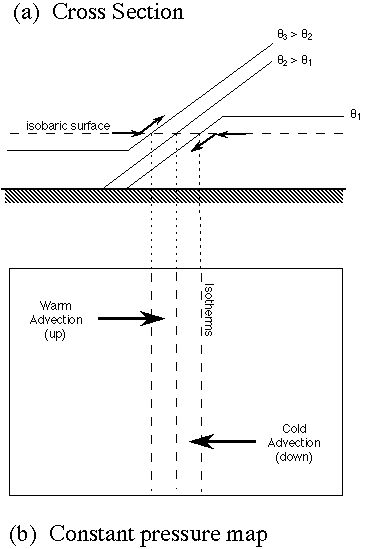